


JACKSON, Wyo. – A strong storm system will move across the Central Rockies this week, resulting in heavy snow across Central and Eastern Wyoming mountain ranges from Wednesday night through Friday morning.
The Tetons will pick up snow as well with Thursday morning impacts over Teton Pass, while the Jackson Hole Valley will only see minor impacts with a mix of light rain and snow showers.
Final Stretch of Beautiful Fall Conditions Leading Up to this Storm
Although we are now heading into a cooler and more unsettled weather pattern, we were able to relish in several days of perfect fall conditions from late last week through early this week.
Cloud cover began to clear from last week’s storm on Thursday (October 5), revealing a coating of snow over the Tetons with peak fall colors in the valleys below. Clear skies and comfortable temperatures prevailed from Friday through Monday (October 6-9) with highs in the upper 60s to low 70s and cold/crisp morning lows in the upper 20s.
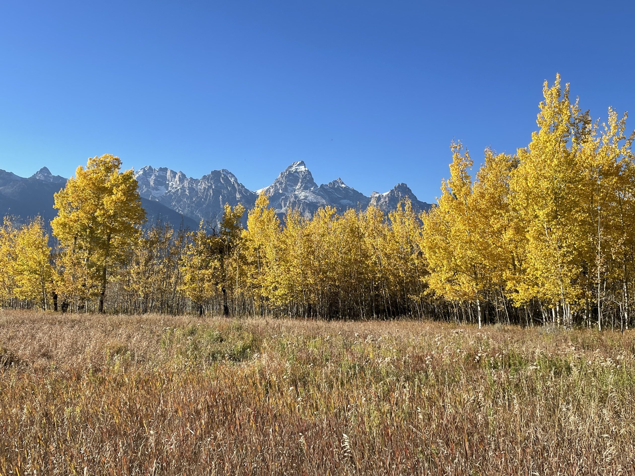
Trail conditions dried out nicely and fall colors were popping all across the region. Here is a shot of an aspen grove in peak color with the snow-capped Tetons in the background on October 7.
We likely saw our last 70-degree day of the year on Monday and moving forward, many trees will shed their leaves this week.
Autumn is a transition season with back-and-forth weather pattern between warm/sunny and cool/wet/snowy. We’ll still see some sunny pleasant days moving forward with 60-degree high temps in the valleys, but the overall trajectory of temperatures is heading downward as the seasons change.
Storm to Impact Wyoming from Wednesday through Friday Morning
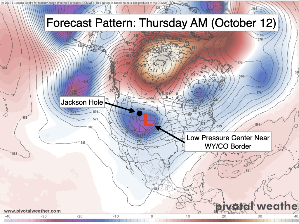
A powerful low pressure system working its way into the Central Rockies will result in cooler temperatures, rain, and snow across Wyoming over the next couple of days. Significant impacts are expected for mountain ranges along and east of the Continental Divide with moderate impacts for the Tetons and Yellowstone.
As the center of low pressure tracks along the Wyoming/Colorado border, winds blowing counterclockwise around the low pressure center will favor the central and eastern ranges of Wyoming for the heaviest precipitation.
Across Jackson Hole and the Tetons, scattered showers will develop on Wednesday with snow levels ranging from 7,500-8,500 feet initially.
On Wednesday evening and overnight (possibly in time for the evening commute over the pass), rain and snow will become more widespread over the Tetons, favoring the western side and upper eastern side of the range, with lighter and more intermittent showers in the Jackson Hole Valley.
Strong northerly winds aloft will develop on Thursday morning with significant moisture and energy moving into Teton County. Northerly winds are not great for the Tetons in terms of orographic/terrain-enhanced precipitation, so there is some uncertainty as to whether or not the dynamics of the storm overcome this or not.
There is a good chance of snow showers, possibly heavy at times, over the Tetons through the morning hours on Thursday but there is both boom and bust potential with this setup. The west side of the Tetons will likely be favored the most as lower-level winds are expected to be out of the north-northwest (as opposed to due north), which could provide some terrain-enhanced lift.
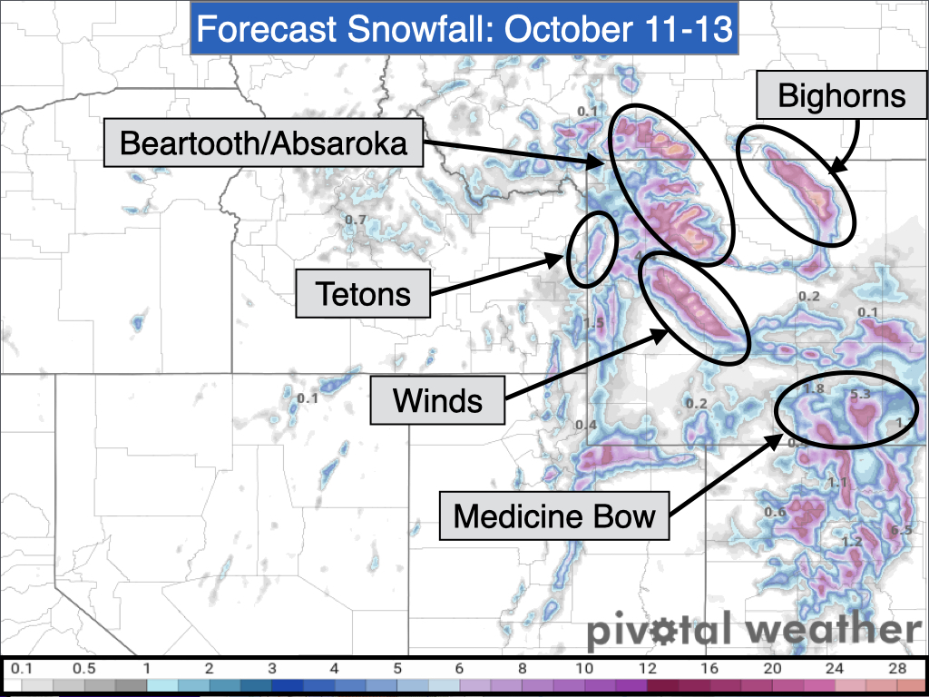
In terms of snowfall amounts, areas above 8,000 feet in the Tetons could pick up anywhere from 3-8 inches of new snow from Wednesday through Thursday PM, favoring the west side. A snowy commute is likely over Teton Pass on Thursday morning.
Snow levels could also dip to the valley floors on Thursday morning, though it will be a close call between rain and snow for Jackson, Victor, and Driggs.
Accumulations are unlikely in the Jackson Hole Valley below 6,500 feet, while heavier precipitation rates in Teton Valley could potentially result in minor grassy accumulations in Victor and Driggs (but it will be a close call and could go either way).
The Jackson Hole Valley is expected to see less precipitation overall, but gusty northerly winds are likely on Thursday.
Star Valley may see snow mix in with rain as well, and some minor grass accumulations couldn’t be ruled out for higher portions of the valley.
Elsewhere, light to moderate accumulations are possible in Yellowstone above 7,000 feet, which will likely impact road conditions on Thursday morning. Togwotee Pass and areas east of Jackson Hole could see heavy snow accumulations with more significant travel impacts from Thursday morning through Friday morning, especially during the overnight and morning hours.
Some of the heaviest snowfall accumulations with this storm are expected in the Beartooth, Absaroka, Wind River, Bighorn, Laramie, and Medicine Bow Ranges.
After this storm, conditions will dry out from Friday through Monday as high pressure gradually builds into the area. However, moisture trapped in the high pressure ridge will result in partly to mostly cloudy skies each day.
Temperature-wise, valley highs will only be in the 40s on Wednesday and Thursday and near 50 on Friday. From Saturday through Monday, highs will range from the mid 50s to low 60s, which is close to average for this time of year.
The next chance of rain/snow will be on Tuesday, but this looks like a weaker storm at this time.
Extended Outlook
For the second half of next week and into the weekend of October 21-22, high pressure will attempt to become established with temperatures generally expected to be above average for mid/late October. However, weak disturbances will remain possible which could result in periods of cloud cover and occasional light precipitation.
Note: My next weekly weather article will be on Wednesday, October 25.
Alan Smith, Meteorologist










