


JACKSON, Wyo. – Following a heat wave that set records in parts of Teton County, thunderstorm chances and coverage will increase over the next 1-2 weeks as a consistent monsoonal flow pattern takes hold, with stronger storms producing locally heavy rain.
Recent Weather
A significant heat wave took hold across Wyoming over the past week in response to an anomalously strong ridge of high pressure that set up over the Northern Rockies and Northern Plains.
Jackson did not break any long-term high temperature records, but when evaluating data from multiple weather stations, this appears to be Jackson’s most significant heatwave since 2003.
Also, long-standing all-time high temperature records were broken in other parts of Teton County, including Moran and Alta.
The Moran weather station, located near Jackson Lake, set its all-time high temperature record on Sunday with a high of 94º, breaking the old record of 93º from July of 2007. Records at this location date back to 1949.
The Alta weather station on the west side of the Teton Range set its all-time high temperature record on Sunday with a high of 98º, breaking the old record of 97º from July of 1925. Records at this location date back to 1909.
The JKNW4 weather station in Jackson, located near the visitor center, recorded highs in the 90s on four straight days, including a high of 96º on Sunday and a high of 94º on Monday and Tuesday.
This weather station has records dating back to 2010, and the high of 96º was the warmest since this time.
The Jackson Hole Airport also has records that only date back to 2009, but the high of 94º that occurred here on Sunday was the warmest since records began here (again, not a long-term record, but significant in terms of recent history).
Mid 90s are hot enough, but a newer weather station (G6490 in the Citizen Weather Observer Program, recognized by NOAA) in East Jackson recorded a high of 101º on Sunday. Over in Teton Valley, the Driggs Airport recorded a high of 99º.
When evaluating longer-term records for the town of Jackson alone and using weather data from the COOP station also located near the visitor center, this heat wave did not reach the intensity of past heat waves that occurred in 2003, 1981, and 1934.
While these recent temperatures were very hot for Teton County, it could have been worse.
For example, Lander tied its all-time record high of 102º, and Worland broke its all-time record high with a scorching 110º.
Other all-time record highs that were set across the Interior West on Sunday include 103ºF in Idaho Falls, 109º in Salt Lake City, and 110º in Billings.
Tuesday was the final hot day of this pattern, and as of Wednesday, temperatures have started to moderate, thanks in part to the arrival of monsoonal moisture from the southwest.
Here is the 7-day weather summary for the town of Jackson:

For perspective, the average high and low temperatures in Jackson on July 15 are 83º and 44º.
Upcoming Weather Pattern
While temperatures will generally remain above average over the next week, the extreme heat is now behind us.
The major pattern change that will occur is the arrival of monsoonal moisture from the Southwest. It looks like a significant monsoonal flow is going to remain in place more often than not for the next couple of weeks, as opposed to the fleeting glimpses we sometimes experience.
What do we mean by “monsoon” exactly?
The North American Monsoon is a seasonal circulation of subtropical moisture that develops over Mexico early in the summer and then pushes northward into the Southwest and Southern/Central Rockies by mid-summer.
Monsoon season technically lasts from mid-June through the end of September, but in the Central Rockies, the more typical season is from mid-July through early September (with year-to-year fluctuations).
Monsoon moisture will periodically surge northward into Western Wyoming at various points during the summer, leading to increases in showers and thunderstorms, but this fluctuates year to year depending on the strength and consistency of the monsoon as well as upper-level wind patterns.
In some years, we can see longer-duration periods of monsoonal flow in the Tetons and Western Wyoming, and it’s looking like this could be one of those years.
Moisture increased on Tuesday night, and as of Wednesday, dewpoints have been in the 50s, which is quite high for our area (not East Coast-level humid, but high for the Mountain West).
Despite the uptick in moisture, a stable atmosphere (partly related to cloud cover earlier in the day) has suppressed thunderstorm development. This is likely to change in the days ahead.
Starting on Thursday, we will head into a pattern that features near-daily rounds of thunderstorms, though coverage will be hit or miss on most days, as is often the case in these setups.
However, this is also a “wet” thunderstorm setup, meaning that storms will produce locally heavy rain, and hopefully most of our region can see some respectable rain totals add up over time.
Moisture levels and thunderstorm coverage will fluctuate day to day, but in general, thunderstorm activity will increase from Thursday to Saturday, followed by a decrease in activity Sunday-Monday, and then another increase heading into the middle of next week.
The 7-day rainfall projection from the European Ensemble Model (a low-resolution projection that represents the average of 50 simulations) has a classic monsoon signature, with moisture tracking from Mexico up through Arizona and Utah into Western Wyoming.
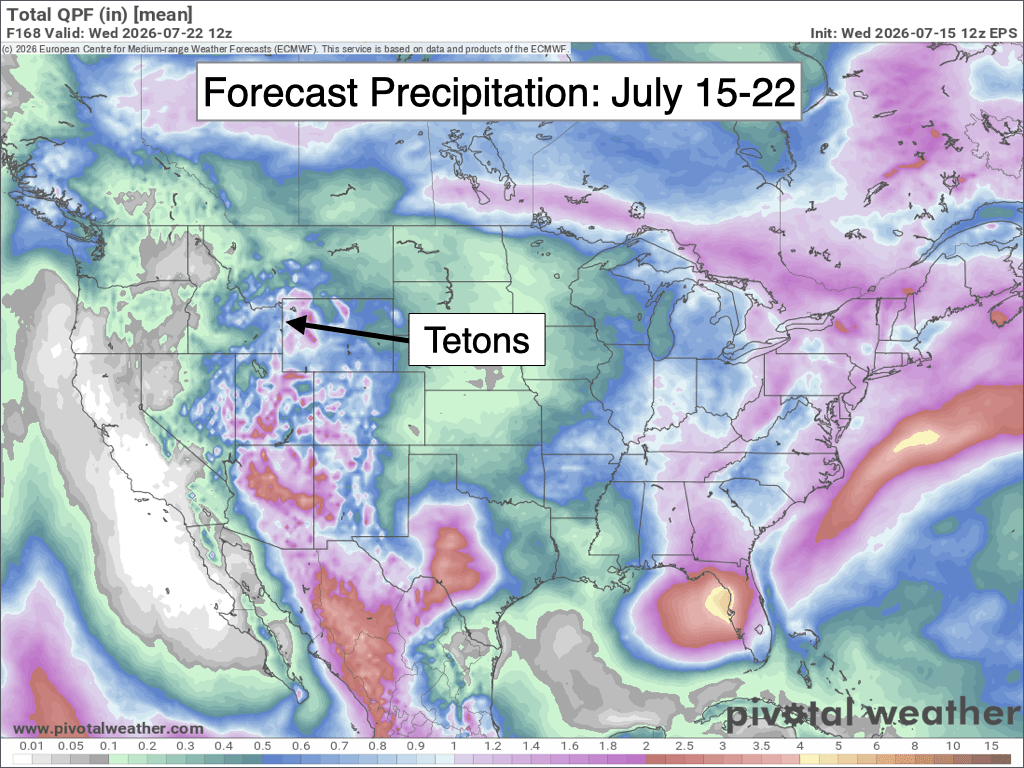
If you have outdoor plans over the next week (and beyond), be prepared for routine afternoon thunderstorm chances and possibly some occasional overnight/morning chances.
Also, while rainfall is hit or miss on any given day in this pattern, stronger storms will be capable of producing torrential downpours, especially on days with slow storm motions. Moisture levels will be high enough in this pattern that an isolated flash-flooding risk will also exist in steep, narrow, and rocky terrain in the backcountry.
Long Range Outlook
Looking further out, the emerging strong El Niño, along with above-average ocean temperatures in the Gulf of California and South Pacific, favors an active mid- to late-summer monsoon pattern in our area, beyond even just the next two weeks. Long-range weather models are also hinting at this.
Here is a look at the July-September rainfall outlook from the monsoon season outlook that I recently wrote for OpenSnow, which indicates an above-average signal for the Tetons.

Keep in mind that, climatologically speaking, summer is a drier time of year in the Tetons on average, so this doesn’t mean we are going to get massive quantities of drought-busting rain.
But nevertheless, it is an encouraging signal for meaningful mid to late summer rain that could potentially help to mitigate the fire risk and worsening drought concerns if this pattern were to verify.
Speaking of the emerging strong, or “super,” El Niño, I’m already getting a lot of questions about what this means for the Teton winter.
As it turns out, there is not much of a signal for the Tetons, as strong El Niño years give us roughly a 50/50 shot at above- or below-average snowfall, with many past years featuring snowfall that was very close to average.
Alan Smith, Meteorologist










