


JACKSON, Wyo. – A trough of low pressure will move across the area this weekend, pulling in moisture from the remnants of tropical activity in the Eastern Pacific to result in an increasing potential of significant rainfall this weekend along with cooler temperatures.
Recent Weather Conditions
Over the past week, we saw one final brief heatwave with highs pushing into the 90s, followed by thunderstorms over the weekend that produced locally heavy rain along with hail.
The heat wave peaked on Thursday and Friday with highs of 90ºF and 92ºF recorded in Jackson. The JKNW4 weather station has now recorded high temperatures of 90ºF or higher on 14 days this summer, which is the most of any summer since records at this station began in 2010.
The highest number of 90+ degree days in a summer between 2010 and 2015 was 11 days, which occurred in 2012 and again in 2014. The 2010-2025 average for 90+ days in a year was 4.6, so we have tripled that value this summer.
Based on the time of year and the forecast ahead (more on that below), we are likely done with 90+ degree heat for the rest of the summer.
Last weekend, a surge of monsoonal moisture arrived from the southwest, fueling active thunderstorm days from Saturday to Monday, though storm coverage was hit or miss as is often is at this time of year.
The town of Jackson was hit the hardest of any areas in our region as a series of strong thunderstorms tracked through the area on Sunday afternoon, producing 0.81 inches of rain in just over an hour along with accumulating hail.
Total rainfall over the past week exceeded an inch in East Jackson, while the north side of town picked up around three quarters of an inch. Elsewhere, measured rain totals ranged from 0.4 to 0.8 inches in the Tetons, while Mt. Baird in the Snake River Range picked up 1.5 inches.
For the month of August as a whole, we are running above average for precipitation throughout Northwest Wyoming and Eastern Idaho.
Here is the 7-day weather summary for the town of Jackson:
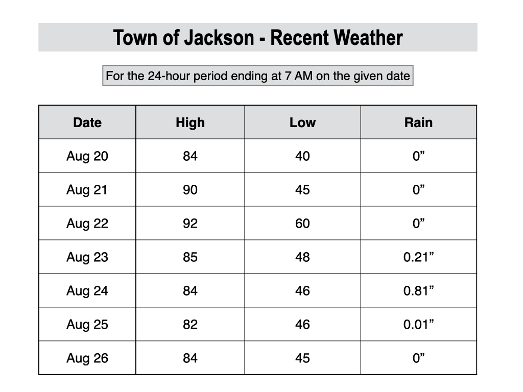
For perspective, the average high and low temperatures in Jackson on August 19 are 79º and 40º.
Upcoming Weather Pattern
We are experiencing a bit of a lull during the middle of the week with just some isolated afternoon thunderstorm activity. However, confidence is growing that we will see another wet and active stretch to wrap up the month of August, just in time for the weekend.
The change will be subtle at first on Thursday as a shortwave disturbance arrives from the southwest, which will bring in an uptick in monsoonal moisture along with a better chance of afternoon thunderstorms compared to the past couple of days. Temperatures will remain warm with highs in the mid 80s.
However, the main event will be from Friday to Sunday (and especially on Saturday) as a Pacific trough of low pressure approaches. Southwest flow ahead of this trough will pull in moisture from the remnants of tropical activity in the Eastern Pacific to set the stage for an uptick in showers and thunderstorms.
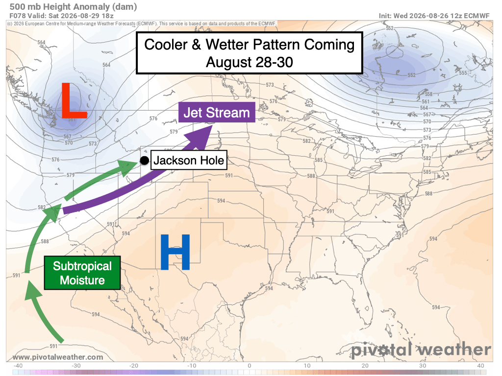
On Friday, scattered showers and thunderstorms can be expected with the highest odds during the afternoon per usual, though some models are also hinting at possible morning activity, so keep an eye on this if you have early outdoor plans. Highs on Friday will be in the 70s in the valley.
Saturday is shaping up to be the most active day as a cold front moves through, with cooler temperatures and more widespread rain showers possible during both the morning hours (including pre-dawn) and afternoon hours. Highs will only reach the 60s in the valley, and the lightning risk will also be reduced (but not zero) in response to this cooler airmass.
Scattered showers will remain possible on the backside of the low pressure system on Saturday night and Sunday, though confidence is a bit lower compared to Saturday. Highs will struggle to get out of the 60s again on Sunday.
Most weather models are projecting rain totals of 0.5 to 1.25 inches across the Greater Teton Region through Sunday. Keep in mind that this could change as we are still several days away, but the bottom line is that you should be prepared for wet conditions (and cooler temps) if heading into the backcountry this weekend.
Also, snow is likely to dust the higher peaks in this pattern. On Saturday, snow levels (the rain/snow line) are projected to range from 12,000 to 13,000 feet (the top of the Grand is 13,775 feet), while on Sunday, snow levels could dip as low as 10,500 to 11,500 feet.
Heading into early next week, we should see a bit more sun peaking out with highs warming back up into the 70s. However, the pattern looks to remain unsettled with additional rounds of scattered showers and thunderstorms possible on Monday and Tuesday.
The 7-day rainfall projection below represents the average of 50 simulations of the European Weather Model.
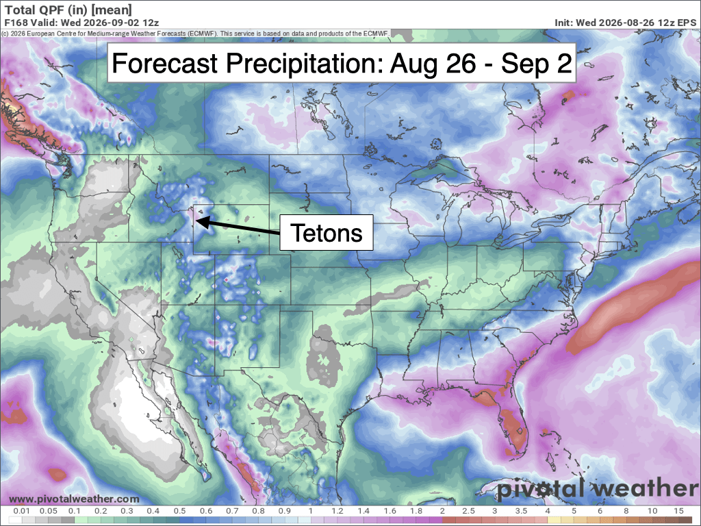
Looking further out beyond September 2nd, confidence decreases in terms of any potential weather systems, but in general, the pattern may stay somewhat unsettled. NOAA’s 8-14 Day Outlook favors a slight lean toward above-normal precipitation with near-normal temperatures expected.

Looking even further out and at the big picture, El Nino conditions to strengthen in the Pacific and confidence is growing that this could become a record-setting El Nino event in terms of above-average sea surface temperature anomalies in the Eastern and Central Equatorial Pacific.
The strengthening El Nino has likely been a factor in our wetter-than-average late summer this year, as this is consistent with historical analogs.
Looking at past strong and eastern-based El Nino events (meaning warmth is most heavily concentrated in eastern portions of the Pacific), we tend to be favored for above-average precipitation in September-October of such years and below-average precipitation in November-December.
That doesn’t mean it will play out exactly that way this year (every year is unique), this is just what we have seen historically when examining past similar years.
However, the overall winter signal is neutral during these stronger El Nino phases, meaning that there is no lean in either direction in terms of Teton winter snowfall compared to average.
Temperatures do tend to be warmer than average during El Nino winters as frequent strong Pacific flows tend to keep arctic air bottled up to the north more often than not. But at the same time, it’s unlikely we will see the same level of anomalous warmth that we experienced last winter.
Alan Smith, Meteorologist











