


JACKSON, Wyo. – Rainfall totals last week ranged from 1-3 inches across Teton County. A milder pattern with increased sunshine and highs in the 70s can be expected from Thursday to Saturday, with the next chance of showers expected Sunday-Monday as a cold front approaches.
Recent Weather
Cool and damp conditions have largely prevailed over the past week across the area.
Following a warm day last Wednesday in which the high topped 78ºF in Jackson, the pattern turned much wetter and cooler from Thursday to Saturday as a slow-moving low pressure system worked its way across the area.
This low pressure system tapped into subtropical moisture associated with the Southwest Monsoon, which is a bit late in the year for us climatologically speaking. However, cooler air also pushed into the area and increased cloud cover resulted in highs in the upper 50s to low 60s from Thursday through Sunday.
Thursday to Thursday night ended up being the wettest period overall, when atmospheric moisture levels were the highest, and we also had a southerly flow develop which tends to favor the Southern/Eastern Tetons and Jackson Hole Valley – often precipitation is heavier in these setups than models project, and that was the case here.
Jackson picked up 0.82 inches of rain from Thursday through Thursday night, while the Tetons and Snake River Range received well over an inch.
Thunderstorms were also common in this pattern, despite the cooler surface temperatures, due to abundant atmospheric energy “energy”, a subtropical moisture feed, and steep lapse rates (rate of temperature decrease with altitude) in the middle to upper levels of the atmosphere.
An intense cluster of thunderstorms moved through the Jackson Hole Valley during the overnight hours on Thursday night/Friday morning, likely waking many people up as there were some close lightning strikes in the town of Jackson.
Cool and wet conditions prevailed on Friday and Saturday, though rainfall was generally more scattered in nature. In fact, the town of Jackson did not receive any rainfall on Saturday.
Sunday was cool and cloudy but with no additional rainfall. Monday started out chilly with low temperatures around freezing underneath a thick valley fog, but we saw a break on Monday afternoon with sunny skies and a high of 71ºF.
A weaker disturbance moved through on Tuesday and Tuesday night, bringing more heavy cloud cover and cooler temperatures with highs in the 50s. The Jackson Hole Valley only received light rainfall with less than a tenth of an inch, while the southern end of the Tetons picked up 0.2 to 0.4 inches of rain.
The west side of the Tetons saw heavier rain on Tuesday-Tuesday night, with Targhee picking up 0.6 inches and Teton Valley 0.2 to 0.4 inches.
Despite the cooler and wetter pattern over the past week, there have not been any significant shots of cold air with any of these systems, and snow levels have remained high as a result, generally above 10,000 to 11,000 feet. So only the higher peaks have been getting dusted with snow.
Here is the 7-day weather summary for the town of Jackson:

For perspective, the average high and low temperatures in Jackson on September 23 are 70º and 33º.
Upcoming Weather Pattern
The overall trend will be toward warmer and drier conditions through Saturday, followed by another cooling trend with at least some chance of rain early next week.
Wednesday has featured partly cloudy skies and highs in the upper 60s so far. On Thursday, we will see more abundant sunshine with highs warming up into the mid 70s after a chilly start. It looks like a beautiful day to get outside.
Friday and Saturday also look dry and mild with highs reaching the low 70s, but a shortwave trough moving across the Northern Rockies will lead to gusty winds, especially during the afternoon hours. However, no appreciable moisture will arrive with this system, and no rain is expected as a result.
On Sunday-Monday, a trough of low pressure will move through the Interior Western U.S. and a cold front is also expected to move through sometime in the Sunday PM to Monday AM timeframe.
This trough is likely to “split” with deeper moisture and energy setting up to our south across the Southwest into Colorado, with more limited moisture expected for the Tetons and Western Wyoming.
However, we still have a decent chance of picking up at least some rain on Sunday and Monday, and in the warmer sector ahead of the front on Sunday, we could also see some thunderstorms.
Highs are projected to reach the upper 60s to low 70s ahead of the cold front on Sunday, and upper 50s to low 60s behind the front on Monday. But keep in mind, these projections could change as we get closer.
Snow levels are also expected to stay fairly high in this pattern. Most model projections have snow levels dropping to 10,000 to 11,000 feet behind the front on Monday, but some outlier colder solutions have snow levels potentially dipping as low as 9,000 feet toward the end of the event.
Conditions should dry out on Tuesday-Wednesday behind this system, but temperatures look to stay seasonally cool with highs in the 60s.
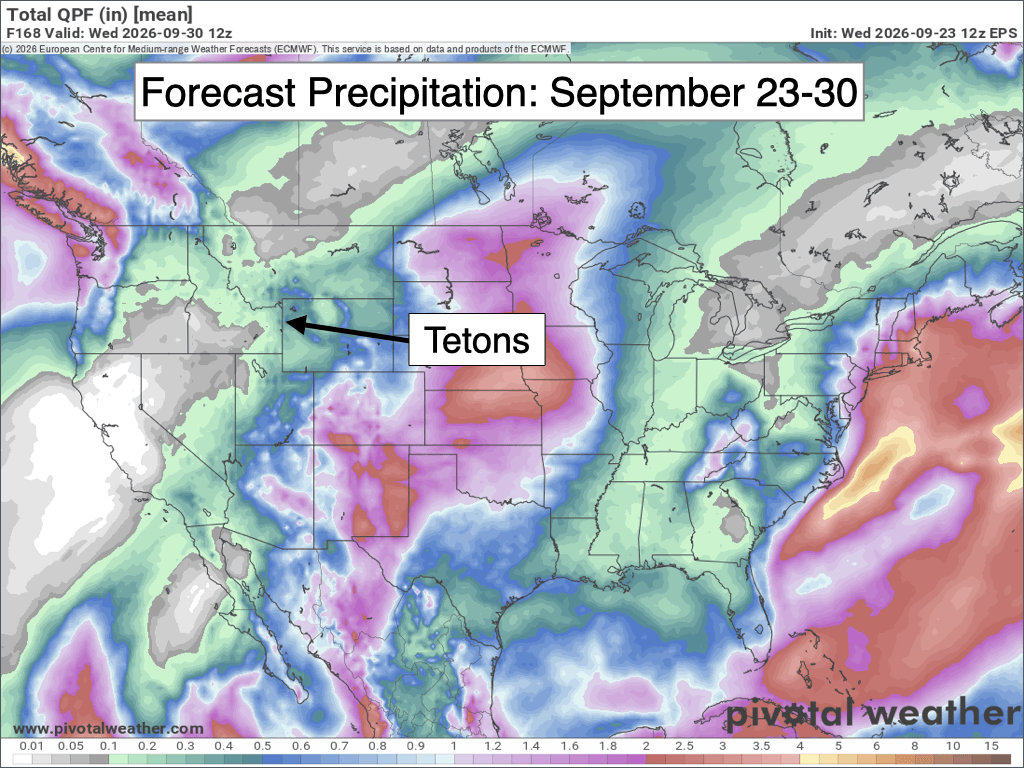
The 7-day precipitation projection below represents the average of 50 simulations of the European Model. Notice that precipitation amounts are expected to relatively light across the Tetons and Western Wyoming, and much heavier over Colorado and New Mexico to the south.
Looking further out, there are some hints of a possible storm system and cold front around October 2-4, but as expected for being 10 days out, not all models are on board with this solution and confidence is low.
Beyond October 4, longer range models are trending toward a warmer and drier pattern with high pressure building over the Western U.S. NOAA’s latest 8-14 day outlook is picking up on this signal as well with above-average temperatures and below-average precipitation favored.
In other words, don’t pack away your trail gear or mountain bikes for the season just yet!

Alan Smith, Meteorologist











