


JACKSON, Wyo. – An impressive fall storm system produced 1.5 to 3.5 inches of rain across Teton County from October 10th to 13th. Snow levels were around 10,500 feet for much of the event, before lowering a bit on Tuesday when the upper slopes of JHMR and Targhee picked up 1-3 inches of snow.
Recent Weather Pattern
Jackson Hole experienced a substantial pattern change over the past week, with near-record warmth during the middle part of last week giving way to cold and wet conditions over the weekend as a multi-day heavy precipitation event unfolded.
Last Wednesday and Thursday, we saw high temperatures hit 79º and 78º in the town of Jackson under abundant sunshine. Friday was likely our last 70+ degree day of the year with a high of 74º, though cloud cover did increase in the afternoon with a few spotty showers and thunderstorms late in the day.
The storm system from Saturday through Tuesday featured two separate low-pressure areas and substantial moisture from the tropics that made it all the way to Jackson Hole.
Check out some of these storm total precipitation amounts from across the area…

On Saturday and Sunday, the main influence of our storm came from tropical cyclone Rachel in the Pacific, which made landfall on the Northern Baja Peninsula and then traveled from south to north through Southern California, Utah, and Eastern Idaho/Western Wyoming as a post-tropical system.
On Saturday, the onset of this system involved intermittent showers, a few strong thunderstorms, and locally heavy rainfall rates as moisture initially increased from the southwest.
On Sunday, a more widespread steady rain developed, with 24-hour rain totals from Sunday morning through Sunday night ranging from 0.7 to 1.8 inches across the area. Despite the significant precipitation, snow levels were around 10,500 feet.
On Monday and Tuesday, a second area of low pressure originating from Canada slowly worked its way across the Great Basin and eventually into Utah, tracking south of our area. South to southeast winds transported additional subtropical moisture into the area, resulting in off-and-on showers both days.
Snow levels gradually lowered during this period, eventually dropping as low as 8,000 to 8,500 feet on Tuesday when a very light dusting of snow was observed on grassy surfaces at the top of Teton Pass.
Areas between 9,000 and 10,000 feet (the upper portions of JHMR and Targhee included) also picked up 1-3 inches of snow during this final round on Tuesday.
During the day on Wednesday, the sun came out for the first time in several days, and the fresh snow between 9,000 and 10,500 feet was already melting quickly as of early afternoon, while the higher peaks of the Tetons, where heavier snow fell and where temperatures are colder, will not melt out again until next summer.
Total rainfall during this event ranged from 2.5 to 3.5 inches across the southern and eastern Tetons, including JHMR and Teton Pass, while the Jackson Hole Valley received 1.6 to 2.1 inches of rain. On the west side, Teton Valley picked up 1.3 to 1.7 inches of rain.
The town of Jackson received 1.9 inches of rain during this 4-day stretch, and another rain gauge just south of town recorded 2.06 inches of rain.
This was the wettest 4-day period in town since the infamous Christmas rainstorm last year, when 2.20 inches of rain fell in town from December 22-25, 2025.
Here is the 7-day weather summary for the town of Jackson:

For perspective, the average high and low temperatures in Jackson on October 14 are 59º and 27º.
Upcoming Weather Pattern
We are heading back into a dry and mild pattern from Wednesday, October 14 to Monday, October 19 as a ridge of high pressure builds over the Western U.S. It will not be as warm as what we saw last week, but from Thursday to Monday, we can expect highs in the 60s in the valley each day along with abundant sunshine.
Nights and mornings will be the coldest we have seen so far this season, however, with lows dipping into the low 20s in the valleys on most days.
While most hiking trails will be snow-free heading into the weekend, stretches of damp and muddy trail conditions may persist in some areas given the shorter days and weaker sun at this time of year, along with daily melt/freeze cycles on the trails.
Heading into early next week, the next storm system will originate in the Gulf of Alaska, before diving southward along the West Coast and eventually developing into a cut-off low. Cut-off lows are slow-moving and erratic by nature, and tough to pin down far in advance, so what, if any, impacts we see here in the Tetons next week are highly uncertain.
We could see at least a slight chance of precipitation in our area as early as next Tuesday, but recent model trends are hinting that a better chance may hold off until the second half of next week.
The 7-day precipitation projection from the European Ensemble Model through the morning of October 21st looks sparse for Western Wyoming.
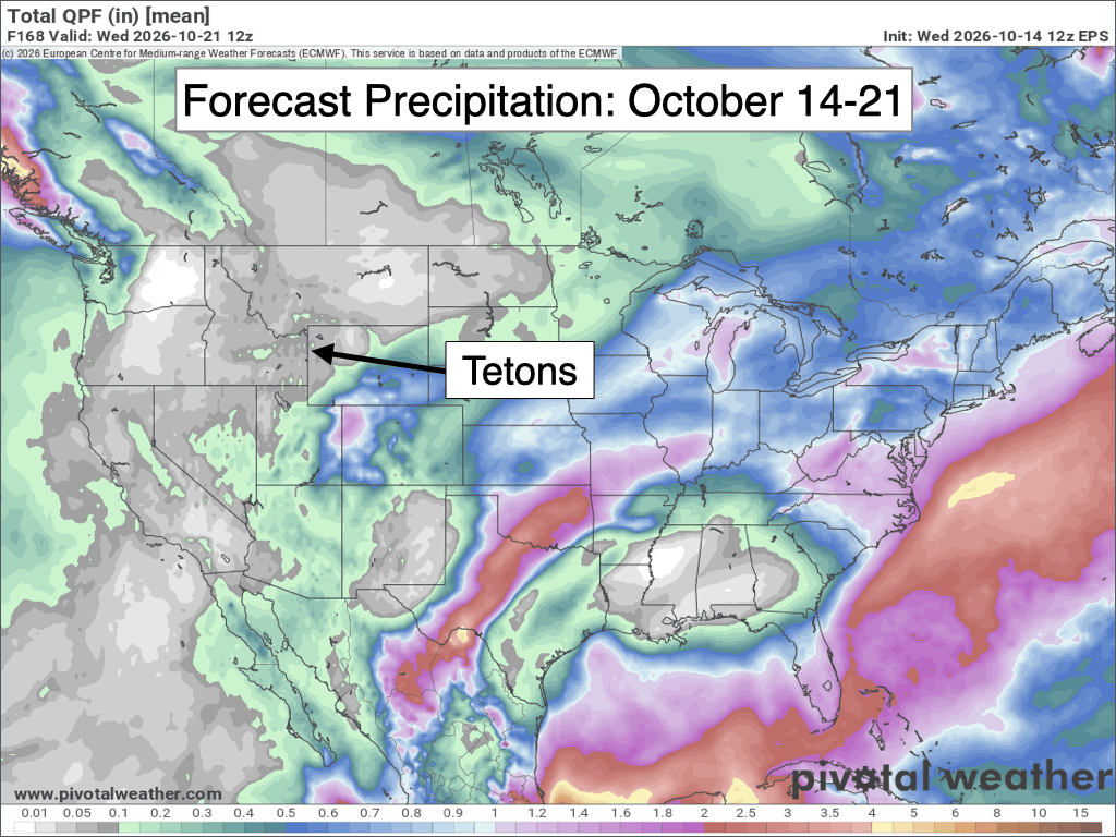
The pattern could turn more interesting during the second half of next week, in roughly the October 22-25 timeframe. However, the track of this system is highly uncertain this far out.
If the system progresses inland and tracks far enough north, then our chances of rain and snow would increase. But there is also a chance the system stays too far south and misses our area entirely.
Temperatures and snow levels are also highly uncertain this far out, since we’re more than a week away.
Alan Smith, Meteorologist











