


JACKSON, Wyo. – November has been a mild month weather-wise for Jackson Hole and throughout the Western U.S. The pattern will turn more active over the first few days of December with significant snowfall expected in the Tetons.
November 2023 Recap
This November has been the complete opposite of what we experienced last November. If you recall, November 2022 was one of the coldest on record in Jackson Hole and snowfall was also significant, with 84 inches recorded at Jackson Hole Mountain Resort and 20.6 inches in the town of Jackson.
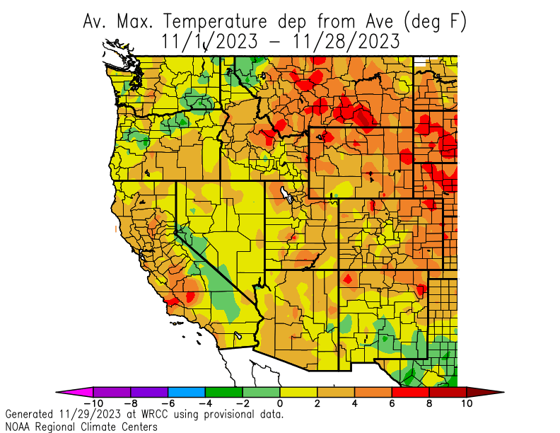
During November 2023, temperatures are running 4.7ºF above average in the town of Jackson as of November 29, and 4.3ºF above average at the Moran/Jackson Lake weather station.
Temperatures have been warmer than average this month across the Western U.S. as a whole.
Snowfall has also been light this month. The Rendezvous Bowl Plot at Jackson Hole Mountain Resort (9,580 feet) has received 33 inches of snow this November, which is well below the historical November average of 59 inches.
Snowfall in the town of Jackson during November ranged from 3 inches in East Jackson to 4.2 inches in North Jackson, all of which fell during the Thanksgiving storm. Average November snowfall in Jackson is 11.5 inches.
Snowpack (the amount of snow on the ground) is only 58% of average for the date on the upper mountain of Jackson Hole Mountain Resort, and 36% of average at mid-mountain. Snowpack is also below average across nearly the entire Western U.S.

The town of Jackson received a total of 1.43 inches of precipitation (Cocorahs WY-TT-40 location) during the month of November, which is slightly below the historical average of 1.71 inches. Heavy rain during the first week of November was a large contributor to the monthly total.
Snowy Pattern Ahead for Early December
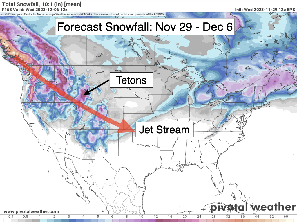
The dry spell is about to come to an end, at least for a little while, as a series of storms is slated to impact the Tetons from Thursday night through Monday. At the very least, this pattern should provide a welcome boost in early season snowpack at our local ski resorts.
The first storm cycle from Thursday night through Saturday night will arrive from the northwest and will feature cold temperatures and the potential for significant snow amounts in the Tetons.
Three-day snow totals through Sunday morning are currently expected to range from 8-16 inches in the Tetons and 2-6 inches in the Jackson Hole Valley. Strong west/southwest winds are also expected to develop during the day on Saturday.
Travel impacts will be felt over Teton Pass and in the valleys during this cycle with snow-packed roads along with areas of blowing snow and reduced visibility.
Another storm will arrive on Sunday-Monday with the potential for moderate to heavy snow, but this storm will involve a surge of subtropical moisture which will result in warmer temperatures and a transition to wetter/denser snow.
Here is a 7-day snowfall projection from the European Ensemble Model:
After the Sunday-Monday storm, we should see a break in the pattern heading into the middle of next week, but a warm airmass will take hold with high temperatures rising into the 40s in the Jackson Hole Valley. Skiing conditions will not be great as a result, but the snowpack will be deeper at least.
Toward the end of next week, we may see a shot of colder air arrive along with our next chance of snow.
Alan Smith, Meteorologist











