
JACKSON, Wyo. – October was much warmer and drier than normal in Jackson Hole and Wyoming, and wildfires burned late into the month. An abrupt transition to colder weather has occurred in early November, and the month is looking more active overall.
October 2024 Recap
October was very mild across the region and many summer activities remained in good condition up until the end of the month. The downside is that wildfire smoke was also an issue for much of October, which is not something that typically happens at this time of year.
The Pack Trail Fire experienced significant growth through mid-October during a multi-week stretch of warmer and drier-than-normal conditions. Fortunately, the arrival of cold air and moisture at the end of the month put an end to the fire and all evacuation orders were lifted.
For the month as a whole, temperatures ended up 3.9ºF above normal in Jackson with an average high of 65.3ºF and an average low of 25.4ºF. The highest temperature of the month was 79ºF on October 4, and the lowest temperature of the month was 18ºF on October 25.
The average high temperature in October 2024 was 8.9ºF warmer than normal while the average low temperature was 1.2ºF cooler than normal, which speaks to how dry the month was which allowed for strong radiational cooling at night.
Historically, the average difference between the daily high and low temperature in Jackson in October is about 30 degrees, but in October 2024, the average difference was 40 degrees.
Accounting for both the high and low temperatures, which gave us an overall temperature departure from normal of +3.9ºF, this was the warmest October in Jackson since 2015. At the Moran weather station near Jackson Lake, this was the warmest October since 1988 and the third warmest October on record, dating back to 1912.
The town of Jackson reached 70ºF or higher on 14 of the first 16 days of October, which is unusual for this late in the season. The final two weeks of the month brought cooler temperatures, but we still had a high of 66ºF as late as October 27.
The map below shows the departure from normal temperatures across the Western U.S. in October 2024.

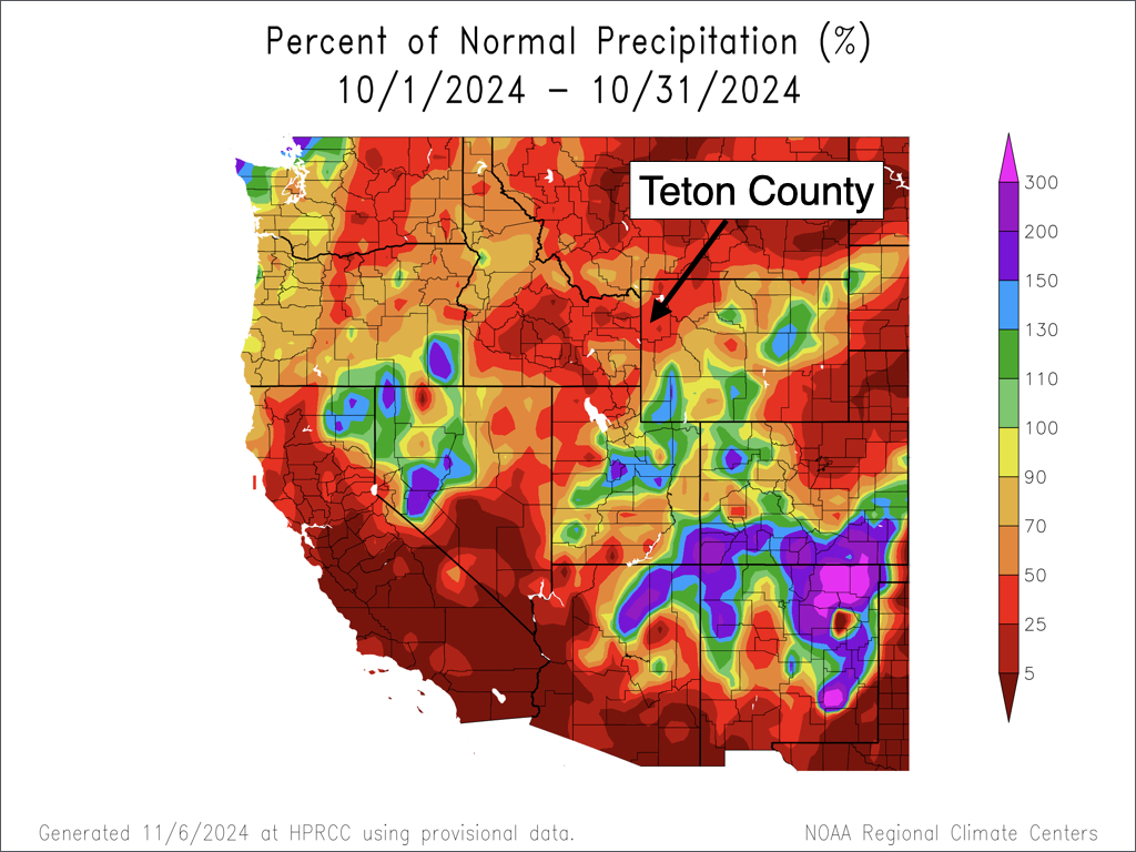
October also started out very dry as we did not receive any measurable precipitation in Teton County until October 17. For the month as a whole, Jackson received 0.61 inches of precipitation, which is well below the monthly average of 1.82 inches.
Most of the precipitation that fell in town was rain, but some non-accumulating snow did fall in town late in the month.
Measurable snow did not occur in town until the evening of October 31. Historically, 24-hour snow totals are issued in the mornings between 5am and 9am (depending on the weather station), so this snowfall “officially” counted as snow for November 1 rather than October 31. As a result, October 2024 officially ended with zero measurable snowfall in town.
Mountain snowfall was very light through the end of October, ranging from 3 to 9 inches in the Tetons above 9,000 feet. The Rendezvous Bowl Plot at 9,580 feet averages 31 inches of snowfall in October, for perspective.
Fortunately for skiers, October snowfall has little bearing on the ski season ahead. November and December are when snow accumulations really start to matter for building up the snowpack.
Most of the Western U.S. was also drier than normal in October, though there were some wetter spots across the Four Corners region, and a few isolated wetter areas in Southern/Eastern Wyoming.
November Outlook
November is the month when winter really starts to set in across our area. Climatologically, November is the fourth coldest month of the year and the fifth snowiest month of the year in the valley (sixth snowiest in the mountains, as April is slightly snowier up high).
The sun angle is low enough by this time of year, and temperatures cold enough, so that snow that falls in the mountains typically doesn’t melt, and the snowpack really begins to grow as the month progresses.
Valley snowfall does not always stick around in November, at least near town. But usually by the end of the month, valley snow is here to stay for the winter.
In the town of Jackson, the average high temperature in November is 41.1ºF and the average low temperature is 18.1ºF. However, by the end of November, average highs are in the mid 30s.
Average November precipitation in the town of Jackson is 1.44 inches and average snowfall is 11.7 inches. November snowfall can fluctuate widely from year to year. In November 2023, Jackson only received 4.2 inches of snowfall, but in November 2022, Jackson received 20.6 inches of snowfall.
The Rendezvous Bowl Plot at 9,580 feet averages 59.1 inches of snowfall in November. The snowiest November on record at this location was 92 inches in 2010, but we nearly matched this in 2022 with 91 inches.
November 2024 is already looking much different than October 2024. Temperatures through the first six days of the month have been colder than average, and the transition has been sharp with highs in the 60s being replaced with highs in the 30s.
Several light to moderate snow events have occurred and have added up to respectable amounts over time. Through the first six days of the month, snowfall totals have ranged from 10-20 inches in the Tetons and 2-6 inches in the Jackson Hole Valley.
While a four-day dry spell is currently underway, it looks like an active pattern will resume around November 10 and continue for at least another week. Big picture, the pattern this month will favor low pressure troughs over the Western U.S. and a dominant ridge of high pressure over the Eastern U.S.
For as mild as October was, November will likely end up near to below normal in terms of temperature, and near to possibly above normal in terms of precipitation and snowfall. This is a favorable outlook for the early ski season, with Grand Targhee and Jackson Hole Mountain Resort opening later this month.
In the near term, dry conditions will continue through Saturday with warmer temperatures in the mountains, while a temperature inversion will likely set up in the Jackson Hole Valley, leading to continued cold temperatures with highs in the 30s and lows in the single digits to low teens.
On Sunday, a weak disturbance will bring some light snow showers, and the inversion will also erode with warmer temperatures for the valley. Heading into early next week, a stronger storm is possible which could result in more significant snowfall.
Here is a snowfall projection through November 16…

Alan Smith, Meteorologist


