
JACKSON, Wyo. – Jackson hit 95ºF last Saturday, which was the hottest temperature in town since 2003. Temperatures have cooled since then, with an active thunderstorm day on Tuesday giving way to smoky conditions on Wednesday. Thunderstorm chances return this weekend.
Hot Temperatures Last Saturday
Saturday, August 3 was a scorcher by our standards with highs soaring well into the 90s throughout the valleys on both sides of the Tetons.
The town of Jackson (JKNW4) weather station hit 95ºF on Saturday afternoon, making this the hottest day in town in many years.
The JKNW4 weather station only has data going back to 2009. The COOP station nearby has exhibited an obvious cool bias in temperature readings since about 2009 or 2010 and is less reliable as a result.
Based on past data at this station prior to 2009, the last time a high temperature of 95ºF or higher occurred was in 2003. That summer was very hot in Jackson Hole with a high of 97ºF recorded in July of 2003, while 95ºF was also reached in August of 2003.
Based on JKNW4 data since 2009 and COOP data prior to 2009, Jackson’s 95ºF reading last Saturday also “unofficially” set a new record high for the date, breaking the old record of 93ºF set in 1979.
The Jackson Hole Airport also recorded a high of 93ºF last Saturday. Airport weather data is only available since 2009, but this is the hottest temperature recorded at the airport since records began.
The culprit was a very strong ridge of high pressure centered over Northern Utah, that is often referred to as a “heat dome” at this time of year. It was already very hot to our south over Utah and Nevada, and strong southwest winds blowing clockwise around the high pressure center helped to transport this hot air into our region.
Also, low temperatures were unseasonably warm the following morning (Sunday, August 4) with a low of 63ºF in Jackson. This was the warmest low temperature measured in town since 2014. This was a rare overnight period in which natural air conditioning was limited in town.
Beyond the Tetons, numerous record highs were also set across Western and Central Wyoming. Lander hit 100ºF and Riverton also tied its all-time record high for August with 99ºF recorded.

Thunderstorms on Tuesday
It has been a very dry summer in the Tetons and thunderstorm activity has generally been unimpressive, with only occasional isolated to scattered storms bringing brief light rain and gusty winds.
Tuesday was a more active day, however, as stronger thunderstorms moved across Teton County, producing frequent lightning.
A cluster of storms moved across the Teton Range from west to east early to mid-afternoon, but rainfall was limited due to the fast-moving nature of the storms.
A relatively narrow corridor from the south side of Teton Pass to Wilson to Jackson ended up being the big winner with Tuesday’s thunderstorm activity.
A series of strong thunderstorms developed across this stretch (possibly along a localized wind convergence boundary) and passed through town, producing heavy downpours and pea-sized hail.
Jackson received 0.26 inches of rain, which is the highest rainfall total measured in one day since the beginning of June. Further north, rainfall amounts were generally less than 0.05 inches.
While the rain was a welcome sight in Jackson, unfortunately, lightning on the outer fringes of these storms triggered a wildfire in Moose Creek Canyon on the west side of Teton Pass.
The fire is small as of early Wednesday, but dry and breezy conditions in the forecast on Wednesday and Thursday along with challenging terrain could make firefighting efforts difficult.
Wildfire Smoke Returns to the Area
We saw a wonderful break from the smoke late last week through early this week with improved visibility and air quality. Unfortunately, the smoke is back as of Wednesday.
Fire activity to our west (Washington, Oregon, Idaho, and California) has ramped back up in recent days due to hot, dry, and breezy conditions, and strong westerly winds associated with a trough moving across the Northern Rockies are transporting this smoke back into our area.
Smoke Model for 4 p.m. Wednesday:

Varying levels of smoke will likely persist through the weekend with west/southwest winds aloft expected to continue.
Dry and Breezy Wednesday through Thursday
Dry air has moved into Western Wyoming on Wednesday, but winds will be gusty in response to a cold front approaching from the north and northeast.
The front will eventually move through our area on Thursday with continued gusty winds, while temperatures will be a little cooler with highs in the low 80s in the valleys.
Rain and thunderstorms are not expected in the Tetons, but areas east of the Continental Divide will see an uptick in moisture with more numerous thunderstorms and locally heavy rain. This includes the Winds, Absarokas, and Bighorns.
Yellowstone could also see some isolated thunderstorms, and a more noticeable cooldown is also expected there compared to the Tetons.
Thunderstorm Chances Return Friday through Early Next Week
The pattern will turn more interesting for the Tetons and Western Wyoming as monsoonal moisture arrives from the southwest. This moisture surge does not look as impressive compared to the past three Augusts, but it looks more impressive than anything we’ve seen so far this summer.
As a result, we should expect daily thunderstorm chances with at least a chance of locally heavy downpours. However, there could also be some dry lightning strikes outside of thunderstorm cores that could trigger wildfires, similar to what occurred on Tuesday.
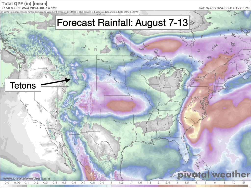
We have some things working for and against meaningful rain in this pattern. Strong winds aloft will result in fast-moving storms, which can limit rainfall due to shorter durations.
However, if monsoonal moisture becomes established over our area for several days or longer, it could lead to a feedback that allows the lower levels of the atmosphere to “moisten” over time.
This can lead to more productive rainfall and heavier rainfall rates as opposed to “high-based” thunderstorms when moisture is concentrated higher up in the atmosphere – in these cases, rainfall tends to be lighter and more spotty and winds tend to be strong and erratic.
Also, disturbances in the upper atmosphere that often coincide with stronger winds aloft can sometimes lead to more widespread thunderstorms and multiple rounds of showers and storms.
We’ll see what happens, and keep our fingers crossed that we can pick up some beneficial rainfall without the side effects of wildfire starts and exacerbated fire behavior. One other potentially negative effect of thunderstorms with ongoing fires is the gusty/erratic winds that can occur.
In addition to moisture needs and fire behavior, it’s also good for climbers, hikers, and other outdoor users to be aware of this expected uptick in thunderstorm activity from a safety standpoint.
Thunderstorms are most common in the afternoon and early evening hours, but a combination of monsoonal moisture and upper atmospheric disturbances can occasionally result in “surprise” morning activity as well.
Alan Smith, Meteorologist


