


JACKSON, Wyo. – A storm system will bring rain, snow, and colder temperatures to Teton County this weekend, with snow levels possibly reaching the valley floor by Sunday morning. More storms are possible next week as well.
Recent Weather
Mild and sunny conditions during the middle of last week gave way to colder and wetter conditions over the weekend as a storm system moved through.
Many areas received significant rainfall on Friday night and Saturday, before a cold front moved through on Saturday night with accumulating snow in the Tetons through Sunday.
Areas between 8,000 and 10,000 feet in the Tetons received 2-4 inches of snow from Saturday night to Sunday. Snow briefly mixed in down to the valley floor in some areas on Sunday morning, but for the most part, this was a rain event down low.
Precipitation amounts ranged from 0.7 to 1.4 inches across Teton County (Wyoming and Idaho) from Friday through Sunday, including 0.81 inches in Jackson, 1.00 inches in Alpine, 1.36 inches at Jackson Hole Mountain Resort (Rendezvous Bowl), and 1.40 inches at Grand Targhee.
Temperatures have certainly been on a roller coaster over the past week, with a high of 74º in Jackson last Thursday, followed by a high of only 49º last Sunday. The past few mornings have also been cold, with a low of 21º on Tuesday morning – the coldest temperature in town since May 2.
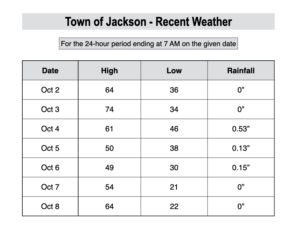
For perspective, the average high and low on October 8 in Jackson are 62º and 29º. However, averages are quickly decreasing at this time of year. By October 31, the average high and low drop to 49º and 22º.
Upcoming Weather Pattern
We are seeing an almost identical weather pattern this week compared to last week.
Beautiful sunny weather has returned during the middle part of this week with warmer daytime temperatures. Highs will reach the upper 60s on Wednesday and low 70s on Thursday – in all likelihood, our last 70-degree day of the year.
Unfortunately for weekend warriors, the weather pattern is going to flip again from Friday to Sunday with wet conditions expected.
First, a minor disturbance containing moisture from the remnants of Hurricane Priscilla in the Eastern Pacific will arrive from the southwest on Friday. This will result in more cloud cover and scattered showers, though temperatures will remain mild with highs well into the 60s.
The main storm system will then impact our area on Saturday and Sunday.
Off-and-on rain can be expected through the day on Saturday, with snow levels remaining high (above 10,000 feet) in the warm sector of the storm.
A cold front will then move through on Saturday evening with a round of heavier precipitation expected, along with falling snow levels as temperatures drop.
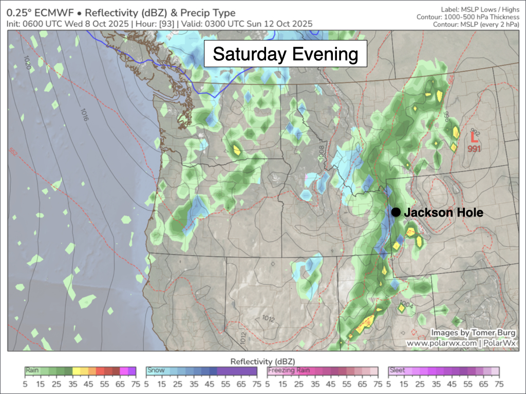
By early Sunday morning, the latest projections have snow levels dipping to the valley floor, including the town of Jackson.
Precipitation will be trending more showery and intermittent by first thing on Sunday morning, but there is a chance that the valley could see its first snow accumulation of the season, even if it ends up being on the lighter side.
Higher elevations will likely pick up a few inches or more of snow on Saturday night and Sunday, including Teton Pass, which could have a slick commute on Sunday morning.
Temperatures will remain chilly on Sunday with off-and-on rain/snow showers, but any low-elevation snow will melt off quickly.
A break in the pattern is likely on Monday, but then another storm could arrive as early as Tuesday with more rain and snow expected.
For now, the most likely scenario is that snow levels will stay above the valley floor during the middle of next week with low-elevation rain and high-elevation snow. But confidence is fairly low as models are in poor agreement in terms of temperature and snow levels.
Here is a 7-day precipitation projection from the European Ensemble Model, which represents the average of 50 simulations of this model.
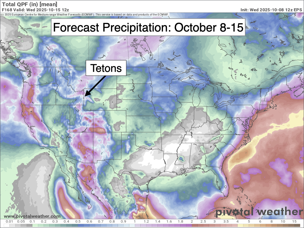
Looking further out, an active pattern is expected to continue late next week and possibly into the weekend of October 17-19.
Alan Smith, Meteorologist









