
JACKSON, Wyo. – Confidence is growing that a storm system will impact Western Wyoming from Friday to Sunday, bringing widespread rain and cooler temperatures. Snow is also possible on Teton Pass by Sunday morning.
Recent Weather and September Review
The past week has featured spectacular weather and peak fall colors. Sunny skies and highs well into the 70s were common late last week, though temperatures have been falling below freezing on clear nights.
The pattern was a bit more unsettled with increased cloud cover and spotty showers from Sunday to Tuesday. However, the system that moved through turned out to be fairly weak, and rainfall amounts have been light and spotty as a result.
The town of Jackson received only 0.06 inches of rain on Tuesday, with slightly higher amounts north of town and in the Teton Range from Teton Pass to JHMR. Rainfall was a bit heavier in Teton Valley on Tuesday, ranging from 0.2 to 0.4 inches.
Here is the 7-day weather summary in the town of Jackson:

The month of September ended up warmer and drier than average across Teton County, though rainfall was more abundant compared to mid-summer at least, which was a very dry season in our area this year.
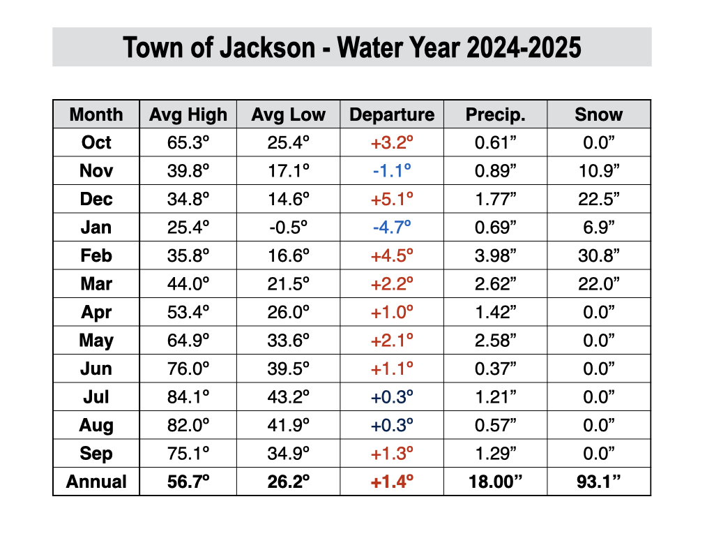
The town of Jackson ended up with 1.29 inches of rain in September, compared to the 2010-2024 average of 1.71 inches. Rain fell on 10 days during the month, and the highest 24-hour total was 0.37 inches on September 22.
The average high temperature in September 2025 was 75.1º and the average low temperature was 34.9º. Factoring in the high and low temperatures, September 2025 was 1.4º warmer than the 2010-2024 average.
The warmest temperature in September 2025 was 86º, which occurred twice on September 1 and 3, and the coldest temperature was 28º, which occurred on three separate days.
Upcoming Weather Pattern
A quiet weather pattern has returned during the middle part of this week, but big changes are heading our way this weekend.
First, we will see a bonus mild and sunny day on Thursday with highs reaching the low 70s in the valley. There are no guarantees that we will see another 70-degree day beyond Thursday, so enjoy it while you can.
Models are coming into better agreement that a stronger storm system will impact our area from Friday through Sunday, with a significant cool-down also expected on Saturday and Sunday.
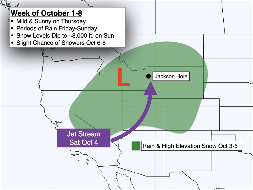
Friday morning should start out dry (just a slight chance of showers), then rain shower chances will increase on Friday afternoon as the system approaches.
Heavier and more widespread rain is expected from Friday night through the day on Saturday.
The town of Jackson and the lower valley could also see significant rainfall as winds will be blowing from the south, which is a favorable direction for town precipitation, as this minimizes the shadowing effect of the Teton Range.
Snow levels will start out high on Friday, around 11,000 feet or higher. On Saturday, snow levels will gradually lower to around 10,000 feet.
A cold front will move through sometime in the afternoon or evening on Saturday, with more terrain-driven (orographic) showers expected behind the front from Saturday night through Sunday that will favor the Tetons more so than the Jackson Hole Valley.
Snow levels will also continue to fall behind the front, possibly lowering to 8,000 or 7,500 feet by Sunday morning. This is low enough for snow to fall on Teton Pass, and some light slushy accumulations on the road couldn’t be ruled out first thing on Sunday morning, though any road accumulations should quickly melt as the day progresses.
Temperatures will also be noticeably cooler this weekend, with highs only in the low 50s in the valley on Saturday and Sunday, and 30s and 40s in the mountains. If you’re heading into the backcountry this weekend, be prepared for wet and cold conditions.
Here is a 7-day precipitation projection from the European Ensemble Model, which represents the average of 50 simulations of this model. Most of this will fall between Friday and Sunday.

Confidence in the weather forecast decreases significantly by early next week. Some models are projecting a drying trend that could last for a few days or more, while other models are projecting more storms to arrive shortly after the weekend storm.
For now, at least a brief break is likely at some point early next week, but after that is anyone’s guess until models come into better agreement.
Water Year 2025 Recap
The 2025 water year has just concluded, which starts on October 1 and runs through September 30.
Overall, the water year was warmer and drier than average in Teton County and across most of Wyoming. Drought conditions have taken hold across our region as a result.
Water Year 2025 Temperature Anomaly:

Water Year 2025 Precipitation Anomaly:

In the town of Jackson, 8 out of 12 months were at least 0.5º warmer than average, 2 months were at least 0.5º colder than average, and 2 months were within 0.5º of average.
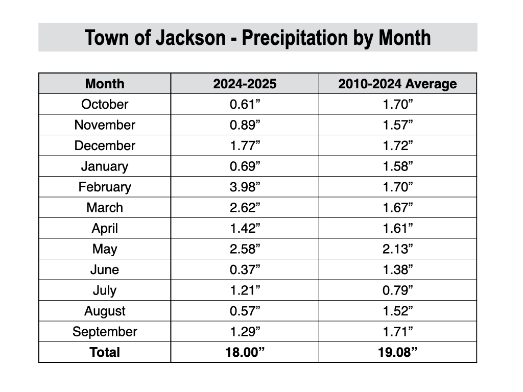
In terms of precipitation, the fall and early winter (Oct-Jan) were drier than average, late winter through spring (Feb-May) were wetter than average, and the summer (Jun-Sep) was drier than average.
In the town of Jackson, we ended up just over an inch below average (18.00 inches versus 19.08 inches), while discrepancies were higher elsewhere across the region.
For instance, Driggs only received 16.52 inches of precipitation in the water year 2025 compared to 18.00 inches in Jackson, even though historical averages are very similar in both locations.
For the winter of 2025-2026, we are likely heading into a weak La Niña. Last year, a weak La Niña was also predicted but did not quite materialize, and we ended up with neutral conditions instead.
Historically, La Niña winters tend to favor above-average winter snowfall in the Tetons, but it’s not a guarantee, as there are other oceanic-atmospheric signals that play a role, which are more challenging to predict months in advance.
Alan Smith, Meteorologist


