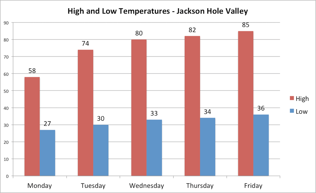
JACKSON, Wyo. — Much colder air has arrived behind Sunday’s cold front, bringing us an early taste of fall early this week as we close out the month of August. Temperatures dipped to around freezing in the Jackson Hole Valley on Monday morning, and increasing clouds will result in a chilly day with highs struggling to get out of the 50s.
Brief Cool Snap to Bring Freezing Temperatures and High Elevation Snowflakes
Following weeks of above-average warmth, a strong fall-like cold front arrived from the north on Sunday, ushering in a much colder airmass as we begin the week on Monday.
High temperatures on Monday afternoon will be about 15-20 degrees below average across Northwest Wyoming and the Northern Rockies.

Clouds are on the increase Monday morning as a disturbance approaches from the west/northwest. This disturbance will bring periods of light showers starting late this morning and continuing through the afternoon before clearing out on Monday evening.
Here is the satellite image showing the clouds moving in from the northwest on Monday morning.

Due to west/northwest winds aloft, precipitation amounts in the valley will be light, ranging from a trace to a tenth of an inch, while precipitation amounts in the mountains will range from about a tenth to a quarter of an inch.
As the colder airmass settles into place, we can also expect some snow to fall across the higher elevations on Monday. Snow levels could dip as low as 9,000 ft. on Monday afternoon, though minimal if any accumulations are expected at these elevations.
Across the higher peaks of the Tetons (above 10 or 11k), localized accumulations of an inch or two will be possible, so heads up if you have plans to climb the Grand or other high peaks on Tuesday. Here is a look at the webcam from the top of Jackson Hole Mountain Resort on Monday morning, where snow had already started to fall.

As skies clear on Monday night, a hard freeze is expected in the valley with lows falling into the upper 20s. The National Weather Service in Riverton has issued a Freeze Warning for the Jackson Hole Valley from 2-9 a.m. on Tuesday.
Return to Summer-Like Temperatures Later this Week
The cool snap early this week will be brief as high pressure builds back in from the west starting on Tuesday, leading to much warmer temperatures as the week progresses. From Wednesday through the end of the week, temperatures will be above average with valley highs in the 80s, though nights/mornings will continue to be chilly as we see large swings between day and night.
Looking farther ahead to Labor Day weekend, Saturday will be the warmest day with highs expected to reach the mid-80s or higher in the valley. A weak cold front is then projected to arrive on Sunday, followed by a stronger cold front on Monday. This will lead to a gradual cooling trend, with highs expected to be in the 70s for Labor Day Monday.
Dry conditions are expected from Tuesday of this week through Labor Day weekend, making it an excellent time to get outdoors and enjoy summer activities while we still can.
Wildfire and Smoke Updates
A shift in winds aloft will keep the California wildfire smoke away from Jackson Hole for the foreseeable future, but fire activity has picked up locally and across Idaho.
On Sunday, two new fires were reported: the Smoky Hollow Fire near Mosquito Creek in the Snake River Range (10 acres) and the Shoal Creek fire near Bondurant (25 acres).
The cooler and wetter conditions on Monday will temporarily reduce the risk of fire spread and new fire potential, but then we’ll see a return to warm and very dry conditions. Winds will be lighter this week compared to recent days, but we could still see breezy conditions at times, mainly on Monday and again on Wednesday and Thursday.
Occasional periods of smoke and haze will be possible this week due to the new fires locally as well as from the Bear Creek Fire along the Idaho/Montana border that has consumed more than 11,000 acres.
August Review and September Outlook
Although we aren’t quite finished with August, we can go ahead and conclude that it has been a very hot and dry month by our standards despite the much cooler final day of the month.
Through August 30, temperatures at the Jackson Hole Airport have been 2.9 degrees warmer than average for the month of August.
We finally broke our August dry streak and picked up some rainfall last week, but overall the month has still been much drier than average. The town of Jackson has only recorded 0.24 inches of rain through August 30, compared to a long-term average of 1.40 inches.
The outlook for September is also for warmer and drier than average conditions. Through mid-September, rain chances look marginal at best with generally warm temperatures expected aside from the occasional brief cool snaps. Even on warm days at this time of the year, however, nighttime valley temperatures will be very chilly.
There aren’t any signs of significant weather systems on the horizon through at least mid-September. Beyond mid-September, odds are we will see at least one cool and wet system arrive at some point based on historical climatology.
Alan Smith, Meteorologist