


JACKSON, Wyo. – A significant warm-up will occur late this week with highs reaching the upper 60s to near 70º in the valley on Friday. A storm system will arrive over the weekend with rain and snow showers and colder temperatures, but only light snowfall is expected.
March 2025 Recap
A snowy March has given way to a quiet start to April as winter seems to be quickly fading.
March was an active month with above-average precipitation and snowfall, while temperatures were also above average.
The Rendezvous Bowl Plot at Jackson Hole Mountain Resort received 86 inches of snow in March, which is above its long-term March average of 67 inches.
The town of Jackson received 20.4 inches of snow in March, which is above its long-term March average of 13.7 inches. Jackson also received 2.62 inches of precipitation in March, which is above its long-term average of 1.67 inches.
Season-to-date snowfall totals as of April 9 include 445 inches at Jackson Hole’s Rendezvous Bowl Plot, 359 inches at Jackson Hole’s Mid-Mountain Plot, 435 inches at Grand Targhee’s Chief Joseph Bowl Plot, and 91.5 inches in the town of Jackson.
March was 2.2ºF warmer than normal in the town of Jackson. The average high in March 2025 was 44.0ºF and the average low was 21.5ºF, compared to a 15-year (2010-2024) high and low of 42.2ºF and 18.8ºF.
The warmest temperature of the month was 62ºF on March 27 and the coldest temperature of the month was -2ºF on March 19.
Recent Weather Conditions
The first three days of April were winter-like with snow totals ranging from 6-12 inches in the Tetons above 8,000 feet, while the town of Jackson only received trace amounts.
Chilly temperatures prevailed through the first four days of the month with highs in the 30s and 40s in town, but we have seen progressively warmer temperatures over the past four days with highs in the 50s.
Conditions have also dried out significantly since the first few days of the month with only some light showers.
Snowpack was 111% of average in the Snake River Headwaters Basin (which includes the Tetons) heading into early April. However, due to current (and upcoming) dry weather along with warmer temperatures, we are beginning to see a sharp decline in snowpack due to melting.
As of April 9, snowpack remains 104% of average, but looking at the black line, we can already see a sharp decline just over the past couple of days.

Upcoming Weather Pattern
A strong ridge of high pressure will build over the Western U.S. late this week and we will see our warmest temperatures since October on Thursday and Friday. On Thursday, highs will reach the mid 60s in the valley, and on Friday, highs will reach the upper 60s to near 70º. The average high at this time of year is around 50º for perspective.
This is not expected to be record-challenging warmth, as the record high on Friday is 75ºF. However, if we do manage to hit 70º in town, it would be the first 70º reading in the month of April since 2020.
We often see large fluctuations in temperature at this time of year, and the next week will be no different. Over the weekend, a storm system will move across the Northern Rockies with a cold front pushing through our area on Saturday night.
During the day on Saturday, rain showers will develop and snow levels (the rain/snow line) will be quite high with a mild airmass remaining in place. Snow levels will range from 8,000-9,000 feet for most of Saturday but could potentially reach as high as 10,000 feet.
Once the cold front moves through on Saturday night, snow levels will plummet to the valley floor. However, only light snowfall is expected behind the cold front. Snowfall will be heavier further north in Montana.
Highs will reach the upper 50s in the valley on Saturday. Temperatures will be much colder on Sunday with lows starting out in the 20s and highs only reaching the upper 30s to low 40s.
Dry conditions will return early next week with high temperatures likely reaching 60 or above in Jackson by Tuesday.
Other than the weekend showers, the pattern over the next week will continue to be drier than usual for our area and across much of the Western U.S. with heavier snowfall to the north in Canada, and over the Northeast U.S.
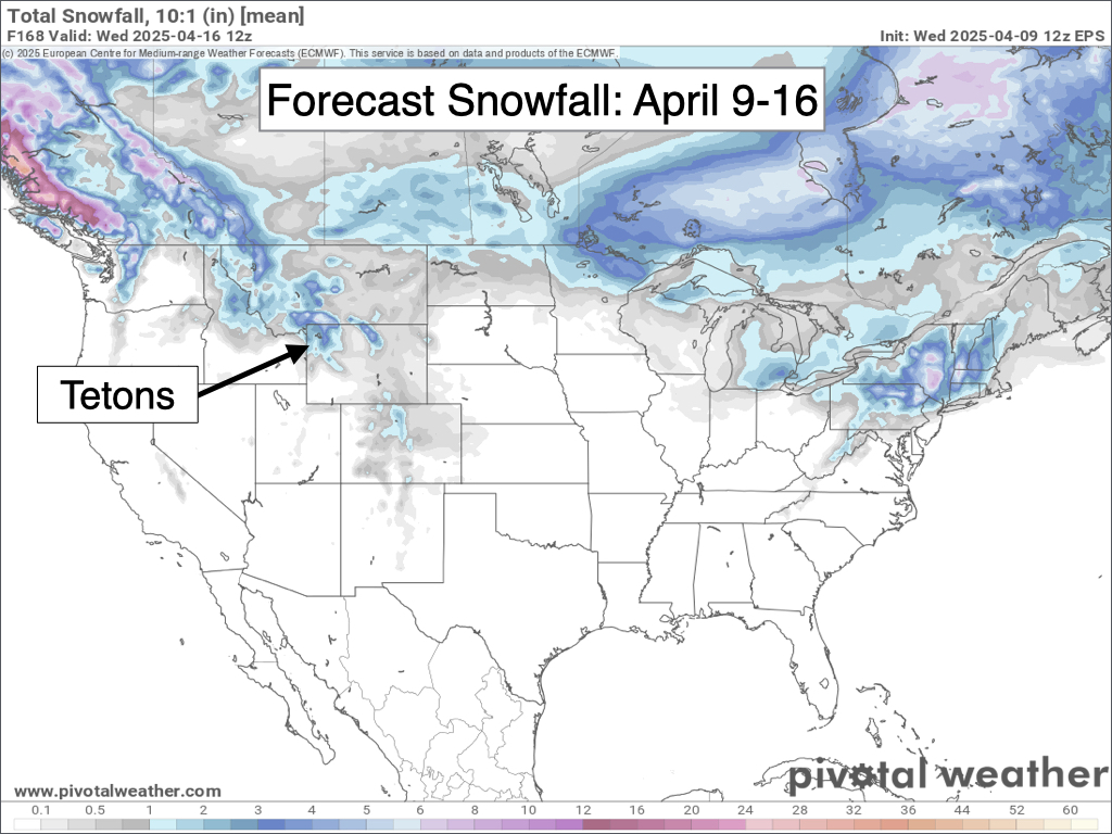
Looking further out, conditions are expected to be warmer and drier than normal from April 17-23 as high pressure continues to dominate the pattern in the Western U.S.

We could certainly see an occasional cold front or storm sneak in, but overall, this is shaping up to be a quieter-than-usual April.
Alan Smith, Meteorologist










