


JACKSON, Wyo. – August was warmer than average and wetter than average for most of the region, with monthly rain totals of around 3 inches in Jackson and 3-6 inches across the higher elevations. September is expected to be fairly active as well with above-average precipitation and near-average temperatures favored.
Recent Weather Pattern
Last week started out with warm and dry conditions, before transitioning to a cooler and wetter pattern over the weekend.
High temperatures pushed into the mid 80s from Tuesday to Thursday of last week, and based on the outlook ahead, it’s possible we may have seen our last 85+ degree temperatures of the year.
Between Friday morning and Sunday morning, a trough of low pressure impacted the area, bringing cooler temperatures and moisture from the remnants of tropical activity in the Eastern Pacific.
The showers and thunderstorms came in intermittent bursts, with the heaviest and most widespread rainfall occurring on Friday night and Saturday morning, followed by hit-or-miss scattered thunderstorms from Saturday afternoon through Sunday morning.
Rain totals from Friday to Sunday generally ranged from 0.8 to 1.5 inches above 8,000 feet and 0.3 to 1.0 inches in the valleys, including 0.6 inches in the town of Jackson.
High temperatures only reached the upper 60s to near 70 from Friday to Sunday. As skies cleared out on Sunday afternoon, breezy winds and comfortable temperatures brought fall vibes to the valley.
And on Monday morning, we woke up to our first freeze of this season in the valley with a low of 30ºF in Jackson and a low of 28ºF at the Jackson Hole Airport. The average first freeze in the valley is in late August, so this was pretty close to climatology.
Here is the 7-day weather summary for the town of Jackson:

For perspective, the average high and low temperatures in Jackson on August 31 are 78º and 39º.
August 2026 Review
The first 10 days of August were dry on the heels of a relatively active July, but the pattern during the final 3 weeks of August more than made up for it with wetter-than-average conditions.
A consistent southwest flow brought several “surges” of moisture from the Southwest Monsoon into our area, and a series of low pressure troughs approaching from the West Coast helped to trigger showers and thunderstorms with several stretches producing significant rainfall.
Most of the Greater Teton Region, Western Wyoming, and Eastern Idaho ended up with above-average rainfall in August, though a few areas such as Driggs and the Northern JH Valley had near to slightly below average rain, which happens sometimes due to the hit or miss nature of summer thunderstorms.
But for the region as a whole, it was a productive month for rain. Both July and August have been wetter than average for the region overall, which has contributed to a quiet fire season locally, unlike many other parts of the West.

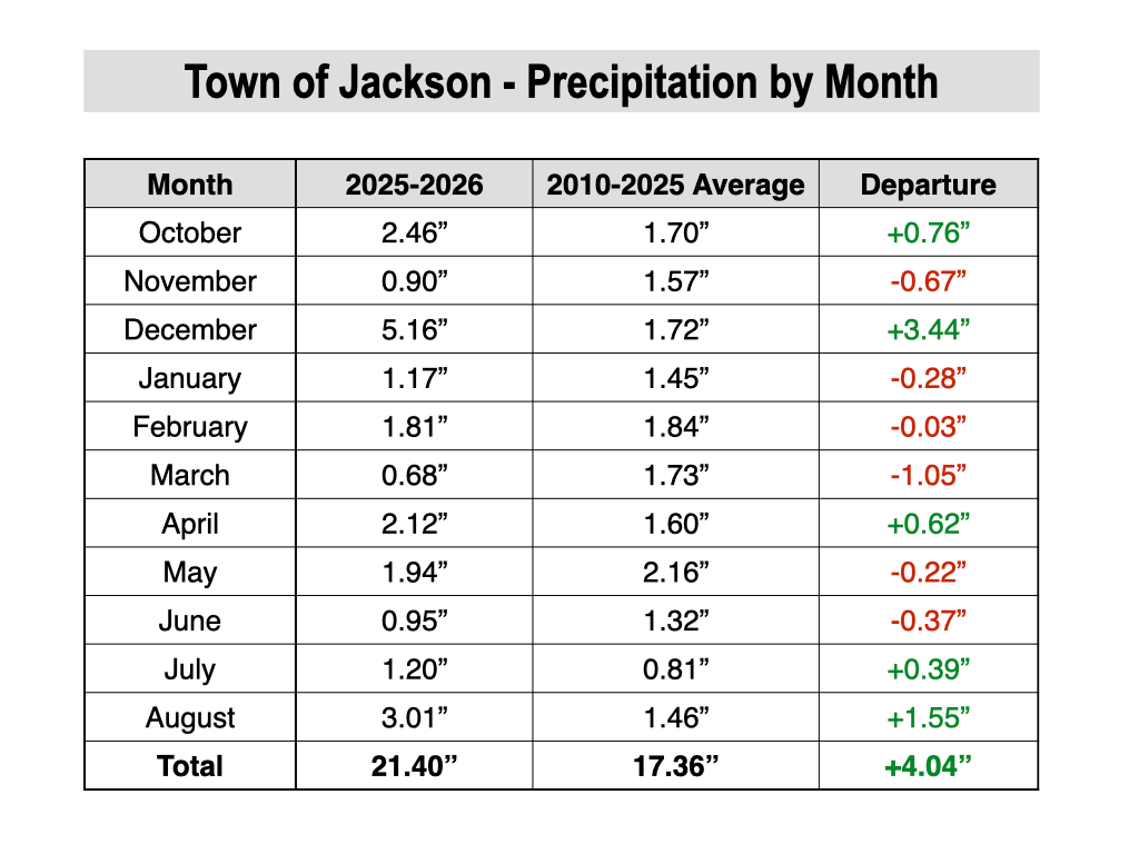
The town of Jackson finished with 3.01 inches of rain during August, the wettest month in town since last December, and the wettest August since 2023.
For the water year as a whole (since October 1st), precipitation is now 4 inches above average in the town of Jackson, despite having a poor winter for snowfall.
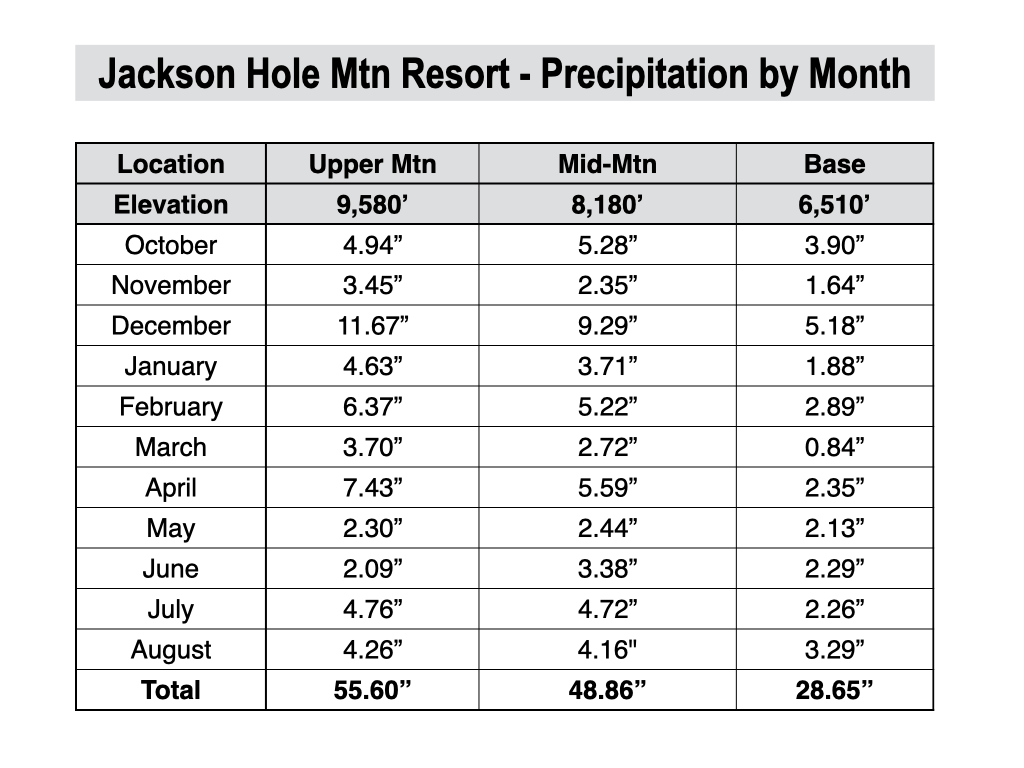
The mountains also have another impressive rainfall month, with totals including 4 to 5 inches at Jackson Hole Mountain Resort, 3.8 inches at Grand Targhee, 5.67 inches at Mt. Baird in the Snake River Range, and 3.56 inches at Togwotee Mountain Lodge.
The next chart shows precipitation by month since October for the upper mountain, mid-mountain, and base area plots at Jackson Hole Mountain Resort.
Temperatures were also above average in August and we have several brief heat waves, but it was never quite as hot as what we experienced in July. We also had several stretches of cooler weather.
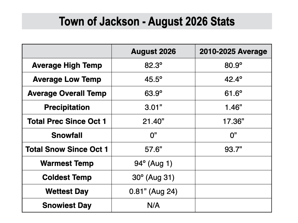
For the month as a whole, temperatures ended up 2.3ºF above average in the town of Jackson, based on 2010-2025 data from the JKNW4 weather station.
There were 6 days with highs in the 90s in Jackson, bringing the yearly total to 14 days with highs in the 90s which is three times the number of 90 degree days we see in average year (the 2010-2025 average is 4.6 days).
However, the heat was never as consistent as what we had in July. We also had three days in August in which highs were only in the 60s, and we had a few mornings with lows in the 30s early and late in the month.
For the U.S. as a whole, temperatures were above-average in August across most of the country, with significant anomalies just to our south and southwest.

Here is a look at the August weather stats for the town of Jackson.
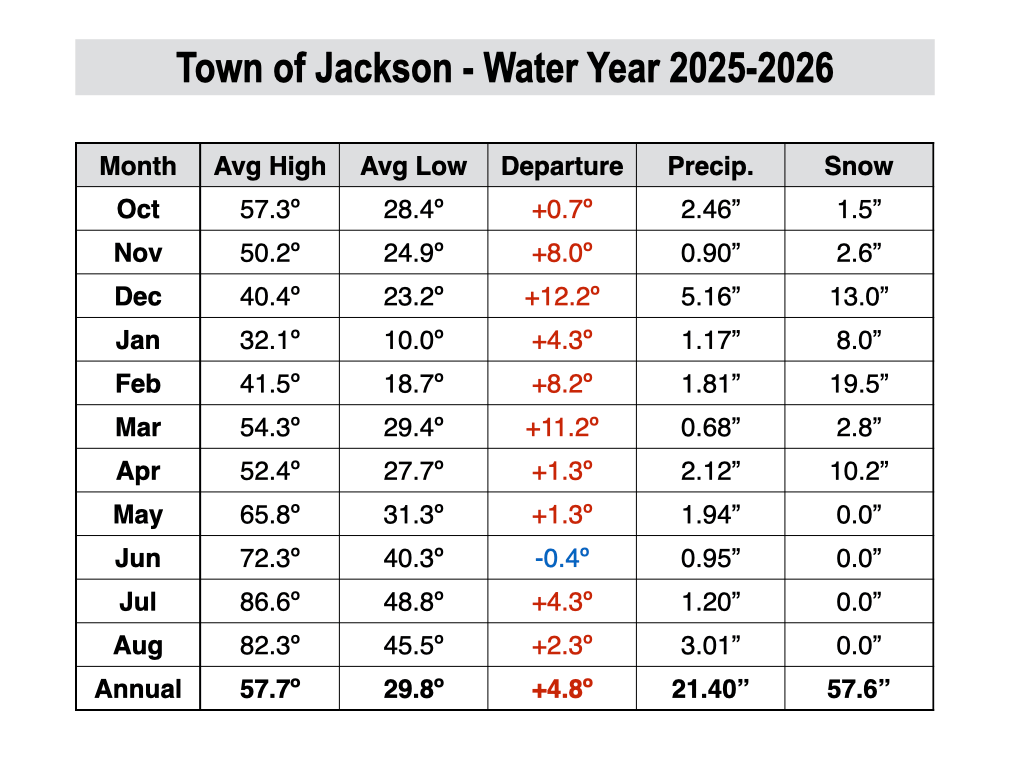
The next chart shows the monthly temperature averages and precipitation and snow totals Jackson since the start of the water year on October 1st. The “departure” column indicates the departure from average temperature when factoring in the average highs and lows.
Upcoming Weather Pattern
The first week of September through Labor Day is expected to feature a mix of beautiful early fall weather with stretches of more unsettled weather including showers and thunderstorms.
Following a nice start to the week on Monday, a shortwave trough will arrive on Tuesday along with another surge of monsoonal moisture.
This will bring a good chance of showers (widespread coverage possible) prior to sunrise on Tuesday through mid to late morning, followed by more intermittent showers and thunderstorms in the afternoon. Locally heavy rain will be possible in this setup.
Showers and thunderstorms could potentially linger late into the evening on Tuesday, then we will head back into a nice weather pattern on Wednesday and Thursday with mostly sunny skies and highs in the 70s.
Heading into Labor Day weekend, the pattern looks to turn more unsettled again though confidence in the day-to-day details is low this far out.
A trough of low pressure is expected to set up over the Pacific Northwest, while a ridge of high pressure will build just east of the Rockies. In between these features, a south/southwest flow will likely bring some monsoonal moisture back into our area, resulting in at least a chance of showers and thunderstorms.
The biggest question mark is whether or not moisture from a tropical storm in the Eastern Pacific feeds into the monsoonal flow, which could mean the difference between isolated afternoon thunderstorms on some days, versus more cloud cover and potentially more widespread activity.
For now, plan on at least a chance of showers and thunderstorms over the holiday weekend, and keep an eye on the forecast as we get closer.
The 7-day precipitation projection below represents the average of 50 simulations of the European weather model. Notice how we are just in between heavier precipitation projections over the PNW and also over the Southern Rockies from the monsoon, which indicates some uncertainty as to how exactly this will play out.
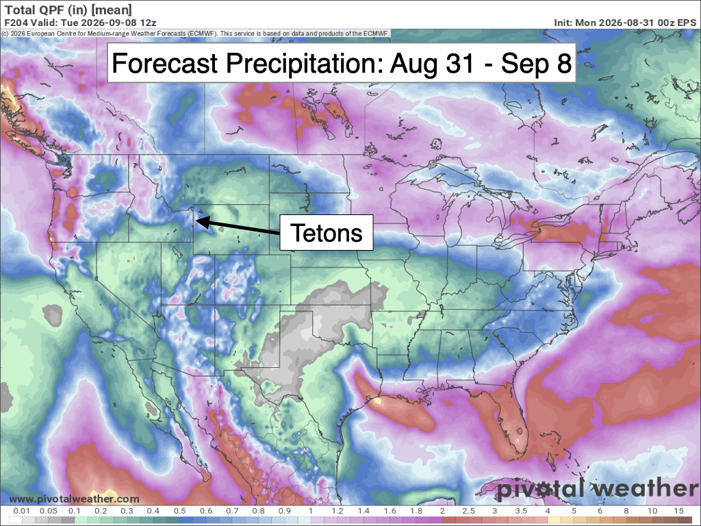
In terms of temperatures, the PNW trough is projected to remain far enough west through the holiday weekend to prevent any major shots of chilly air from reaching our area.
For now, we are projected to have highs in the 70s each day through the holiday weekend, but keep in mind these details could also change as we get closer depending on moisture/cloud cover and any smaller scale disturbances.
September Outlook
September is a transition month in the Tetons between summer and autumn, and is arguably the nicest month of the year with comfortable temperatures and more stable weather patterns common.
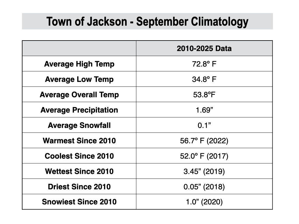
September is the fourth warmest month of the year in Jackson with an average high of 72.8º and an average low of 34.8º. Freezing overnight temperatures become more common as the month progresses during periods of clear weather.
High temperatures in the 80s are not uncommon early in the month, but become much less likely by mid to late month. Highs of 90 and above are rare in September, but it has happened as recently as 2022.
Average precipitation in September is higher compared to the summer months, and substantial rain events sometimes happen. However, rainfall tends to be more concentrated in a smaller number of days, with extended stretches of dry and sunny conditions also common.
Average precipitation in September in the town of Jackson is 1.69 inches, but actual amounts vary substantially from year to year. For example, in 2018, Jackson received only 0.05 inches of rain in September, but in 2019, Jackson received 3.45 inches of rain in September.
As temperatures trend colder with the changing seasons, the Teton Mountains often receive their first widespread snow event of the season in September, though it usually doesn’t hang around for long except on the shaded aspects of the high peaks.
Accumulating snowfall in the town of Jackson is rare in September, but it happened as recently as 2020 when an inch of snow fell in town.
For September 2026, the pattern is looking somewhat more active than usual with troughs expected to move into the Western U.S. more regularly, at least during the first half of the month, while the Southwest Monsoon is also still alive, at least for a little while longer.
Longer-range models are generally favoring above-average precipitation for our area this September while temperatures are not expected to deviate much from average.
We should still see some nice stretches of weather this month, even if we get some occasional wet periods, while the potential for late season heatwaves also looks minimal at this point.
Alan Smith, Meteorologist











