


JACKSON, Wyo. – A robust disturbance will move across the area on Wednesday, which will trigger strong to severe thunderstorms with frequent lightning, strong winds, large hail, and heavy rain possible. The pattern will then dry out beyond Wednesday with limited rainfall potential through late June.
Wednesday Outlook
A shortwave trough will track across the Northern Rockies during the day on Wednesday, resulting in an uptick in moisture, vertical lift, and wind shear (change in wind speed/direction with height).
The atmosphere will also become very unstable due to the uptick in moisture combined with steep lapse rates (rate of temperature decrease with altitude), which will support widespread thunderstorms on Wednesday afternoon, along with the potential for severe thunderstorms.
There is a slight chance of lightning before noon on Wednesday, as we are already seeing some hints of development across Eastern Idaho as of 8:15 a.m., but the best chance of thunderstorms will be from about noon to 9 p.m.
Within this window, the best chance of strong to severe thunderstorms will be from about 3 p.m. to 7 p.m. during peak afternoon heating.
Storms will be capable of producing frequent cloud-to-ground lightning, and storms will also be fast-moving from the west/southwest to east/northeast, so prepare accordingly if you have outdoor activities planned today.
The most notable severe weather threat will be wind, with the potential for thunderstorm outflow wind gusts of 50-70 mph with stronger clusters of storms, which could cause damage.
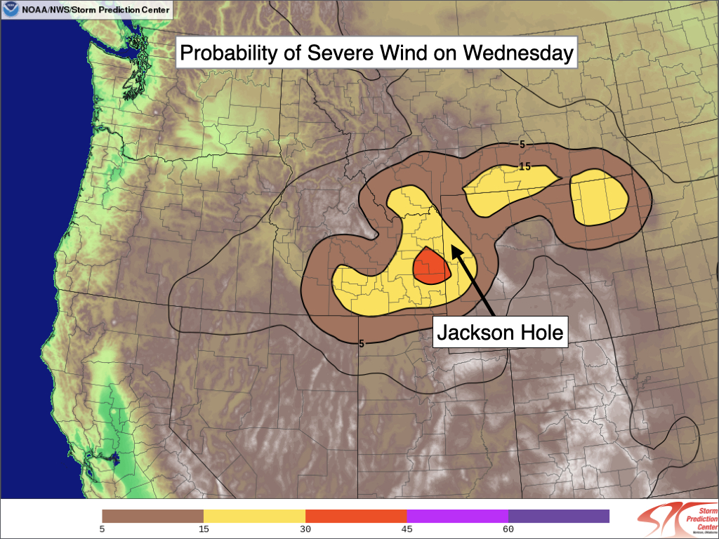
To qualify as “severe” based solely on wind per the National Weather Service (NWS), a wind gust must reach a speed of 58 mph or higher or cause notable damage. The NWS Storm Prediction Center’s model has a 15% chance of severe-level winds for most of the area on Wednesday, with a 30% risk area noted to the southwest over Swan Valley.
There is also potential for late afternoon thunderstorms to produce isolated large hail, ranging from marble size (half-inch diameter) to quarter size (one-inch diameter) or larger. Quarter-size hail is large enough to cause damage to plants and property and is the minimum criterion to qualify a storm as “severe” based on hail.
Heavy rainfall is also possible with storms today. Rainfall amounts are always variable in thunderstorm setups, but most locations are expected to receive rainfall amounts of 0.1 to 0.5 inches, with isolated higher amounts possible.
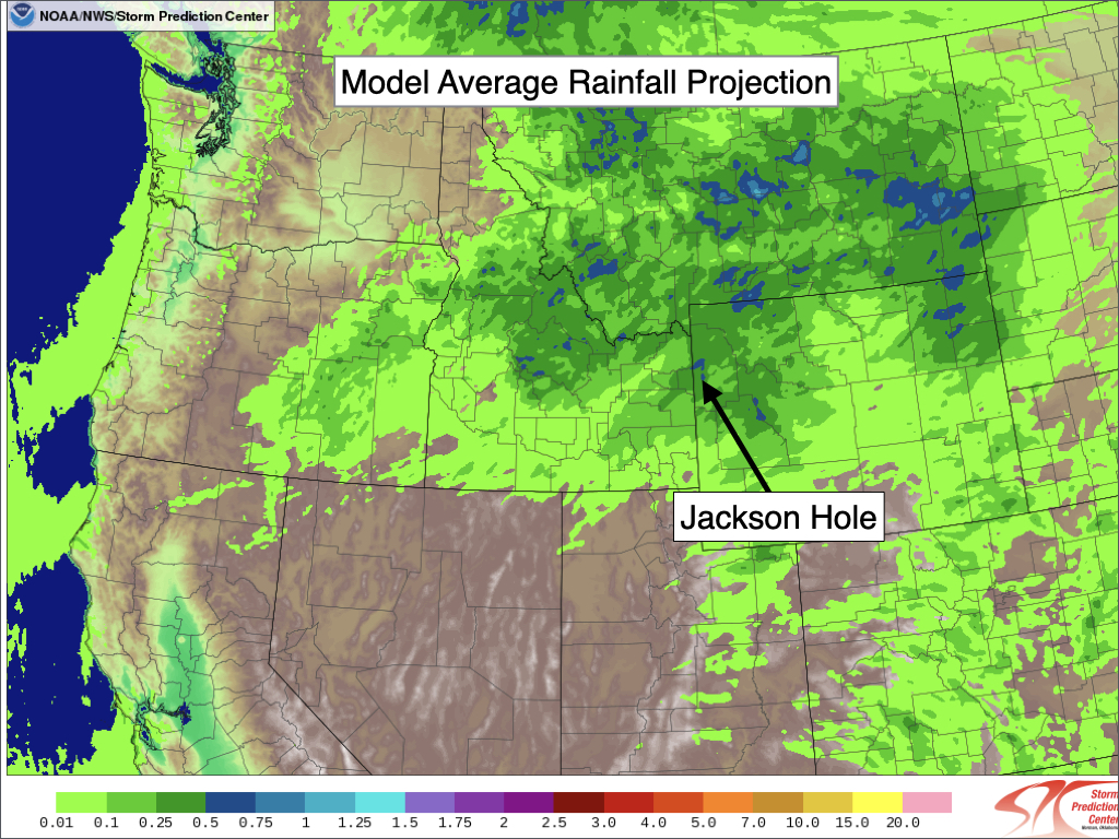
In terms of isolated higher totals, strong thunderstorms or training of thunderstorms could produce locally heavy rainfall amounts of 0.5 to 1.2 inches or more. If some of these higher rainfall amounts are realized in a short period of time, it could pose a risk of localized flash flooding.
Thunderstorm activity should wind down by early evening with the loss of daytime heating as the shortwave tracks east of the area.
Extended Outlook
This looks like it will be a one-and-done event before we revert back to a much drier weather pattern.
On Thursday, another disturbance will approach late in the day, which could trigger some late afternoon or evening thunderstorms. However, it is more of a conditional threat as a capping inversion in the middle of the atmosphere could act as an inhibitor to thunderstorm development.
If storms do form, they will produce lighter rainfall compared to Wednesday and will not be as intense overall.
Starting on Friday and continuing into next week, disturbances will continue to pass north of our area – just a bit too far north for us to see much more than gusty winds and occasional isolated thunderstorm chances.
Overall, rainfall potential looks low for the next two weeks after today.
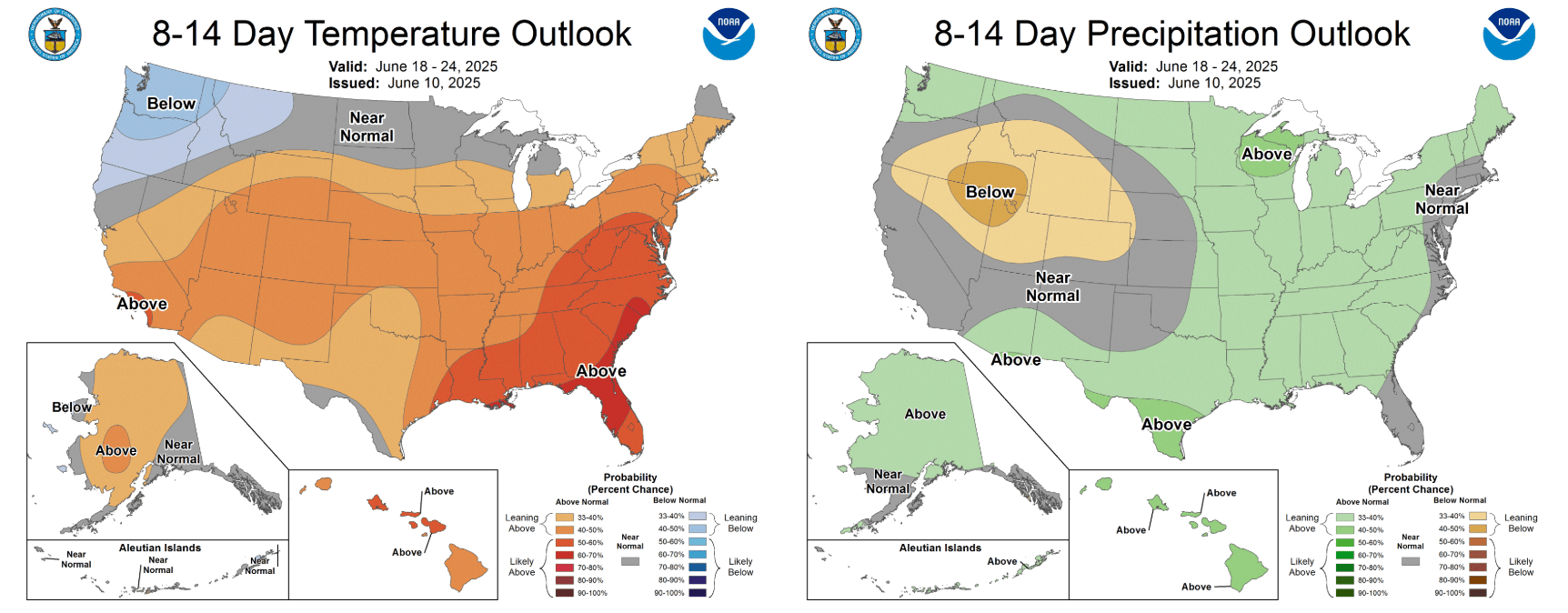
NOAA’s Climate Prediction Center is projecting warmer and drier than normal conditions across our region heading into late June.
Alan Smith, Meteorologist










