
JACKSON, Wyo. – Temperatures have been unseasonably warm in Jackson Hole over the past two weeks with only light snowfall. The pattern is expected to turn more active during the first 7-10 days of February with several opportunities for snow.
Recent Weather and January Recap
We experienced about two weeks of what felt like a true Jackson Hole winter from January 4-17 with frequent heavy snow and cold temperatures. Since that time, we have headed right back into a mild spell with consistent above-average temperatures and only light snow.
Last week, we saw consistent cloud cover with periods of light snow despite the warmth as the remnants of weak storms hitting the west coast made it all the way to Western Wyoming on a regular basis.
Early this week, high pressure has strengthened over the area, resulting in further warming along with abundant sunshine in the Tetons. High temperatures have been in the 30s to 40s in the 8,000-10,000 foot range, which is well above average for late January.
Weak inversions have kept temperatures slightly cooler in the valley, but it has been mild at all elevations.
Low clouds have been prevalent in the Jackson Hole Valley in part due to the inversion, and this stubborn cloud cover has been slow to erode in the afternoons.
Above-freezing temperatures have led to snowmelt in the valley each day, and this moisture then cools and condenses into low clouds at night, with a stable airmass keeping the cloud layer confined to the low elevations.

For the month of January, temperatures in Jackson will end up 3.4ºF above normal with an average high of 30.7ºF and an average low of 9.5ºF. The normal high and low in January are 28.3ºF and 5.0ºF.
The warmest temperature this month was 44ºF on January 22 and the coldest of the month was -25ºF on January 16. Another way of looking at this is that we saw a 69ºF temperature swing in less than a week.
After recording high temperatures of 10ºF on January 15 and 11ºF on January 16, the temperature rose above freezing on 14 of the final 15 days of the month from January 17-31.
In terms of snowfall, it depends on the location as to whether January 2024 was an above or below-average month.
Snowfall at Jackson Hole Mountain Resort was below average in January with 73 inches recorded at the Rendezvous Bowl Plot, compared to a 30-year average of 90 inches.
Snowfall at Grand Targhee was slightly above average, with 85 inches recorded at the Chief Joseph Bowl Plot compared to an average of 82 inches.
Despite the melting that occurred late in the month, snowfall in the Town of Jackson was above average in January with a total of 25.9 inches recorded (Cocorahs WY-TT-40) compared to an average of 19 inches.
Precipitation was also above average in Jackson in January, with a total of 2.43 inches recorded compared to the January average of 1.28 inches.
Here is a look at monthly and season-to-date snow totals across the area. Despite the slow finish to the month, January snowfall was much better compared to prior months.

Snowpack as measured by snow depth (the height of the snow on the ground) is well below average in the Tetons and in the Jackson Hole Valley. So far, this has been one of our lightest winters in the past 15-20 years, though we still have February and March to go so we’ll see how the rest of this winter shakes out.
Here are the current snow depths across the area:

In terms of snow water equivalent (the water content of the snowpack), the snowpack in our region is about 76% of average, and this includes the Teton Range, Gros Ventre Range, Southern Yellowstone, Northern Greys River Region, and the Snake River Range.

Upcoming Weather Pattern
Warm temperatures will prevail through Thursday and Friday, but the weather pattern will start to change this weekend and next week.
Cloud cover will be on the increase on Thursday and Friday and light showers are possible on Friday as moisture arrives from the south. Temperatures will still be mild during this early stage, so any precipitation may fall as rain or a rain/snow mix in the valley.
The dominant storm track will favor the Southwest U.S. late this week with the jet stream located near the U.S./Mexico border. However, moisture will still manage to reach the Northern Rockies and winds will shift from southerly to westerly on Saturday, which is a favorable direction for terrain-enhanced snowfall over the Tetons.
Therefore, more widespread snowfall is expected from Saturday into Sunday with temperatures also trending colder. For now, the expectation is for moderate snow accumulations in the Tetons but there is some uncertainty as this is an atypical weather pattern for Teton snowfall.
Light accumulations are also possible in the Jackson Hole Valley this weekend as precipitation type will change from mixed precipitation to snow on Saturday as colder air arrives.
Next week (starting Monday, February 5), the pattern is looking more favorable for Teton snowfall as a series of storms will move across California and approach our area from the southwest.
The storm track looks to be a little further north with this pattern early next week, which should place the Tetons under a stronger and more favorable southwest flow with a few rounds of snow possible.
Here is a 7-day snowfall projection through Wednesday, February 6:
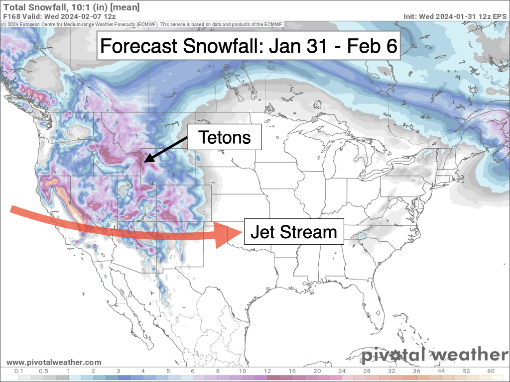
Temperatures will be closer to seasonal averages during this period, but highs are still expected to reach the 30s in the valley each day. Snow quality/density will likely fluctuate in the Tetons with each storm, with wet snow quality more likely in the valley.
Looking further out, an unsettled pattern is expected to continue heading into the weekend of February 10-11, then longer range models are indicating that high pressure may build over the Western U.S. heading into mid-February, which would send us into a drier pattern.
Alan Smith, Meteorologist


