


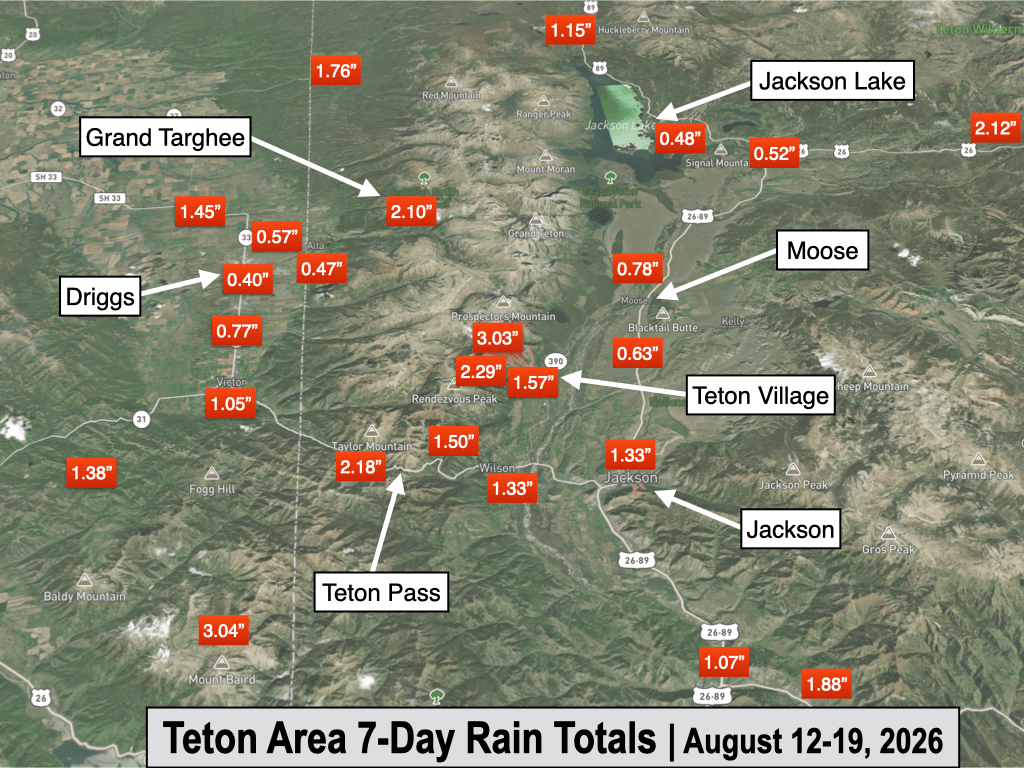
JACKSON, Wyo. – Over the past week, a cooler and wetter pattern took hold with 7-day rain totals ranging from 1.5 to 3 inches in the Tetons and 0.5 to 1.5 inches in the Jackson Hole Valley, including 1.33 inches in the town of Jackson. A brief hot and dry spell late this week will give way to increasing moisture with scattered showers and thunderstorms this weekend.
Recent Weather Pattern
The last week featured a significant change to the weather pattern, putting an end to a 5-week stretch of well above average warmth.
The Southwest Monsoon also intensified, sending moisture northward into Wyoming and contributing to significant rain totals, especially in the mountains and Lower Jackson Hole Valley.
A Pacific trough of low pressure moved into the area late last week, bringing much cooler air, while south to southwest winds associated with the trough helped to pull in subtropical moisture associated with the monsoon.
On Thursday, the town of Jackson recorded a high of only 62ºF and also picked up 0.47 inches of rain on what felt more like an autumn day. This was the wettest day in town since May 30, although in the Tetons, there were single days with higher rain totals in late July.
The cool and wet pattern prevailed on Friday and Saturday with additional showers and thunderstorms that produced substantial rainfall for much of the area.
The pattern warmed up some from Sunday to Tuesday, but we still saw rounds of showers and thunderstorms in the area each day, including a cluster of early morning thunderstorms on Tuesday.
The town of Jackson recorded measurable rainfall on seven consecutive days for a total of 1.33 inches of rain, while rain gauges in the Tetons and surrounding ranges received as much as 2 to 3 inches of rain over this same period. Totals were a bit lower in the Northern Jackson Hole Valley and around Driggs and Alta.
Over the past 7 days, Jackson only had a high of 80ºF or higher on two days, while there were also two days with highs only in the 60s.
Compare this to the preceding stretch from July 4 to August 12 when Jackson hit 80ºF or higher on all but one day, a stretch of 39 out of 40 days (and the one day the high was below 80ºF, it was barely so with a high of 79ºF).
Here is the 7-day weather summary for the town of Jackson:
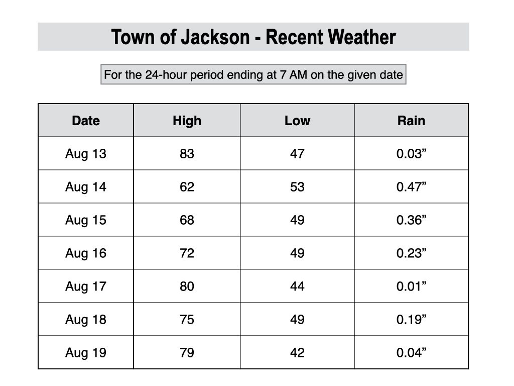
For perspective, the average high and low temperatures in Jackson on August 19 are 80º and 42º.
Upcoming Weather Pattern
We are getting a break in the monsoonal flow over the next couple of days as drier air has worked its way in, while a ridge of high pressure is also building in from the south.
This building ridge will lead to a return of hot afternoon temperatures over the next few days, with highs topping out around 90ºF in the valley on Thursday and Friday. However, this heat wave will be short-lived unlike what we saw for most of July and early August.
On Friday night and Saturday, another low pressure trough will approach and will help to drive in a surge of monsoonal moisture. This will lead to an uptick in showers and thunderstorms on Saturday and Sunday, including a threat of morning lightning activity, though the highest coverage is still expected in the afternoon.
Temperatures will not cool down to the extent of what we saw last week, but they will cool off from Thursday-Friday’s levels, with highs over the weekend and into early next week generally ranging from the upper 70s to low 80s.
It looks like we will hang onto a monsoonal flow through the first half of next week as well (Monday to Wednesday), with scattered afternoon thunderstorms expected.
The image below is a 7-day rainfall projection, representing the average of 50 simulations of the European Model. While not as wet of a signal as last week’s monsoon moisture surge, this is still a good signal for meaningful rain.
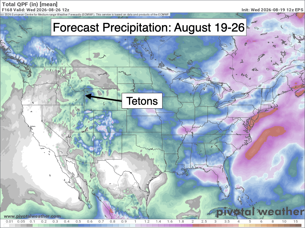
Last week’s rainfall plus the outlook over the next seven days have us on track to see an above-average precipitation month for August, though it may be tough to approach the levels we saw in August 2022 and 2023, which were both very wet months (over 3 inches of rain in Jackson).
Looking ahead to the final days of August (beyond the 26th), confidence in the forecast decreases substantially with some models favoring a gradual drying trend, while other models are projecting another uptick in moisture.
In terms of temperature, no heat waves are anticipated beyond Thursday-Friday through the end of the month. Next week, we should run near to slightly above average, while there are some hints of a possible cooling trend around the end of the month, with the caveat that confidence is low this far out.
Alan Smith, Meteorologist











