


JACKSON, Wyo. – July 2026 was the hottest month in Jackson in nearly 20 years, but moisture from the Southwest Monsoon during the second half of the month contributed to above-average rainfall. August is off to a dry and smoky start, with moisture expected to return around mid-month.
Recent Weather Pattern
The weather pattern has been more variable over the past week, compared to prior weeks when it was just consistently hot.
During the middle part of last week, many areas picked up some good rainfall from showers and thunderstorms during the latter stages of a monsoonal flow pattern.
Last Wednesday evening was the wettest period, when the town of Jackson received a quarter-inch of rain, and the Teton Range picked up 0.4 to 0.8 inches of rain.
Our final day of the active thunderstorm pattern was on Friday. Unfortunately, lightning triggered the Big Rock Fire on the west side of the Big Hole Range, an area that has been drier recently compared to Teton County.
Over the weekend, we saw another heat wave, but it was brief, with a high of 94ºF in Jackson on Saturday. This was the only day in the past week with a high temperature of 90ºF or above, but it was our ninth day of the summer with a high in the 90s.
For perspective, from 2010 to 2025, the town of Jackson averaged 4.6 days of 90+ degree high temperatures per year.
Much drier air also pushed into the area on Saturday as the Southwest Monsoon weakened, with moisture retreating well southward.
On Sunday, heavy smoke rolled into the area from the Big Rock Fire in Idaho, leading to poor visibility and poor air quality. Winds also increased ahead of an approaching cold front.
As the front moved through early on Monday, we saw a refreshing cool-down with highs in the upper 70s to near 80 on Monday and Tuesday, while overnight lows dipped well into the 30s. These were the first below-average temperature days in Jackson since July 4.
Since Sunday, the Big Rock Fire has not been burning as intensely or producing as much smoke compared to the weekend. However, west/northwest winds in the upper atmosphere have brought smoke into our area from wildfires burning in Washington, Oregon, and Western Idaho.
Smoke levels and air quality have been fluctuating quite a bit, but so far it hasn’t been as bad compared to Sunday when smoke was much heavier.
Here is the 7-day weather summary for the town of Jackson:
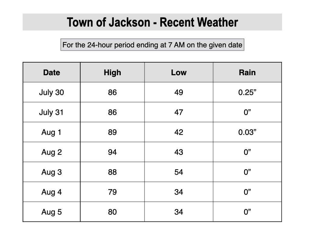
For perspective, the average high and low temperatures in Jackson on August 5 are 83º and 44º.
July 2026 Review
July was an interesting month as temperatures were well above average, but rainfall was also above average in most locations, which kept fire weather concerns in check (relatively speaking) despite the heat.
The first few days of July were actually cooler than average, but just after the Fourth, temperatures began to heat up. During the second week of the month, an anomalous heat wave took hold across Wyoming, setting record highs across Teton County and throughout the state, including all-time records in some locations.
This heat wave set the tone for the rest of the month, as temperatures remained consistently above average with several other hot stretches. Monsoonal moisture also arrived after the initial heat wave, which brought afternoon heat relief on some days, but the high moisture levels also prevented overnight temperatures from dropping as much as usual.
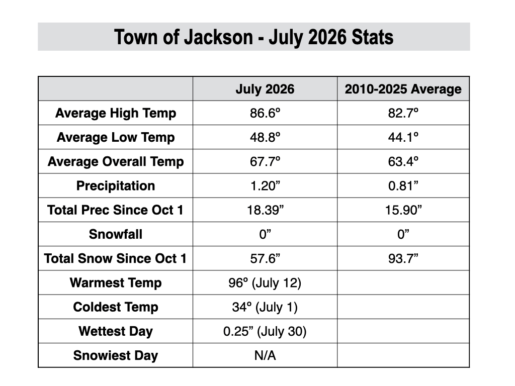
There were 8 days of 90+ degree high temperatures in Jackson during July, and we also had a 16-day stretch from July 14-29 where the low temperature in town dropped below 50ºF only one time. There were also three days during this stretch where the low temperature failed to drop below 60ºF!
For the month as a whole, temperatures ended up 4.3ºF above average in the town of Jackson, based on 2010-2025 data from the JKNW4 weather station.
Longer-range records using the COOP climate station in Jackson are tricky since this station has exhibited a clear cool bias since 2010, but even when factoring in that bias while examining this station’s records, this was the hottest month in Jackson since July 2007.
The Alta weather station in the Tetons also recorded its hottest month since 2007, and the 4th hottest on record since 1909, behind July 2021, 2007, and 2003.
The Moran weather station near Jackson Lake did record its hottest month of all-time in July 2026, with records dating back to 1949.
The map below shows temperature anomalies for the entire U.S. in July. Most of the country had above-average temperatures, except along the West Coast, while the highest anomalies were centered right over Wyoming, Montana, and the Dakotas.

In terms of moisture, all of our rain came from hit-or-miss convective showers and thunderstorms, as is typical at this time of year when frontal precipitation systems are rare.
Pacific disturbances during the first week of July contributed to afternoon thunderstorms and spotty rainfall, while a monsoonal flow during the final two weeks of the month favored more meaningful rain with thunderstorms, including locally heavy rain with stronger storms.
The Teton Range fared quite well during this monsoonal flow, with rain gauges above 8,000 feet at Teton Pass, Jackson Hole Mountain Resort, and Mt. Baird recording anywhere from 3.5 to 5 inches of rain during the month of July.
Rainfall was generally lighter and more variable in the Jackson Hole Valley, ranging from 1-2 inches, which was near to above average in most locations.
The town of Jackson received 1.20 inches of rain in July, which might not sound like a lot. But the average in July is only 0.81 inches (the only month of the year with an average of under 1 inch in town), so this was an above-average rain month in town. Also, measurable rainfall was recorded in town on 15 days in July.
Teton Valley, on the other hand, had fewer measurable rain days in July than the Jackson Hole Valley, but it came in heavier chunks in Teton Valley.
There were two days with locally heavy downpours that produced minor street and field flooding in Teton Valley, including a storm that produced over 2 inches in less than an hour and a half in downtown Driggs.
This rain gauge near downtown Driggs recorded 2.81 inches of rain for the month of July for a whole with measurable rainfall on 9 days, but 2.17 inches fell in one day.
For the region as a whole, most of Western Wyoming and the Idaho border was above-average, but there were some pockets of below-average rainfall over Yellowstone, which is indicative of the hit-or-miss nature of summer rains in the Rockies.

Here is a look at the July weather stats for the town of Jackson.
July continued the theme of what has been a very warm water year (since October 1st) in Jackson and across the Western U.S. as a whole.
The “departure” column in the monthly chart below shows the departure from average temperature each month (factoring in the highs and lows), with red colors and plus signs indicating warmer-than-average months and blue colors and minus signs indicating cooler-than-average months.

Precipitation has been above average in the town of Jackson for the water year, despite the poor winter for snowfall. However, not all locations in the area have seen above-average precipitation, and month-to-month it has been inconsistent, with some very wet months (especially December) and some very dry months relative to average since last fall.

The next chart shows monthly precipitation totals at the upper mountain, mid-mountain, and base area at Jackson Hole Mountain Resort. This gives a good idea of the precipitation distribution by elevation, and how higher elevations typically receive substantially more compared to the valley.
The upper mountain Rendezvous Bowl Plot has now recorded over 50 inches of precipitation during the 2026 water year (since October 1st). Also, one thing that stands out in this chart is that it’s very rare for the mid-upper elevations of the Tetons to receive higher precipitation amounts in July than in January.

Upcoming Weather Pattern
The early August dry spell will continue through the weekend, and temperatures will also heat back up after the early week cool spell, with highs pushing 90ºF in the valley again from Friday to Sunday.
Temperatures will cool off nicely at night, however, given the dry airmass and the fact that the nights are getting longer as we head deeper into August.
Varying levels of wildfire smoke are likely to continue through the weekend as west/northwest winds aloft continue, which is a direct path from where the largest fires are burning in the Pacific Northwest.
Early next week, the Southwest Monsoon will rebuild over the Southern Rockies, and at first, we will likely catch some fringe-level moisture in the Tetons with temperatures staying hot. However, a shift to southwest winds aloft may push the worst of the smoke out of our area, pending any new fire activity to our southwest, of course.
This fringe-level monsoonal pattern durng the first half of next week will favor isolated “dry” thunderstorms during the afternoon hours, meaning that storms will generally produce only light/spotty rain and gusty outflow winds. It’s not a great pattern in terms of fire weather concerns.
The 7-day rainfall projecton from the European Ensemble Model highlights this pattern well, with increasing rainfall over the Four Corners region, but only sparse rainfall reaching the Tetons.
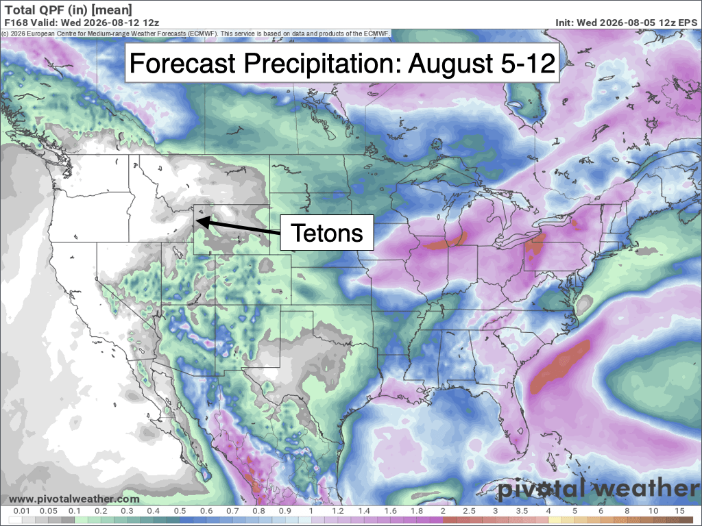
Looking further out, medium to long range models favor a strenghtening monsoon with more abundant moisture potentially pushing into our area late next week and persisting through mid-month.
This would favor a more active thunderstorm pattern with better potential for meaningful rains.
August 2026 Outlook
Climatologically speaking, average rainfall in Jackson Hole increases in August after bottoming out for the year in July, as monsoon moisture intrusions are more common and often more sustained.
From 2010 to 2025, average rainfall in July in Jackson was only 0.81 inches, while average rainfall in August was 1.46 inches.
Last year, August was a drier month with only 0.57 inches recorded in Jackson, but more active Augusts have produced 2-3+ inches in town in the past, including an impressive 3.65 inches in 2022. Year-to-year variations can be large depending on the strength and position of the monsoon.
While organized frontal storm systems are uncommon at this time of year, every so often they can occur late in the month.
During the past 5 years, August was the most active lightning month of the year in the Tetons with an average of 11.2 lightning days, just barely edging out July.
August is also the second warmest month of the year, just slightly cooler than July. However, nights tend to become noticeably cooler as the month progresses due to decreasing daylight hours.
In fact, the average first freeze of the fall season in Jackson is on August 27.
The average high temperature in Jackson in August is 80.9ºF, and the average low temperature is 42.4ºF. Early in the month, average highs are in the low 80s, while late in the month, average highs are in the upper 70s.
In the past 16 years, we have seen temperatures as high as 95ºF (in 2024) and as low as 28ºF (also in 2024).
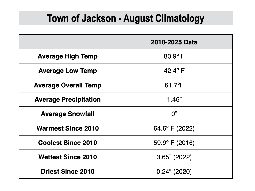
For August of 2026, temperatures are favored to be above-average again, but not to the extent of the “extreme” heat we saw in July.
Rainfall is more of a question mark, as the month is starting out very dry so we will have a lot of catching up to do during the second half of the month.
However, long-range models have been consistent with a returning monsoonal flow during mid to late August, and this is also consistent with El Niño summer analogs.
NOAA’s monthly outlook also favors above-average rainfall in August for Western Wyoming and Eastern Idaho despite the dry start to the month.

As a result, there is a decent chance we head back into an active shower and thunderstorm pattern during the second half of August with the potential for meaningful rainfall.
Alan Smith, Meteorologist











