
JACKSON, Wyo. – Cold and dry conditions have prevailed across Teton County since January 16, but that is about to change late this week. A multi-day storm cycle is set to impact the Tetons from Thursday night through Sunday with the potential for deep snow totals to add up.
Recent Cold and Dry Weather
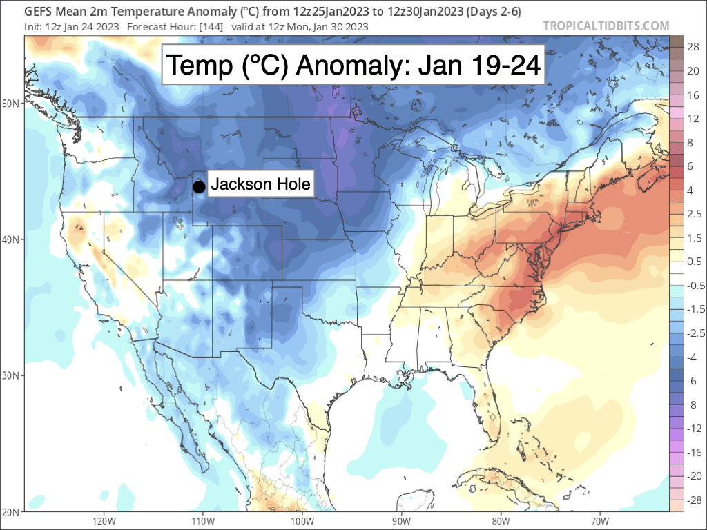
The first half of January featured frequent rounds of light to moderate snow along with mild temperatures. Since January 16, a much colder and drier pattern has taken hold with occasional periods of light snow showers and flurries resulting in minimal accumulations.
From January 16 through January 24, the Tetons only received 2-4 inches of snow while the valley received less than a half-inch.
While not extreme, temperatures have been consistently cold during this dry spell. The temperature dipped below zero in the Town of Jackson on seven consecutive mornings from January 18-24 after not falling below zero a single time between December 25 and January 17.
High temperatures in the Town of Jackson were only in the teens on five consecutive days from January 19-23 after we did not have a single day with a high below 20ºF from December 24 through January 18. Jackson did end its streak of highs in the teens on January 24 when the high rose into the low 20s.
Temperatures for the month of January as a whole are currently right around average in the Town of Jackson, but are running 2.5ºF above average in Moran (at the weather station located near Jackson Lake).
Snowpack Update
The Teton snowpack remains above average, but just barely on the heels of the recent dry spell. As of January 24, snowpack is 104-105% of average in the Upper Snake River Basin, which includes the Teton, Gros Ventre, and Snake River Ranges.

This is down from a week ago when we were sitting at 113% of average, and from two weeks ago when we were 116% of average.
Snowpack is deepest relative to average across southern and central portions of Wyoming and near to below average across Northern Wyoming.

For the Western U.S. as a whole, snowpack remains deepest relative to average across California, Utah, and Arizona, while Western Colorado and Southern Idaho are also doing very well. Snowpack is near to a little below average for areas north of Jackson.

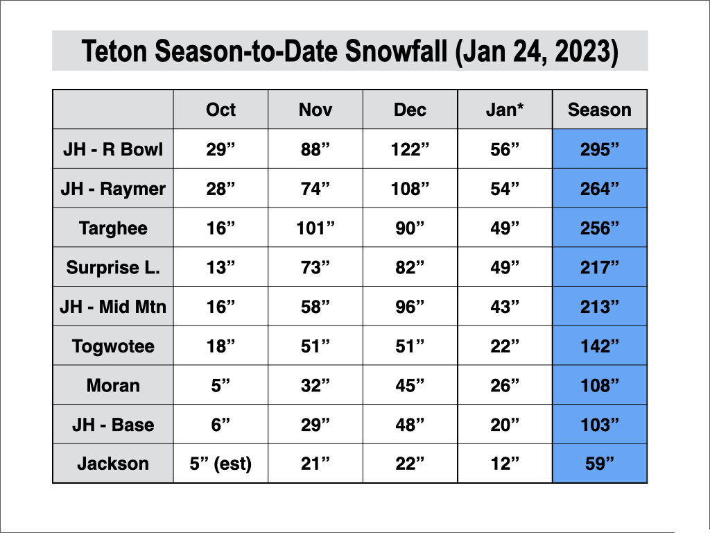
As far as season-to-date snowfall goes, we have seen little change over the past week with the Rendezvous Bowl Plot on Jackson Hole’s Upper Mountain remaining just shy of 300 inches for the time being.
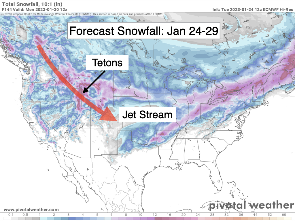
Alas, the dry spell will be coming to an end soon with a more active pattern on the way late this week…
Storm Cycle Expected Thursday Night through Sunday
A trough of low pressure will develop over the Northwest and Northern Rockies this weekend, opening up the door for a series of storms to impact the Tetons.
The first storm will arrive from the northwest late Thursday night and will bring heavy snow to the Tetons on Friday and into Friday night. Additional waves are then expected on both Saturday and Sunday with the potential for deep snow totals to add up over time.
Winds near mountaintop level will primarily be out of the west/northwest from Thursday night through Saturday, which will favor Targhee and the west side of the Tetons along with the upper portions of JHMR for the deepest totals.
The Jackson Hole Valley will see accumulating snow from Thursday night to Saturday, but it will be comparatively lighter due to the shadowing effect from the Tetons.
On Sunday, winds aloft are expected to shift to more of a southwesterly direction, which tends to be more favorable for moderate to heavy snow in the valley and southern and eastern portions of the Teton Range.
Total snowfall from Thursday night through Sunday night should end up ranging from 1-2 feet (12-24 inches) in the Tetons above 8,000 feet and 4-8 inches in the Jackson Hole Valley. Teton Valley, Idaho will likely end up with higher amounts than the Jackson Hole Valley.
Temperatures will also remain on the colder side throughout this storm cycle with highs in the low teens at 9,000 feet and 20s in the valley, which should result in low-density blower powder. Perfect for skiing.
Travel conditions, on the other hand, will be rough throughout this cycle due to consistent snowfall along with moderate winds, which will not have any trouble at all blowing around the dry/powdery snow to result in poor visibility.
Extended Outlook
Confidence is low on when exactly snow will taper off following the weekend cycle. We could dry out as early as Monday or as late as Tuesday. Once the storm cycle ends, arctic air from east of the Divide is likely to spill into Teton County with very cold temperatures in the days to follow.
We may see some light snow chances during the February 1-3 timeframe but overall it looks like a fairly cold and dry pattern. Starting the week of February 4-5 and beyond, there are hints that we could head into a more active pattern with good snow potential.
Alan Smith, Meteorologist


