
JACKSON, Wyo. – Smoke from wildfires in Oregon arrived early on Wednesday. However, this smoke event will be short-lived with clearing expected late in the day on Wednesday.
The big story over the next week will be a wet pattern that will take hold over Labor Day weekend with frequent showers and thunderstorms expected along with the potential for heavy rain.
Wildfire Smoke Update
A fast-moving low pressure system is moving across the Northern Rockies on Wednesday and a cold front moved through Western Wyoming early in the day. Strong westerly winds behind the front have transported smoke into our area from wildfires in Oregon and Northwest California.
Air quality levels briefly deteriorated to the “Unhealthy for Sensitive Groups” category on Wednesday morning with air quality index (AQI) values of over 100. As of early Wednesday afternoon, air quality has improved to “Moderate” (AQI of 50 to 100).
The good news is that the smoke will not hang around for long. The band of smoke will exit the area from west to east by late in the day on Wednesday with improving air quality. It’s possible that some lighter smoke could sneak back in from the south on Thursday evening, but if this happens it will likely be short-lived as well.
Upcoming Weather Pattern
Smoke aside, cooler daytime temperatures and breezy conditions can be expected on Wednesday with highs in the low 70s in the valley. Overnight lows will dip into the low 30s with areas of frost possible.
Thursday is shaping up to be a beautiful day with sunny skies and improved air quality. Highs will reach the mid to upper 70s in the valleys.
The weather pattern will then shift just in time for Labor Day weekend.
A trough of low pressure will deepen along the West Coast late this week and will remain in place through Saturday before eventually moving across the Intermountain West on Sunday and Monday. Increasing southwest winds ahead of the trough will bring monsoonal moisture back into our area.

The first disturbance associated with this pattern change will arrive on Thursday night and Friday morning. Moisture levels will just be starting to increase around this time, but there will be a chance of isolated showers and thunderstorms during the overnight and early morning hours on Friday.
Scattered showers and thunderstorms will then be possible at any time of day on Friday with frequent lightning and locally heavy downpours possible. Highs on Friday will reach the low to mid 70s in the valley.
On Saturday, it’s possible we could see a better weather window during the morning hours though a slight chance of early day showers and thunderstorms couldn’t be ruled out. A better chance of showers and thunderstorms is then expected during the afternoon and evening hours with locally heavy rain possible. Highs will reach the low 70s.
The low pressure system near the West Coast will track inland on Sunday and Monday, and more widespread showers and thunderstorms can be expected across Jackson Hole and Western Wyoming as a result, with the threat existing during both the AM and PM hours. Significant rainfall totals will be possible during this period.
Temperatures will also be cooler on Sunday and Monday with highs in the 60s in the valleys. As the cooler airmass takes hold, snow can also be expected over the higher peaks of the Tetons and surrounding ranges (mainly above 11,000 feet, though this could change between now and then).
Beyond Labor Day Monday, confidence is low on whether or not the unsettled pattern will linger into Tuesday, but for now, a chance of showers can be expected. Temperatures will also remain on the cooler side with highs in the 60s.
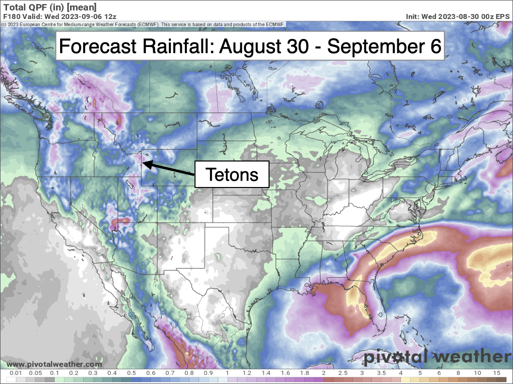
Here is a 7-day rainfall projection, which indicates a wet pattern across Western Wyoming, and for a large portion of the Western U.S.
Extended Outlook
We should finally start to dry out a bit around the middle of next week and into the weekend of September 9-10 as the monsoon weakens significantly. Temperatures are also projected to warm back up with highs well into the 70s in the valley.
Disturbances are still expected to track across the Pacific Northwest and Northern Rockies, and if any disturbance tracks far enough south then a chance of showers couldn’t be ruled out at some point.
Preliminary August Review
August has been a very wet month in the Tetons. The official town weather station near the visitor center has received 3 inches of rain exactly this month, making it the third year in a row with at least 3 inches of rain in August – an impressive streak.
Rainfall was even heavier at my home in Jackson, where I measured 3.52 inches of rain during the month of August.
For perspective, average rainfall in the month of August in Jackson is 1.23 inches.

Also, this has been the wettest June-August period in years in Teton County.
The Town of Jackson weather station near the visitor center has received 6.19 inches of rain during the 3-month period of June through August. This is the highest rainfall total for this period since 1998.
The Moran weather station next to Jackson Lake has received 7.58 inches of total rainfall from June through August 2023. This is the highest rainfall total for this period since 1941!
The Alta weather station has received 7.79 inches of total rainfall from June through August 2023. This is the highest rainfall total for this period since 2009.
No matter which station you look at, it’s clear that this has been a wet summer in the Tetons and Jackson Hole, and in Wyoming as a whole. In fact, the entire state of Wyoming is currently drought-free for only the second time in the past 10 years.
As far as temperatures go, believe it or not, August is going to end up about 1ºF warmer than average in Jackson and right around average in Moran.
The reason has to do with low temperatures, rather than high temperatures.
High temperatures in Jackson are 3.4ºF cooler than normal for the month of August, with an average high of 77.7ºF through August 30. This is not surprising given the number of cool and cloudy days we have had compared to usual.
However, low temperatures in Jackson are running 6.0ºF warmer than normal for the month of August, with an average low of 45.6ºF through August 30. High levels of moisture and more frequent periods of overnight cloud cover have resulted in milder nighttime temperatures than usual.
Alan Smith, Meteorologist


