
JACKSON, Wyo. – August was drier than average with near-average temperatures in the Jackson Hole Valley, while Teton Valley saw higher rainfall totals at the end of the month. September is expected to be a more active month with rain chances increasing this weekend and next week.
Recent Weather and August Recap
Last week, a significant surge of monsoonal moisture reached our area with some parts of Northwest Wyoming and Eastern Idaho receiving substantial rainfall, while other areas saw only modest amounts.
From August 26-29, Grand Targhee received an impressive 2.5 inches of rain while Driggs and Alta recorded between 1.0 and 1.2 inches. Jackson Hole Mountain Resort and Teton Pass also picked up anywhere from 0.8 to 1.3 inches of rain.
Rainfall amounts were lighter in the Jackson Hole Valley with the town of Jackson only receiving 0.39 inches of rain. North of town, rain totals were highly variable, ranging from 0.4 to 1.0 inches.
Also, parts of Star Valley received substantial rainfall with up to 1.7 inches of rain measured in Star Valley Ranch.
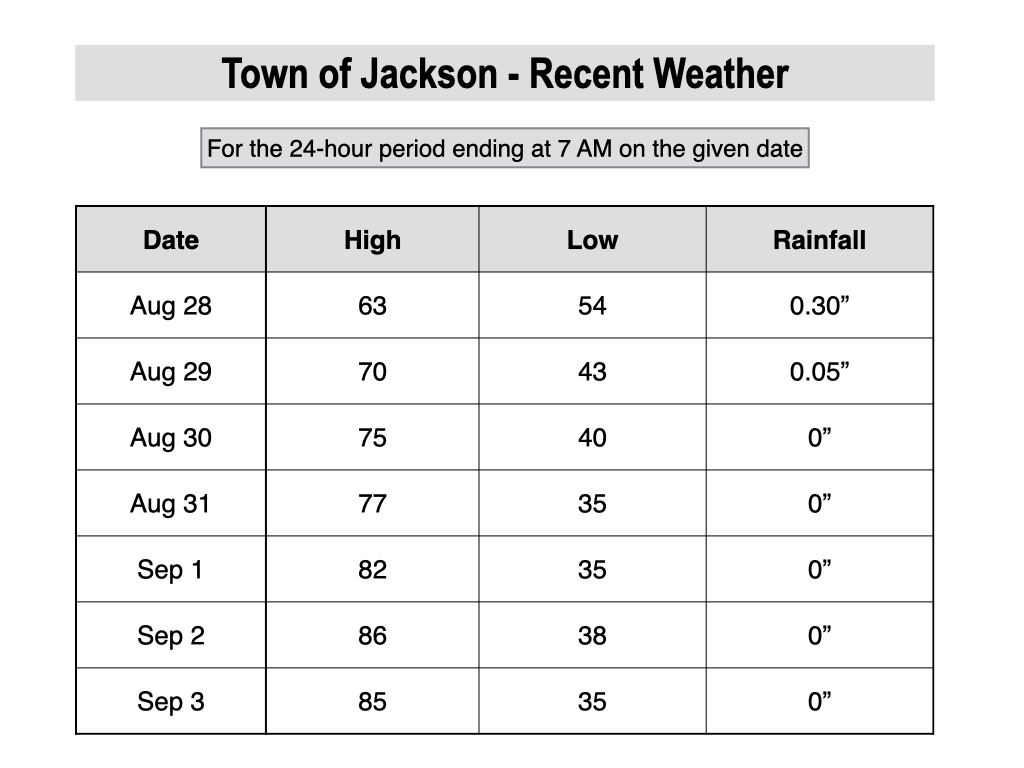
Temperatures were cool and refreshing during this event during the middle of last week, with highs only in the low 60s in the valleys last Wednesday, before gradually warming back up to above-average levels in recent days.
For the month as a whole, rainfall was below-average in the town of Jackson and across most of the Jackson Hole Valley, while Teton Valley saw near-average (or in some cases, above-average) rainfall thanks to the system late in the month.
Prior to the rain at the end of the month, most of August was very dry, and wildfire activity picked up across Western Wyoming in the week prior to the rain event.
Rainfall totals are often hit or miss during the summer months due to the pop-up, scattered nature of showers and thunderstorms, which leads to more random variation compared to the colder months.
For the 3-month period from June through August, which is defined as meteorological summer, rainfall was well below average across Teton County and Western Wyoming, and for much of the Western U.S. as a whole.
However, many areas east of the Continental Divide received above-average rainfall this summer.

In terms of temperature, August was close to average in the town of Jackson (just 0.3 degrees above the 15-year average).
The average high for August 2025 in Jackson was 82.0º and the average low was 41.9º. The warmest temperature of the month was 91º on August 19, and the coldest temperature of the month was 32º on August 10.

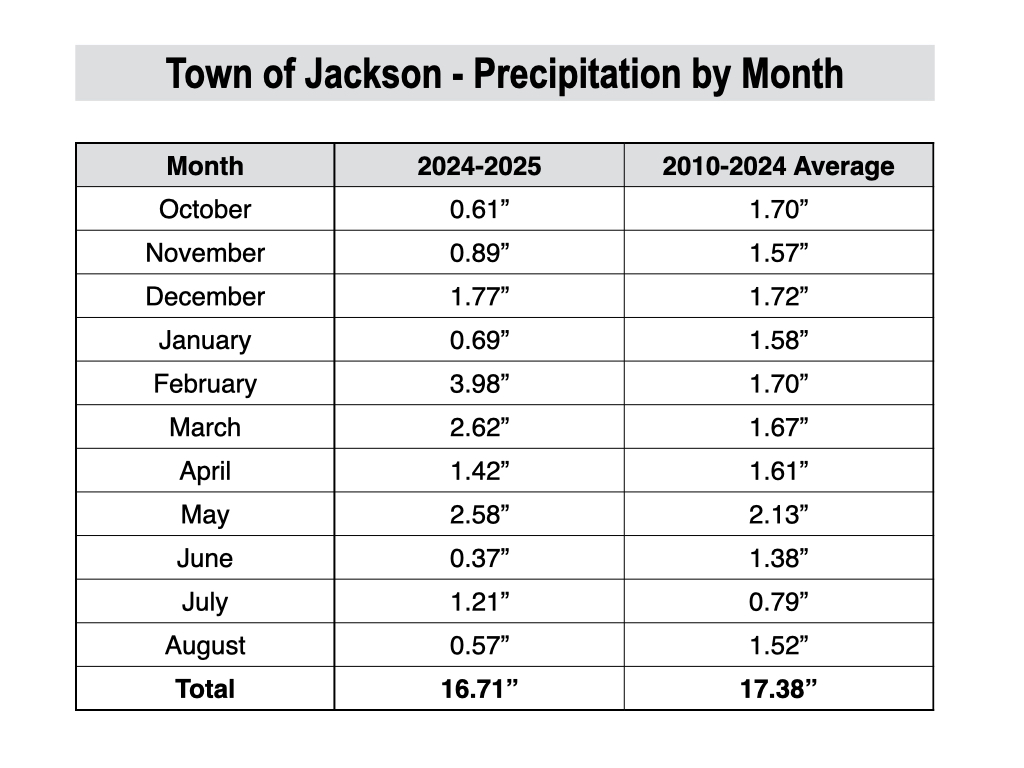
For the water year as a whole (since October 1, 2024), precipitation is slightly below average in the town of Jackson, but across most locations in Western Wyoming and Eastern Idaho, water year precipitation ranges from 10% to 25% below average.
In the town of Jackson, there was a big spike in precipitation between February and May, while the rest of the water year has been much drier.
Current and Upcoming Weather Pattern
Summer conditions will prevail for the next few days, but then we will gradually transition into a wetter and cooler pattern this weekend and next week.
Highs will reach the low 80s on Thursday and upper 70s on Friday with more cloud build-ups and maybe an outside chance of a thunderstorm on Friday afternoon.
Unfortunately, an uptick in wildfire smoke with reduced air quality is also projected on Thursday and Friday, as northwest winds transport smoke from wildfires in the Pacific Northwest toward our area.
Over the weekend, a surge of monsoonal moisture will arrive from the west and southwest, leading to an uptick in shower and thunderstorm chances. This late-season monsoon surge will be enhanced by Tropical Storm Lorena in the Eastern Pacific Ocean, which will hit the Baja Peninsula this week.
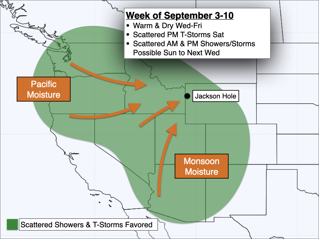
In terms of timing, Saturday will feature scattered afternoon thunderstorms favoring the higher terrain. Weak winds aloft may lead to storms staying anchored over the mountains, with limited storm coverage for the valleys. Storms over the mountains are expected to be disorganized due to the lack of wind shear, but could produce locally heavy rain.
On Sunday, a trough of low pressure will push into the Western U.S., and this could lead to more organized clusters of showers and thunderstorms, with the threat existing during both the morning and the afternoon hours. In other words, there is a higher chance of measurable rain in most areas compared to Saturday.
Next week, a fall-like Pacific low pressure trough is expected to slowly track across the Pacific Northwest and into the Northern Rockies.
This will result in unsettled conditions across our area for much of next week, with near-daily chances of showers and thunderstorms expected.
Temperatures will also trend cooler over time, with highs in the low 70s early next week, but possibly not getting out of the 60s by later next week.
For climbers, snow will likely fall on top of the Grand Teton and the surrounding high peaks (Middle, South, Teewinot, Moran, Buck, etc.) in this pattern.
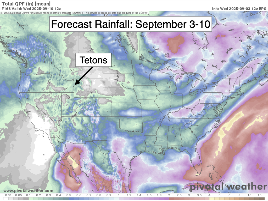
Here is a 7-day precipitation projection from the European Ensemble Model, which represents the average of 50 simulations of this model. Keep in mind, this projection takes us through next Wednesday morning, with more rain possible thereafter.
September Outlook
September is a transition month in the Tetons between summer and autumn, and is arguably the nicest month of the year with comfortable temperatures and more stable weather patterns common.
September is the fourth warmest month of the year in Jackson with an average high of 72.6º and an average low of 34.8º. Freezing overnight temperatures become more common as the month progresses during periods of clear weather.
High temperatures in the 80s are not uncommon early in the month, but become much less likely by mid to late month. Highs of 90 and above are rare in September, but it has happened as recently as 2022.
Average precipitation in September is higher compared to the summer months, and substantial rain events sometimes happen. However, rainfall tends to be more concentrated in a smaller number of days, with extended stretches of dry and sunny conditions also common.
Average precipitation in September in the town of Jackson is 1.71 inches, but actual amounts vary substantially from year to year. For example, in 2018, Jackson received only 0.05 inches of rain in September, but in 2019, Jackson received 3.45 inches of rain in September.
As temperatures trend colder with the changing seasons, the Teton Mountains often receive their first widespread snow event of the season in September, though it usually doesn’t hang around for long except on the shaded aspects of the high peaks.
Accumulating snowfall in the town of Jackson is rare in September, but it happened as recently as 2020 when an inch of snow fell in town.
For September 2025, the pattern is looking more active than what we have seen in recent months, with the potential for wetter weather during the second week of the month as highlighted in the discussion above.
As we head into the second half of September, confidence in the forecast decreases, but there will likely be some warm and dry stretches alternating with cooler and wetter periods.
NOAA’s latest monthly projection has equal chances of above or below normal precipitation in September, while above-normal temperatures are favored (though with plenty of ups and downs expected).
Alan Smith, Meteorologist


