JACKSON, Wyo. — Most of July was a bit cooler than average across Jackson Hole, but August has started on a hotter note as the first “heat wave” of the summer has arrived. Starting on Friday, a strong ridge of high pressure formed over the Northern Rockies, which allowed temperatures to top 90 degrees for the first time this year in the valley on Saturday and Sunday.
The Jackson Hole Airport officially hit 90 on Sunday, while the weather station in the town of Jackson recorded highs of 91 and 92 on Saturday and Sunday, respectively. While average highs in July and August are in the low 80s, we typically see temperatures reach 90 in Jackson Hole a few days each summer.
In terms of moisture, we did pick up some rainfall and thunderstorms became more frequent during the final week of July, and on the first day of August as well. However, July ended up being a very dry month with only 0.52 inches of rain recorded at the Jackson weather station — less than 50% of average.
Fortunately, good rainfall in June followed by cool temperatures in July have prevented conditions from drying out too quickly in the Jackson Hole area. Drought conditions have expanded across Central and Eastern Wyoming, but most of Western Wyoming including Jackson Hole remains drought-free. Fire season has been quiet so far as well.


Weekly Weather Outlook – August 3-9:
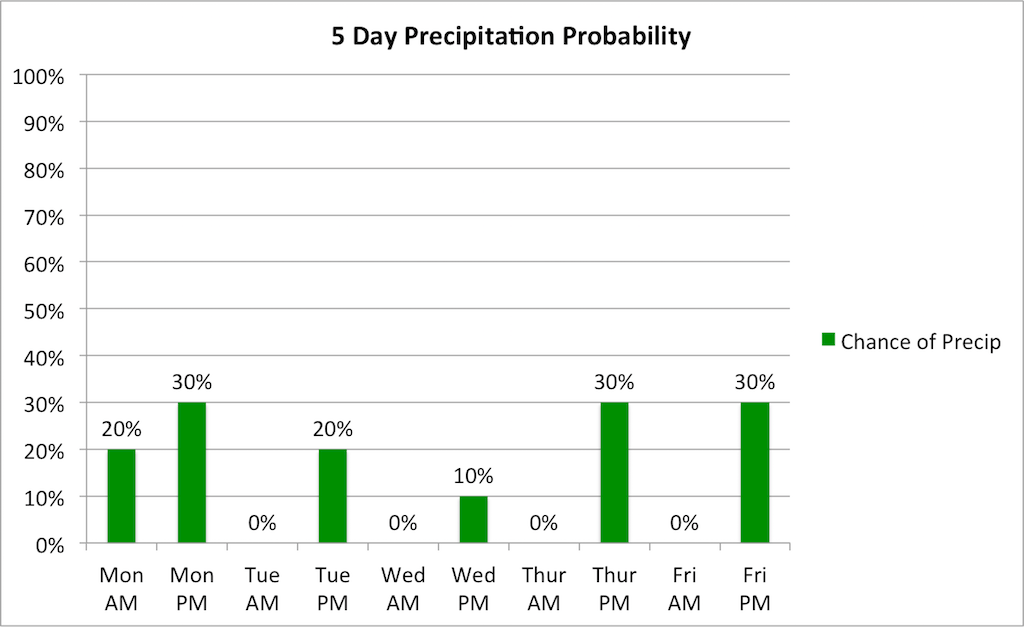
A band of clouds is moving across Jackson Hole on Monday morning, which will delay the day’s warm-up at least for a while. A few sprinkles or very light showers will be possible, mainly over the mountains, but it won’t amount to much.
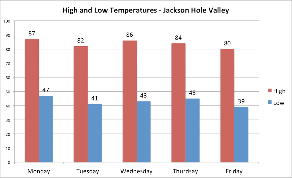
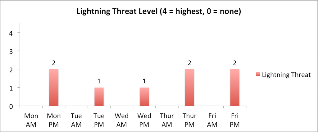
By early Monday afternoon, we should see increasing sunshine but also some isolated thunderstorms developing with storm motions from southwest to northeast. Highs will warm up into the mid to upper 80s, which is not quite as warm as what we saw over the weekend.
A cold front will arrive on Monday evening with isolated thunderstorms possible into the nighttime hours. The more noticeable change will be cooler temperatures on Tuesday with highs in the low 80s and only a minor chance of afternoon thunderstorms.
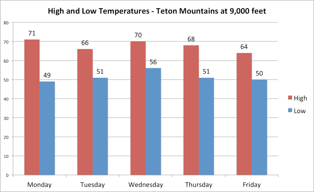
Temperatures will warm back up on Wednesday with mostly dry conditions expected. A trough of low pressure will then approach late in the week with isolated thunderstorms possible on Thursday and Friday afternoons. Another cold front will arrive on Friday, leading to cooler temperatures heading into the weekend.
Temperatures will be quite comfortable this weekend following Friday’s cold front with highs likely topping out near 80 on Saturday and Sunday. Thunderstorm chances look pretty marginal both days, yet some isolated storms can’t be ruled out at this time either, so keep an eye on our daily forecasts throughout the week.
Alan Smith, Meteorologist