
JACKSON, Wyo. – A surge of monsoonal moisture will reach Western Wyoming from the south/southwest late this week, resulting in an uptick in thunderstorms. Thursday and Friday will be the most active days with widespread showers and thunderstorms, some of which will produce heavy rain.
June 2025 Recap
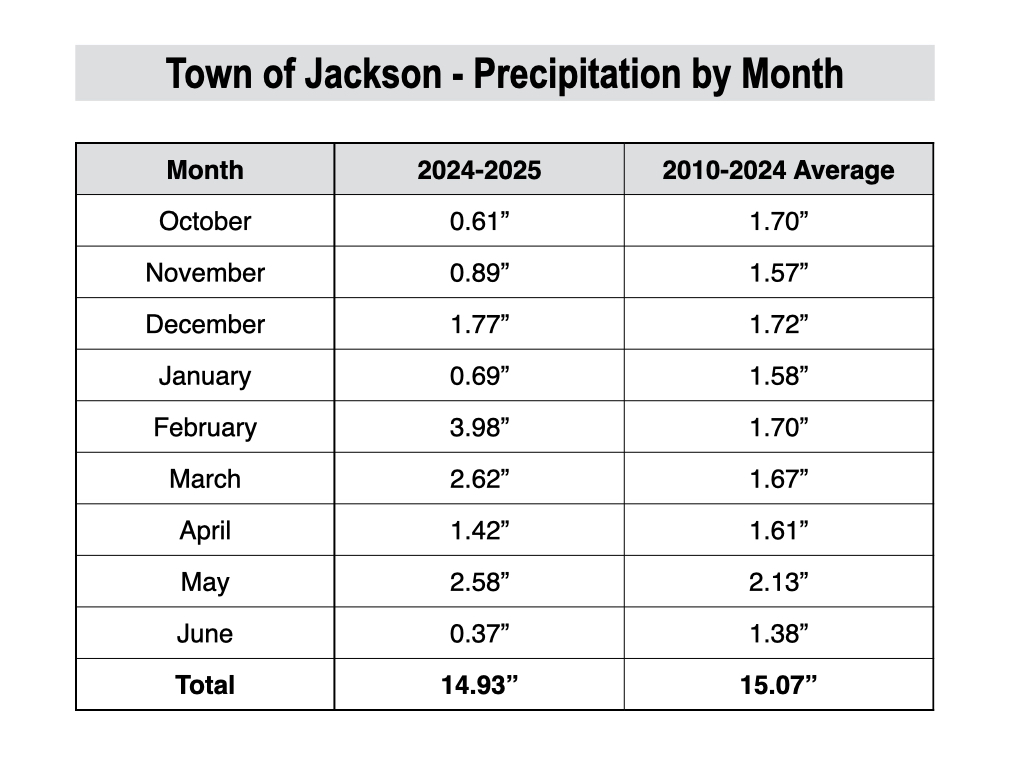
June was much drier than normal and also warmer than normal. The town of Jackson only received 0.37 inches of rainfall in June, which is well below its average of 1.38 inches.
Other areas, especially around Teton Pass and Jackson Hole Mountain Resort, received heavier rainfall in June, given the hit-or-miss nature of thunderstorms that occurred around mid-month, but overall, the entire region ended up well below average for rainfall.
Historically, when rainfall is well below average in June and the previous winter snowpack was not spectacular, it increases our odds of having an active wildfire season.
However, if July and/or August bring above-average rainfall, then that could negate the risk somewhat. 2021 is an example of when June was very dry but mid to late summer was wet, which resulted in a quiet fire season, though smoke was really bad that summer from fires in California, Oregon, and Washington.
Temperatures ended up 1.1ºF above normal during the month of June. We were on track for “well above normal” temperatures, but a cool snap late in the month resulted in just slightly above normal temperatures.
The average high in Jackson during June 2025 was 76.0ºF, and the average low was 39.5ºF. The warmest temperature of the month was 88ºF on June 19, and the coldest temperature of the month was 31ºF on June 23.
Here is the water year summary by month in Jackson since October 1.

Here is a monthly precipitation table for the town of Jackson since October 1.
Early July Outlook, including the Fourth of July
While June was a quiet weather month overall, we are heading into a more active weather pattern during the first few days of July, and could pick up some meaningful rainfall for the first time in several weeks.
The culprit is the onset of the North American Monsoon across the Southwest U.S. The monsoon is a circulation of subtropical moisture that peaks in July and August and typically favors the Four Corners states.
However, we occasionally see surges of moisture reach the Tetons and Western Wyoming, which can lead to more active thunderstorm patterns that can bring beneficial rainfall. Other times, we are just on the fringe of the monsoon, which can lead to “dry” thunderstorms with light rainfall, gusty winds, and increased fire danger.
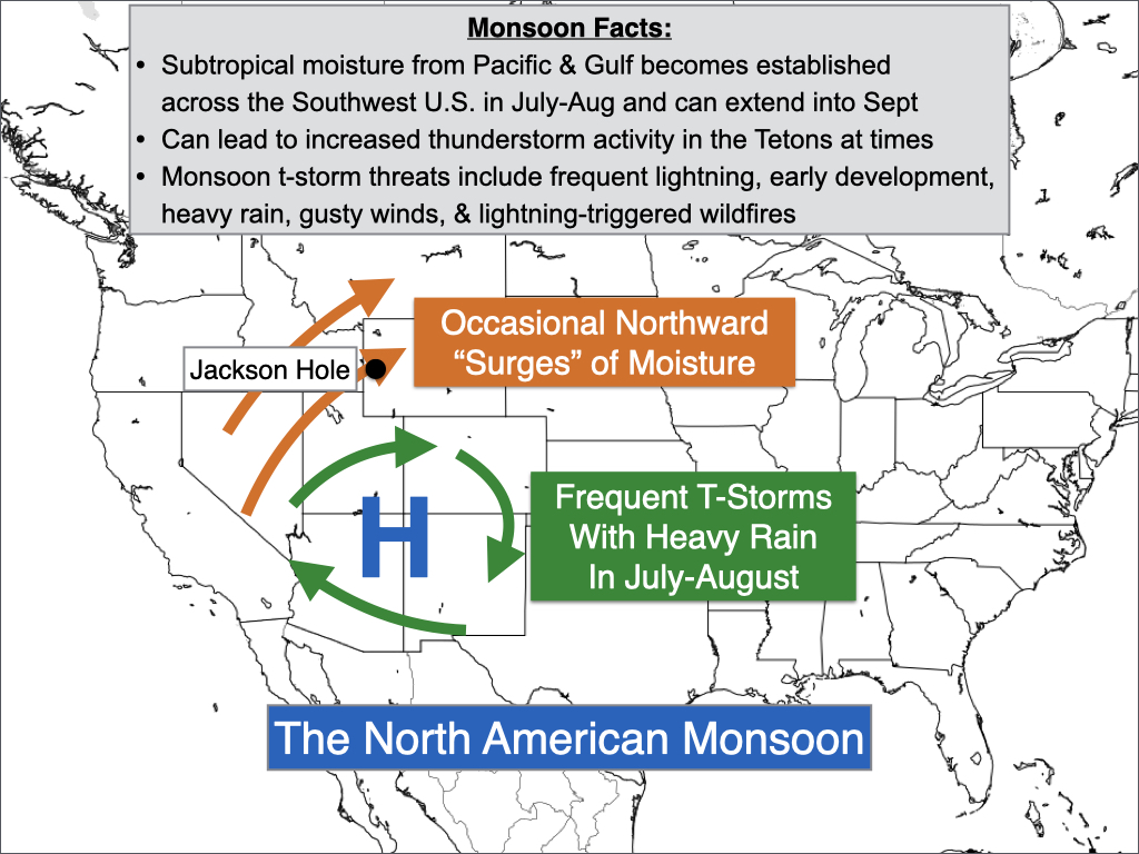
This week, we will see our first monsoonal moisture surge of the season, and this is happening a bit earlier compared to recent years.
Moisture has already started to filter in from the south early this week, which contributed to thunderstorms on Tuesday. However, dry air in the lower levels of the atmosphere resulted in light rain and gusty winds for most locations in Teton County, though some isolated heavier rainfall occurred near Teton Pass.
We are seeing some thunderstorms develop across the area on Wednesday afternoon as well, and most storms will produce light to moderate rain and gusty winds.
On Thursday, a more significant surge of moisture is expected as southwest flow increases ahead of a low pressure trough. This will result in more widespread showers and thunderstorms with heavy rain possible. The best chance of storms will be in the afternoon, but a chance of showers and thunderstorms will exist at all hours of the day.
For the Fourth of July on Friday, a robust disturbance will track across the area, resulting in another active day with multiple rounds of showers and thunderstorms likely. The threat will exist at all hours of the day, with stronger storms capable of producing heavy rain.
The heaviest and most widespread rainfall is projected during the afternoon hours on Friday, but there is at least a chance of showers and storms persisting through the evening hours, so be prepared for the possibility of inclement weather during the fireworks displays.
Rainfall amounts are always highly variable in these summertime thunderstorm patterns, but there is some potential for localized very heavy rainfall in this pattern if training of thunderstorms occurs. In this higher-end but lower probability scenario, isolated flash flooding would be a possibility in areas of steep terrain with poor drainage, and also in recent fire burn scars.
Friday looks like the most inclement day of the holiday weekend, with a more typical afternoon thunderstorm setup expected on Saturday. Lingering moisture and more abundant sunshine could potentially lead to some strong thunderstorms with locally heavy rain possible on Saturday afternoon, though confidence is lower.
On Sunday, we should start to dry out more and also warm back up. Highs will only be in the low to mid 70s from Thursday to Saturday, before warming up into the 80s on Sunday. A warming and drying trend is expected to continue heading into next week.
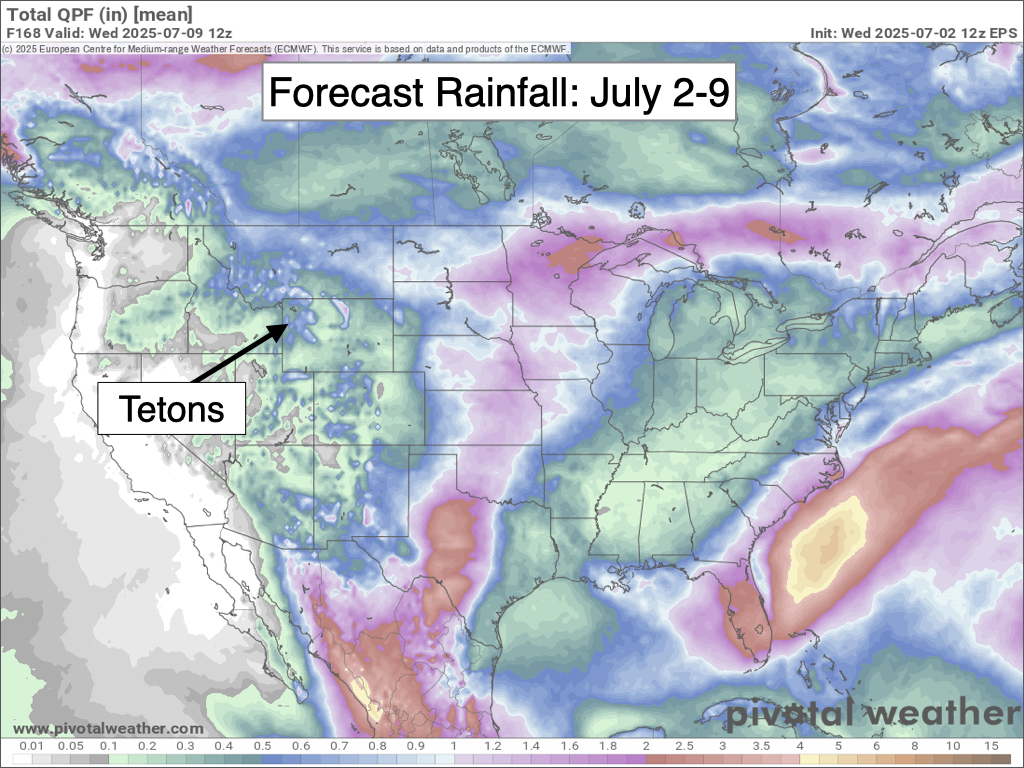
The image below is a 7-day rainfall projection from the European Ensemble Model, which represents the average of 50 simulations of this model.
Looking further out, a return to hotter and drier weather is expected heading into mid-July as high pressure strengthens over the Western U.S. and the monsoon becomes suppressed well to the south near the Mexico border.
Hopefully, we can pick up some beneficial rainfall this week, given this hotter and drier outlook to follow.

Alan Smith, Meteorologist


