
JACKSON, Wyo. – A building ridge of high pressure over the Intermountain West will result in our hottest temperatures of the summer so far this weekend. Monsoonal moisture rotating around the high pressure center will sneak into our area at times, resulting in isolated thunderstorm chances on Thursday and again early next week.
Recent Weather Summary
The past 10 days have been completely dry across Teton County with sunny skies and highs in the 80s across the valleys. The Town of Jackson has only received 0.10 inches of rain so far in the month of July, and it’s unlikely we will reach our average July rainfall value of 1.12 inches.
During the first 10 days of the month, rainfall totals were higher north of Jackson with 0.42 inches recorded at Moran/Jackson Lake and a half-inch to one inch of rain at most weather stations in Yellowstone. Wilson and Victor also received locally heavy rainfall earlier this month.
But the drying trend has been substantial across all areas during the past 10 days, and seasonally hot temperatures along with gusty winds have accelerated the drying process.
Temperatures in Jackson are running slightly above average so far this month, while further north, temperatures have been right around average in Moran/Jackson Lake and slightly below average in Yellowstone.
While it has felt hot outside recently, this month has not been as hot so far compared to the previous two Julys.
Taking a look at the current pattern, warm, sunny and breezy conditions are prevailing once again on Wednesday with highs expected to top out in the mid 80s in the valley.
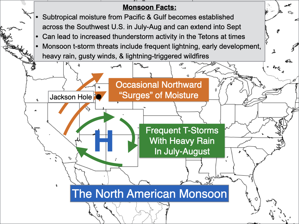
The North American Monsoon
On Thursday, a disturbance moving across the Central Rockies will usher in some moisture from the south, resulting in a chance of thunderstorms. This moisture will be associated with the North American Monsoon, which is a circulation that develops seasonally across the Southwest U.S.
The monsoon typically results in frequent thunderstorms and locally heavy rain in July and August (and occasionally September) across the Southwest U.S. as well as the Colorado Rockies, while further north we can occasionally see monsoon moisture intrusions in the Tetons/Yellowstone as well.
In Western Wyoming, we are most likely to receive moisture and thunderstorm activity associated with the monsoon from about mid-July through early September, though this varies from year to year.
The monsoon originates from subtropical moisture in the South Pacific Ocean and Gulf of Mexico. As a high pressure center builds over Mexico early each summer, winds blowing around the high will transport moisture into the Mexican highlands where showers and thunderstorms become common, usually starting in June.
By early July most years, this monsoon circulation extends northward into the Western U.S. and typically hangs around through late summer and sometimes early fall.
The previous two summers, we received significant and consistent monsoon moisture surges during the month of August with heavy rainfall. During both August 2021 and August 2022, Jackson received well over three inches of rainfall.
The odds are against something like that happening again this year – both from a climatological standpoint (August rainfall was well above average in both 2021 and 2022) and because this year’s monsoon doesn’t look as strong compared to the last two years.
However, it’s still possible we could see some impacts later this summer. The monsoon is becoming established later than usual this year and is just now getting going in the second half of July.
Once the monsoon becomes more well-established, we could potentially see more significant moisture intrusions heading into August depending on the position of high and low pressure systems and resulting winds which could either transport moisture northward our keep moisture more suppressed to the south.
During weaker monsoon moisture surges, or in instances when we are just on the fringe of the moisture plume (such as this upcoming week), Teton County may only see “dry” thunderstorms with light and spotty rainfall, though cloud-to-ground lightning and gusty thunderstorm winds still pose a threat to outdoor recreation in these setups. This type of setup can also result in elevated fire risk if vegetation fuels are dry enough.
During stronger monsoon moisture surges, we can see more widespread thunderstorms capable of locally heavy rainfall along with more intense lightning activity. Thunderstorms can also develop earlier in the day (often by noon) during stronger monsoon surges, posing a higher threat to hikers and climbers from a lightning safety standpoint.
The impacts of the monsoon across Western Wyoming can vary significantly from year to year. The past two summers featured an active monsoon in our area, especially in August. However, previous summers were much less active.
Upcoming Weather Pattern
On Thursday, our first “surge” of monsoonal moisture of the season will arrive, resulting in a better chance of thunderstorms. However, this will qualify as a weak monsoon moisture surge, resulting in generally isolated thunderstorms.
Dry air will still be in place across the lower levels of the atmosphere despite the overall uptick in moisture. As a result, thunderstorms will produce only light and spotty rain, with gusty winds and cloud-to-ground lightning being the primary threats.
On Friday and Saturday, a strong ridge of high pressure will rebuild over the Central Rockies and we will also dry out significantly. The result will be a hot and sunny pattern with highs reaching the upper 80s on Friday and around 90 on Saturday.

The hot weather will stick around through early next week, but another weak surge of monsoonal moisture is expected to work its way northward into Western Wyoming, resulting in at least a chance of isolated afternoon thunderstorms during roughly the Sunday to Tuesday timeframe.
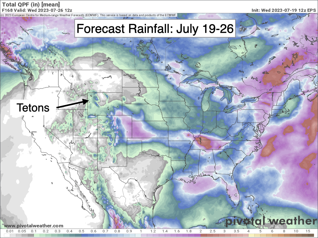
Rainfall during this pattern still looks light and spotty overall as we will be right on the northern fringe of the monsoon. Thunderstorm/rainfall coverage does look a bit higher near and east of the Continental Divide across the Winds, Absarokas, Beartooths, and Bighorns.
Further south, the Colorado Rockies look most favored to see more numerous thunderstorms and heavier rainfall.
Despite the uptick in moisture and thunderstorm chances, it will not be enough to cool us off significantly. Temperatures will remain hot through early next week with highs projected to reach the low 90s on Sunday and upper 80s on Monday and Tuesday.
Extended Outlook
It looks like we will remain on the northern fringe of the monsoon through the end of July with occasional thunderstorm chances entering the picture.
It remains to be seen whether or not we see any more significant surges of monsoon moisture toward the end of the month and into early August, or if isolated “dry” thunderstorms will be the dominant pattern.
Temperatures are also expected to remain hotter than average through the end of July. Occasional upticks in cloud cover could potentially help to curb afternoon temperatures at times but could also lead to warmer overnight lows.


