


JACKSON, Wyo. – The weather pattern will turn more active late this week with daily rounds of showers and thunderstorms from Thursday to Saturday. Temperatures will also trend cooler, with snow levels lowering to 10,000 to 11,000 feet on Saturday.
Recent Weather Conditions
The past week, and really for much of the past two weeks, beautiful early fall conditions have prevailed with comfortable temperatures and only occasional showers. The first half of September has been drier than average across the area, but this is on the heels of a wetter than average July and August.
Temperatures have been running close to average during the first half of the month, but we did see a hard freeze on Tuesday morning in the wake of a strong cold front, with the low temperature dipping to 24ºF in Jackson.
Highs have generally been getting into the 70s lately, but as the cold front moved through on Monday, we only saw a high of 61ºF.
Here is the 7-day weather summary for the town of Jackson:
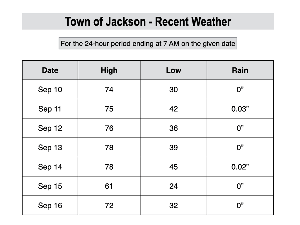
For perspective, the average high and low temperatures in Jackson on September 16 are 73º and 35º.
Upcoming Weather Pattern
The stable fall weather pattern we have experienced recently will give way to a more unsettled weather pattern during the second half of the week.
A slow-moving low pressure area will approach from the west late this week. This will not be a classic fall low pressure system like we can sometimes see at this time of year.
Rather, this system will have more of a late summer “showery” feel as it will pull moisture from the Southwest Monsoon into our area, which is not typical for this late in the season.
However, we will still see a cooling trend in this pattern as a cloud cover increases and a cold front arrives later on Friday.
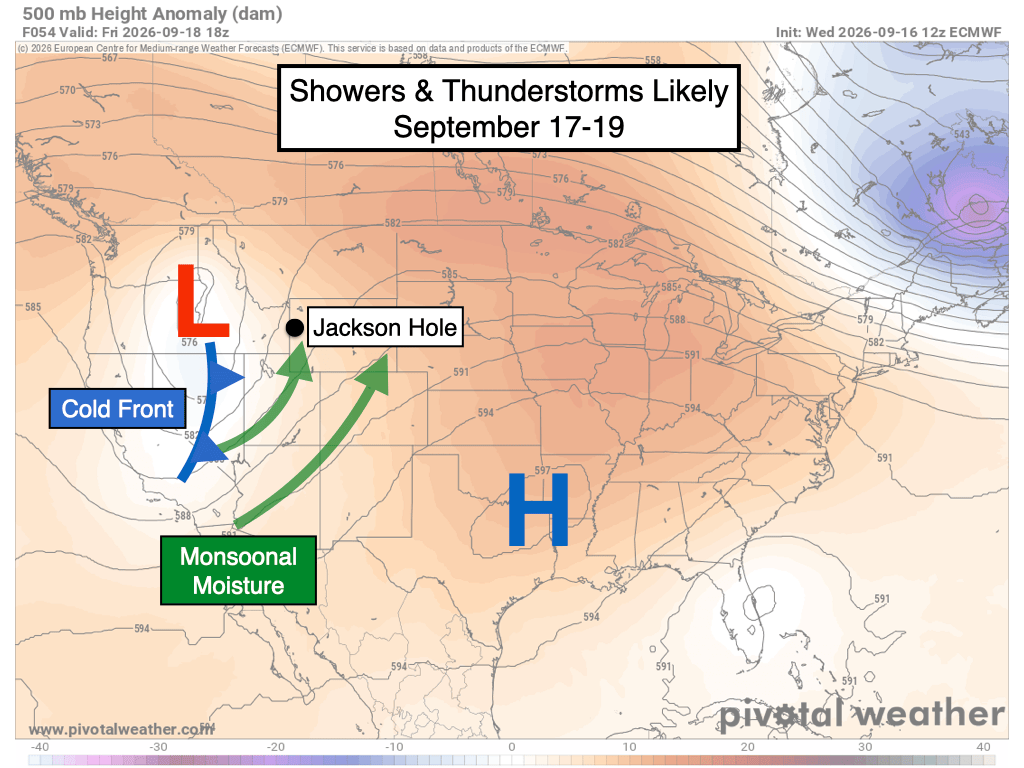
Showers and thunderstorms will be possible at all hours of the day on Thursday, Friday, and Saturday, but will be intermittent in nature with dry spells in between.
The latest model guidance is projecting roughly a half-inch to an inch of rainfall across the area through Saturday night, but variations outside of this range are possible given the convective (hit-or-miss) nature of showers and thunderstorms.
Lightning is possible each day from Thursday to Sunday, but the highest threat of lightning is expected on Friday PM as instability increases ahead of an approaching cold front. Thunderstorms also have the potential to produce locally heavy rain in this pattern.
Even though we’re heading into the second half of September when we often start thinking about the first snows in the mountains, the snow levels (the rain/snow line) will start out high in this pattern and will only gradually come down as cooler air arrives later Friday and into Saturday.
Initially on Thursday, snow levels will range from 12,500 to 13,500 feet (near the summits of the highest peaks in the Tetons), before dipping to 10,000 to 11,000 feet on Saturday.
High temperatures in the valley will be in the upper 60s on Thursday and Friday, and upper 50s to low 60s on Saturday.
Conditions should start to dry out on Sunday, but we could see some lingering cloud cover and a few lingering showers also couldn’t be ruled out depending on how quickly (or slowly) the system exits.
A warming and drying trend is then expected during the early part of next week with highs in the 70s under more abundant sunshine.
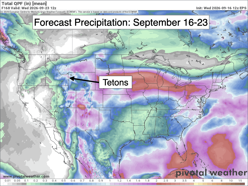
Looking further out, confidence is relatively low beyond next Wednesday, but there are some hints of unsettled weather returning at some point during the final week of September.
NOAA’s 8-14 Day Outlook has a moderate signal for above-average temperatures and a slight signal for above-average precipitation across our area from September 24-30.

Alan Smith, Meteorologist











