
JACKSON, Wyo. – The Rendezvous Bowl Plot at Jackson Hole Mountain Resort has exceeded 500 inches of snow for just the fifth time in its history prior to April 1. Despite the recent thaw event down low, the Town of Jackson has also topped 100 inches of snow for the season.
An impressive winter for the Tetons
We’ve hit two major milestones over the past week as the Rendezvous Bowl Plot at Jackson Hole Mountain Resort has hit 500 inches of snow for the season and the Town of Jackson has hit 100 inches of snow (note: estimates were used for town in late October due to missing data).
Check out the season-to-date totals from locations throughout Teton County:

The Rendezvous Bowl Plot averages 392 inches of snow through April 1, so we are well above average this season. Also, this is only the fifth time since 1974-1975 that this location has reached 500 inches prior to April 1.

The Town of Jackson averages 75 inches of snow per season, so anytime we hit 100 inches in town is impressive. The deepest season in town in recent memory occurred in 2018-2019 when 131 inches of snow was recorded. So while this winter is impressive, it is highly unlikely we will match the 2018-2019 season in town.
Consistent snowfall and consistent colder than average temperatures have also contributed to a deep snowpack in town. In fact, the snowpack in town this winter was the second deepest in the last 10 years, behind only 2019.
We reached a maximum snow depth of 34 inches on March 10 and this will end up being the peak for the season as snowpack has since decreased to 25 inches due to rain and consistent above-freezing temperatures this week.
Check out how this year’s maximum snow depth in town has compared to the past 10 years. Given the late peak in snow depth (on average, the peak occurs in February) this year along with cold late season temperatures forecasted, it will likely be well into April before snow melts out in town this year.

Mountain snowpack is currently 112% of average across the Upper Snake River Basin. Within this basin, snowpack is deepest relative to average in the Teton Range, but is actually near to slightly below average at Togwotee Pass and across the Gros Ventre Range.

The Phillips Bench Snotel in the Southern Teton Range, which has data going back to 1980, is currently 118% of average.

Snowpack for the state of Wyoming as a whole is very healthy for this time of year.

Rain and wet snow early this week to give way to cool and dry conditions late in the week
March as a whole has been much colder than average so far. However, we have seen a noticeable transition to more spring-like conditions in the valley this week due to a warm multi-day storm system that has produced rain across the lower elevations.
The deep snowpack in town prior to a prolonged period of above-freezing temperatures with off-and-on rain showers, even during the overnight hours, has resulted in a big mess in town with melting snow, heavy slush and lots of standing water in low-lying areas.
Colder temperatures will return after this storm, but given that we are halfway through March, it’s safe to say that the melt season is now underway in the valley, even if it ends up happening more gradually than usual moving forward.
A cold front has moved through the area on Wednesday and the effects will be most noticeable once skies clear out on Wednesday night with lows falling into the single digits. Be careful for dangerous icy conditions on the roads and sidewalks on Thursday morning, not to mention the lower elevation ski slopes.
From Thursday through Sunday, we will see our first multi-day dry spell in quite some time. Scattered cloud cover on Thursday will give way to mostly sunny skies from Friday through the weekend as a weak ridge of high pressure builds over the Northern Rockies.
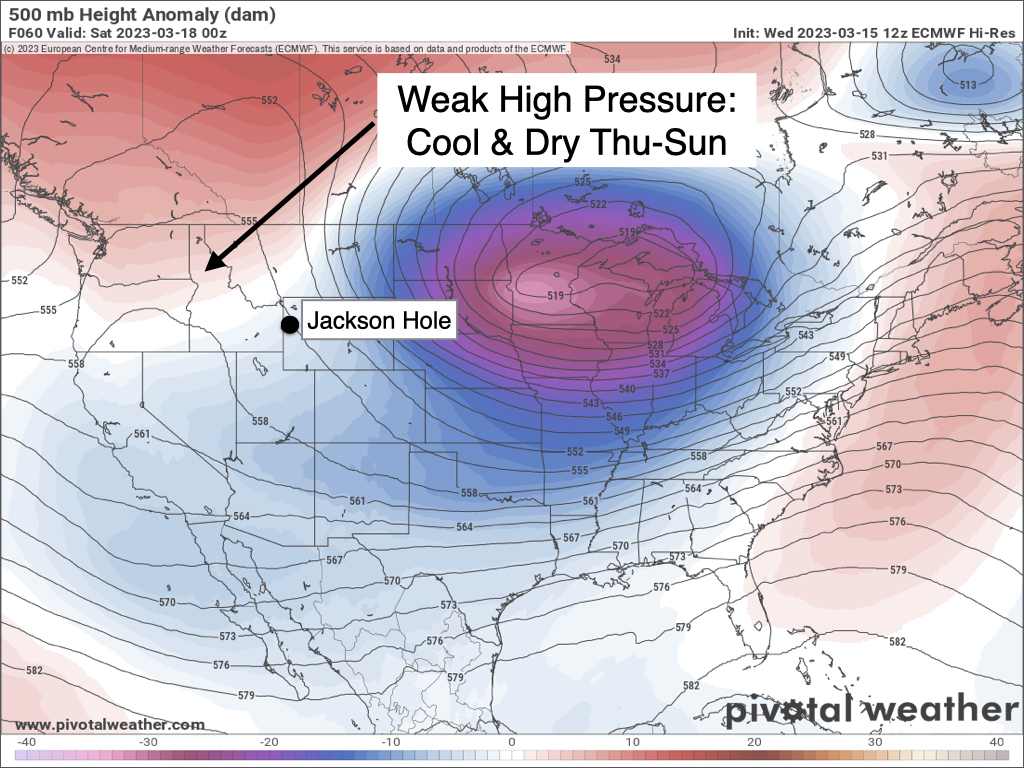
Despite the dry and sunny spell, north/northeast winds will reinforce a cold airmass with temperatures running below average for this time of year. High temperatures in the valley will only reach the low to mid 30s each day with lows falling below zero. The long-term average high in mid-March in Jackson is in the mid 40s for perspective.
Unsettled weather returns next week
The jet stream will nose its way back into California next week as storms return to the Western U.S. The dominant storm track will set up to our south, favoring the Sierra Nevada Range in California (once again) as well as Utah and Colorado.
The Tetons will be on the northern fringe of the storm track, but we will likely see snow make it this far north during the Monday to Wednesday timeframe of next week.

At the moment, temperatures are projected to be cold enough that valley precipitation is more likely to be in the form of snow rather than rain. However, we are getting late enough in the year that it becomes more difficult for snow to accumulate in the valley.
Extended Outlook
It looks like an active pattern is going to continue right through the end of March with frequent snow chances expected along with consistent below average temperatures. Winter will live on across the higher elevations, while the lower elevations will see a gradual transition to more spring-like conditions.
Alan Smith, Meteorologist


