
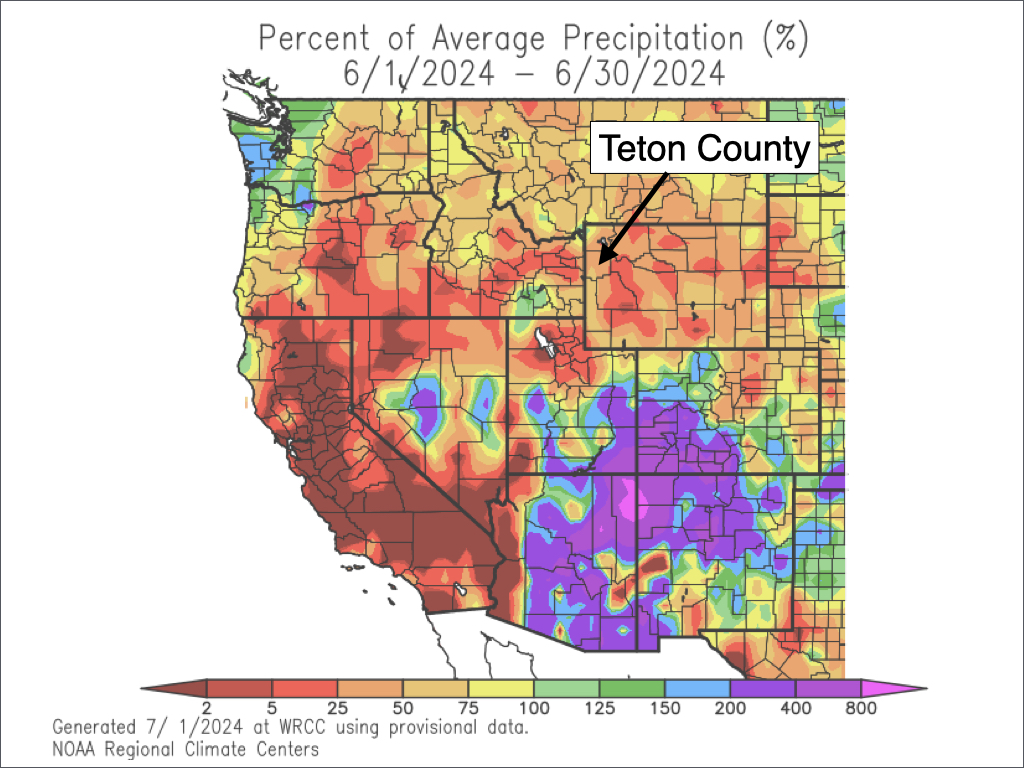
JACKSON, Wyo. – June 2024 was warmer and drier than average across Teton County with rainfall of only 30-40% of average. The first week of July will be cooler and breezy, with the potential for a stretch of hot weather during the second week of July.
June 2024 Recap
Following a cold and active May, we saw an abrupt transition to warm and dry conditions during the month of June – even more so than usual.
The town of Jackson had an average high of 75.4ºF in June 2024, which was nearly 18 degrees warmer than May when the average high for the month was only 57.7ºF.
The average high and low for the month were 75.4ºF and 43.0ºF respectively. When averaging the high and low temperatures together, temperatures ended up 3.0ºF above normal in Jackson this month and 3.8ºF above normal at the Moran/Jackson Lake weather station.

The high temperature exceeded 80ºF on 12 days in June in the town of Jackson. The highest temperature of the month was 87ºF, which occurred on both June 23 and June 25.
While it was a warm month overall, there was a brief but intense cold snap during the middle of the month that resulted in a daily record low of 24ºF on June 19. For the month as a whole, there were three mornings with sub-freezing temperatures, but there were also seven mornings in which the low did not drop below 50ºF.
The town of Jackson only received 0.53 inches of rain during the month of June, which is well below the June average of 1.59 inches. This was a stark contrast to June 2023 when 2.64 inches of rain fell in town.
The only significant rain event of the month occurred on June 3-4 when Jackson picked up 0.28 to 0.40 inches of rain and the Raymer Plot at just over 9,000 feet received 1.05 inches of rain.
While June was warm and dry overall, it was not quite as warm or as dry as June of 2021. Fire concerns were high heading into that summer, but an uptick in moisture mid to late summer saved us from having a bad fire season that year (though the smoke was terrible that summer due to large fires in California).
Above-average temperatures and below-average rainfall in June are not an ideal combo when it comes to fire danger, as this can result in fuels drying out more quickly than usual. We have already seen fire danger rise to “Moderate” recently.
What happens from here on out in terms of fire danger and fire activity will largely depend on temperature and rainfall relative to average for the rest of the summer.
Winds were also stronger than usual in June as frequent low pressure systems moved across the Northwest and Far Northern Rockies, with the jet stream located just north of our area. Wind is an X-factor when it comes to fire danger, so let’s hope we see less of that in July and August.
For the water year (which runs from October 1 to September 30), the town of Jackson has received 14.61 inches of precipitation, which is right around average for the date. Average annual precipitation is 18.66 inches (based on 15-year data), so we’ll see if we can hit that mark with three months left to go in the water year.
Current and Upcoming Weather Pattern
The first day of July is starting off a bit more active with a trough of low pressure moving across the Northern Rockies. A cold front also arrived early in the morning, and we are enjoying a refreshing day with highs in the low 70s along with brisk winds.
Thunderstorms have also been firing up over Yellowstone and the Central/Northern Tetons since about midday, and storms will remain possible through the evening. The activity has been gradually extending southward over time, so the lower valley may eventually see a thunderstorm.
Storms are moving from west to east at relatively fast speeds but will have the potential to produce brief downpours, small hail, and frequent cloud-to-ground lightning.
From Tuesday to Friday, we will remain in a relatively cool northwest flow pattern with high pressure over the West Coast and a trough of low pressure over the northern plains.
This will result in dry and breezy conditions over the Tetons, while Yellowstone, the Wind River Range, and areas east of the Continental Divide will hang onto afternoon thunderstorm chances.

Highs will only be in the low to mid 70s through the Fourth of July, which is below average for early July (average highs in early July are in the upper 70s to low 80s).
By the weekend, high pressure will begin to work its way eastward from the West Coast into the Intermountain West. Temperatures will begin to heat up as a result with highs in the 80s on Saturday and Sunday.
Next week (July 8th and beyond), high pressure will continue to build over the Rockies, and the potential exists for a stretch of hot weather by our standards, with 90+ degrees not out of the question. Of course, this is still a week or more away, so things can still change between now and then.
July Outlook
July is the hottest and driest month of the year in Jackson Hole. High temperatures in the 80s are typical and we usually hit 90º a couple of times each July as well. Fortunately, temperatures typically cool off into the 40s for overnight lows which offers a natural form of air conditioning.
In the town of Jackson, the average high in July is 82ºF and the average low is 44ºF based on the previous 15 years.
July is the one month of the year when freezing temperatures are rare in the Jackson Hole Valley, but it’s not unheard of either. The last time we saw a low temperature dip to 32ºF in Jackson during July was in 2015.
The town of Jackson only averages 0.82 inches of rain during July. However, thunderstorms are also common with an average of 10 thunderstorm days. Some of the thunderstorms that develop at this time of year produce very little rainfall.
Typically, late July is more active than early July in terms of thunderstorm chances and rainfall potential. This has to do with the North American Monsoon, which is a circulation of subtropical moisture that develops over the Southwest every summer.
The monsoon typically builds over the course of the month during July, with northward moisture surges more likely to reach the Tetons by late in the month.
Monsoon moisture can sometimes be fleeting, but in other instances, it can result in consistent thunderstorm activity with “stronger” moisture surges leading to better chances of measurable rainfall and locally heavy downpours.
For July 2024, conditions look to stay dry early in the month due to high pressure just to our west acting as a barrier. Heading into mid-July, we may see high pressure shift far enough east to potentially open up the door for some moisture to arrive from the south – which could lead to an increase in thunderstorm chances.
In terms of temperature, long-range models are in strong agreement of above-average temperatures this month. In other words, beyond the cooler first few days of the month, this is shaping up to be a hot month by local standards.
Thanks for reading and Happy Fourth of July!
Alan Smith, Meteorologist


