JACKSON, Wyo. – October was wetter and warmer than average in the Tetons, while snowfall was below average. November is starting out mild and dry with limited snow potential through the first half of the month.
Recent Weather Pattern
The most notable weather over the past week involved a slow-moving low-pressure system tracking across the Southern Rockies that transported subtropical moisture into our area over the weekend.
Similar to many other events this fall, this system brought good moisture to the area but milder temperatures led to high snow levels above 9,000 feet for much of the event.
Areas below 9,000 feet received 0.5 to 1.5 inches of rain from Friday night through Monday morning, while the higher elevations of the Tetons (above 8,500 feet) picked up 2 to 6 inches of snowfall, mainly on Sunday night when temperatures and snow levels dropped.
Snow coverage heading into early November is primarily limited to areas above 9,000 feet, while snow depth as measured by snow study plots in the 9,000 to 10,000 foot range in the Tetons is running below average for this time of year (though it’s still very early).
High temperatures have generally been in the 40s to 50s in the valley over the past week, with overnight lows in the 20s to 30s. Cloud cover early this week resulted in several days in a row without a valley freeze, and even on Wednesday morning, we only had a light freeze.
Here is the 7-day weather summary for the town of Jackson:
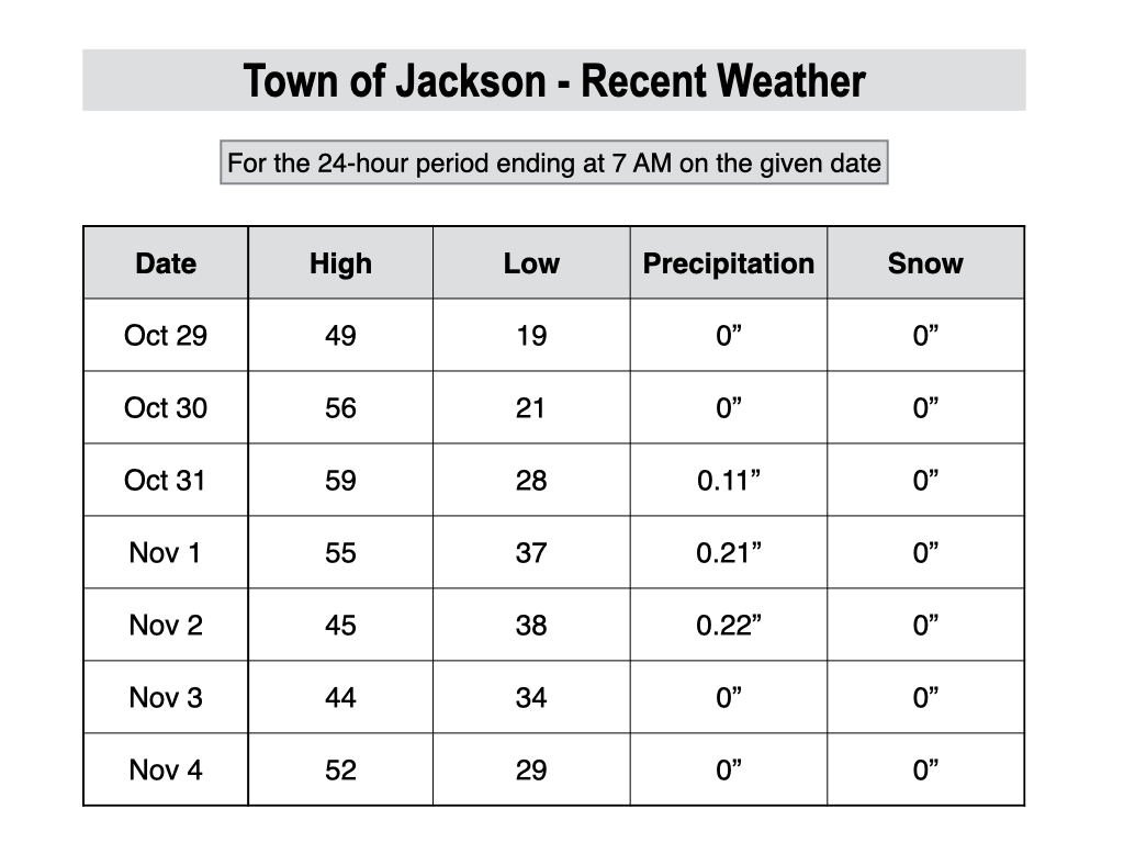
For perspective, the average high and low temperatures in Jackson on November 4 are 47º and 21º.
October 2026 Review
October weather ranged from unseasonably warm and dry early in the month, to very wet at times mid to late month as storm systems loaded with subtropical moisture impacted our area.
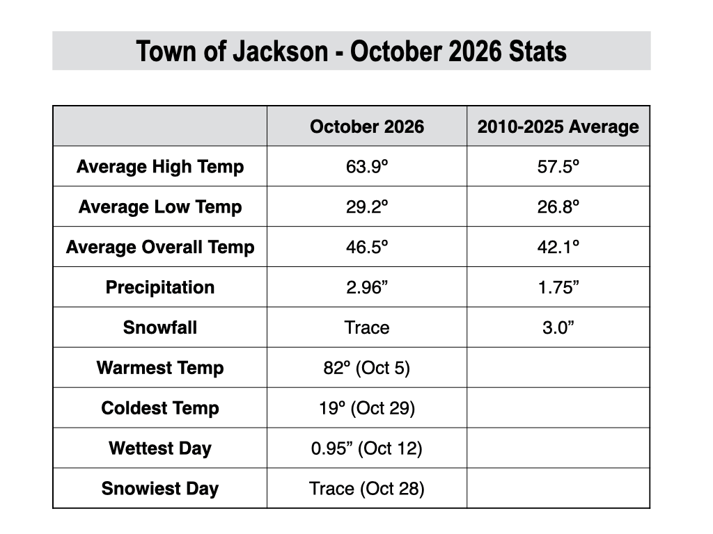
For the month as a whole, temperatures were above average, and precipitation was also above average.
From October 1-9, extended summer conditions were present with a ridge of high pressure in place over the Western U.S., which resulted in dry and sunny conditions along with well above average temperatures.
In fact, several area weather stations reached record high temperature levels during the first week of the month.
The town of Jackson (JKNW4 weather station), had highs of 80º and 82º on October 4 and 5. These were the first 80º days in the month of October since 2010.
A big change to the weather pattern occurred from October 10 to 14 as a low pressure system containing moisture from the remnants of Tropical Storm Rachel impacted our area.
This storm system brought substantial rainfall to the region, with 4-day totals of 1.9 inches in the town of Jackson. In the Tetons, rain totals ranged from 2 to 3.5 inches, while areas above 8,000 feet picked up 1-3 inches of snow as colder air arrived at the end of the event.
A dry pattern returned from October 15-21, though we did see some light rain showers arrive late in this period. The next system brought more rain to the valley and a mix of rain and snow to the mountains from October 22-24 with total precipitation ranging from 0.75 to 1.25 inches
A third system during the final week of the month brought light rain to the lower elevations and light snow to the higher elevations on October 27-28.
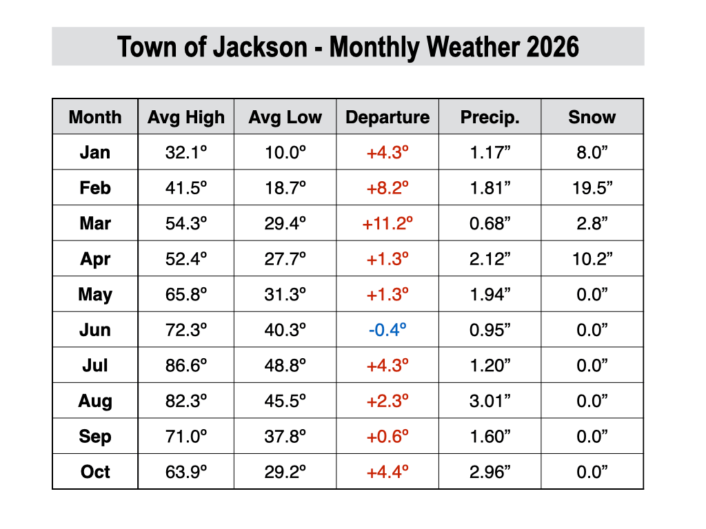
For the month as a whole, temperatures in Jackson were 4.4 degrees above normal, making this the warmest October since 2015. Interestingly enough, that was the most recent “super” El Niño year, similar to this one.
Overall, it has been a very warm year across the area. Here is a monthly weather summary for the town of Jackson since the start of 2026.
Precipitation in the town of Jackson came up just short of 3 inches, with a monthly total of 2.96 inches. Still, this was the wettest October in town since 2016, though we came nowhere close to that year when we hit 5 inches of precipitation in town. Average October precipitation is 1.75 inches.
We are on a streak of 4 straight months with above-average precipitation across Teton County, dating back to July. This fits in well with historical analogs of strong El Niño years, in which we tend to have our greatest above-average precipitation signal in the summer and autumn of such years.
The town of Jackson only recorded a trace of snowfall on October 28, and we have yet to see a measurable snow event in town this season. The average date of the first measurable snow in town is October 16, and based on the forecast ahead, we may be running close to a month behind schedule by the time we get our first snow.
Snowfall in the mountains (at least below the highest peaks) also ended up well below average in October, despite the wetter pattern.
The Rendezvous Bowl Plot at Jackson Hole only recorded 13 inches of snow in October, below the monthly average of 13 inches. This was also the 4th least snowy October at this location with 30 years of data.
Upcoming Weather Pattern
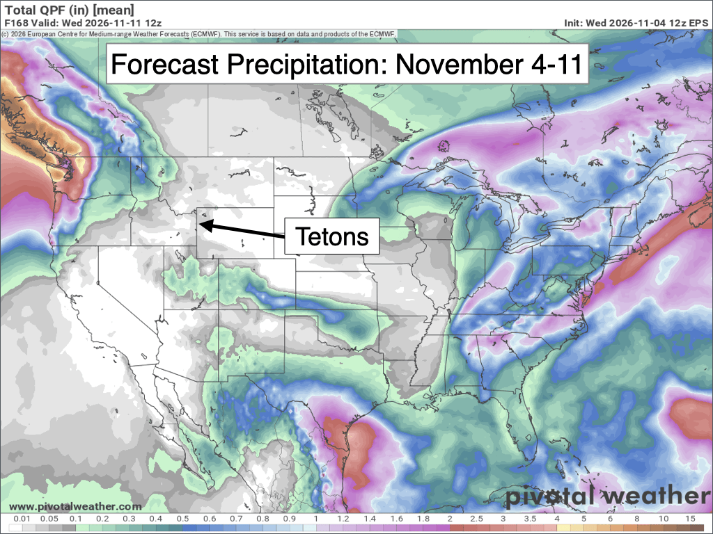
The pattern over the next week will be mild and dry, with virtually no precipitation expected. There is a slight chance we could see a few flurries or sprinkles sneak in on Thursday night, but that’s about it.
Temperatures have been seasonally cool this week with the added cloud cover, but more abundant sunshine is expected from this weekend into next week as a ridge of high pressure strengthens over the Interior West.
As a result, we will see highs well into the 50s most days, and possibly even into the low 60s on some days. Overnight lows will be colder, however, dipping into the upper teens to low 20s in the valley on nights with clear skies.
The 7-day precipitation forecast below represents the average of 50 simulations of the European Ensemble Model. Notice how the storm track will be focused over the Pacific Northwest, with dry conditions for our area.
November 2025 Outlook
We are now getting to the time of year when it will really begin to feel like winter as average temperatures quickly decrease and snow becomes more common. Mother Nature may not have gotten the memo this year (at least for the first half of the month), which we’ll discuss a bit more below.
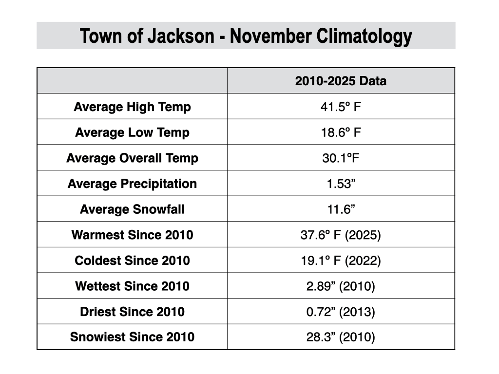
November is the fourth coldest month of the year on average in Jackson, with an average high of 41.5º and an average low of 18.6º.
We can still see a wide variation in temperatures, however, with mild snowless spells and cold snaps featuring subzero temperatures both possible at this time of year.
In the past 15 years, we have seen temperatures as warm as 65º (in 2020 and 2025) and temperatures as cold as -20º (in 2014) in the town of Jackson.
The town of Jackson averages 1.53 inches of precipitation and 11.6 inches of snow in November. The snowiest winter in town during the past 15 years was in 2010 with 28.3 inches.
In the Tetons, average snowfall in November is 76 inches at Grand Targhee and 58 inches at Jackson Hole Mountain Resort’s Rendezvous Bowl Plot. Data is courtesy of the Bridger-Teton Avalanche Center and BestSnow.net. The snowiest November at the Rendezvous Bowl Plot was 92 inches back in 2010.
Last year, we experienced an anomalously warm November, and this really set the tone for the entire winter, which was unusually mild.
So what does November 2026 have in store for us?
It’s perhaps a bit of an ominous start for skiers, with mild and dry conditions expected through at least November 12-13. However, there are some signs of a potentially more active pattern arriving around mid-month.
For the month as a whole, confidence is high that temperatures will be above average, though it probably won’t be as warm as last November.
Precipitation is more of a question mark, as most longer-range projections have equal chances of above or below average precipitation. However, I would lean toward below-average snowfall given the slow start to the month and the expected warm temperatures.
For what it’s worth, strong and east-based El Niño winters such as this one tend to favor slower starts to the winter (November-December), but with stronger mid to late seasons (January-March).
It will be interesting to see whether or not this winter follows a similar path.
Alan Smith, Meteorologist