


JACKSON, Wyo. – The warm and dry spell will come to an end this weekend as a storm system arrives, bringing cooler temperatures and the potential for heavy rain. Some snow is expected across the higher elevations Sunday-Monday, but considerable uncertainty exists regarding snow levels (the rain/snow line).
Recent Weather Pattern
The past week has featured abundant sunshine, warm afternoon temperatures, chilly mornings, and overall beautiful conditions. The last sunny/warm days of fall before the (often sharp) transition to colder, wetter, and snowier weather begins are arguably some of the best of the entire year in our area.
As nice as it has been, the extent of the afternoon warmth during the first week of October has been a bit unusual, yet also on par for 2026 which has been a very warm year as a whole.
Highs have been getting into the upper 70s to low 80s in recent days, including highs of 80ºF and 82ºF on Sunday and Monday, which are around record territory for this time of year.
In fact, these were the first 80+ degree days at the JKNW4 weather station in Jackson in October in 16 years. The latest 80 degree day record in Jackson occurred on October 11, 1996, so we will come up a few days shy of reaching this mark.
Despite the warm afternoons, morning lows have still been chilly with 50+ degree differences between low and high temperaturess on some days. It has been one of those stretches where you need winter clothes in the morning, and summer clothes in the afternoon.
Here is the 7-day weather summary for the town of Jackson:

For perspective, the average high and low temperatures in Jackson on October 7 are 63º and 29º.
Upcoming Weather Pattern
We have two more days of mild and sunny weather ahead on Thursday and Friday with highs well into the 70s in the valley. Winds will become strong on Friday afternoon, however.
These may be the last 70+ days until next year, and they may also be the last days with widespread dry trails in the mountains (before the fall mud season arrives), so get out and enjoy while you can!
Saturday is when things will start to change as a series of weather features will start to come together to bring cooler and wetter weather.
There is still some uncertainty as to whether or not we will get a weather window on Saturday morning, while there is growing confidence that showers will increase on Saturday afternoon and there is also a chance we could see a few thunderstorms.
There will be two main factors at play as we see our main weather impacts from Saturday PM to Monday AM…
First, a Pacific low pressure system originating in the Gulf of Alaska will deepen southward into Canada and the Northern U.S. Rockies with the polar jet stream, bringing cooler temperatures to our area over the weekend although a more significant shot of cold air will hold off initially.
While this system will bring significant snow to the eastern side of the Continental Divide in Montana and Wyoming (Absarokas, Winds, Big Horns), the Tetons and areas west of the Divide will have a different setup.
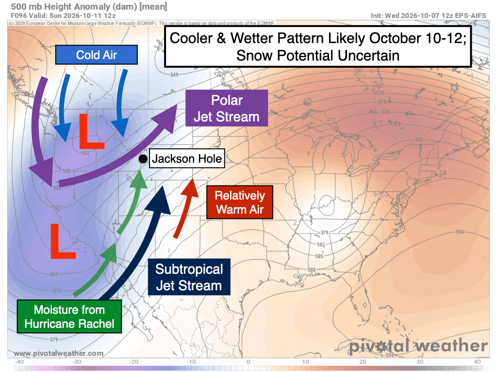
Second, an area of low pressure will develop off the coast of California this weekend, while at the same time, moisture from Hurricane Rachel in the Eastern Pacific will be pulled northward by the subtropical jet stream all the way into Western Wyoming.
Believe it or not, as Rachel tracks northward through cooler waters, there is a growing possibility that it will maintain tropical storm strength by the time it reaches Southern California on Saturday, which is something that would be a very rare occurrence.
Confidence is increasing that we will receive significant rainfall in the Saturday night to Monday morning window (exact timing subject to change) as this tropical moisture pushes into our area from the south.
The 7-day precipitation projection from the European Ensemble Model below represents the average of 50 simulations of the European Ensemble Model. Notice the orientation of heavy precipitation stretching from the Baja Peninsula all the way to Jackson Hole.
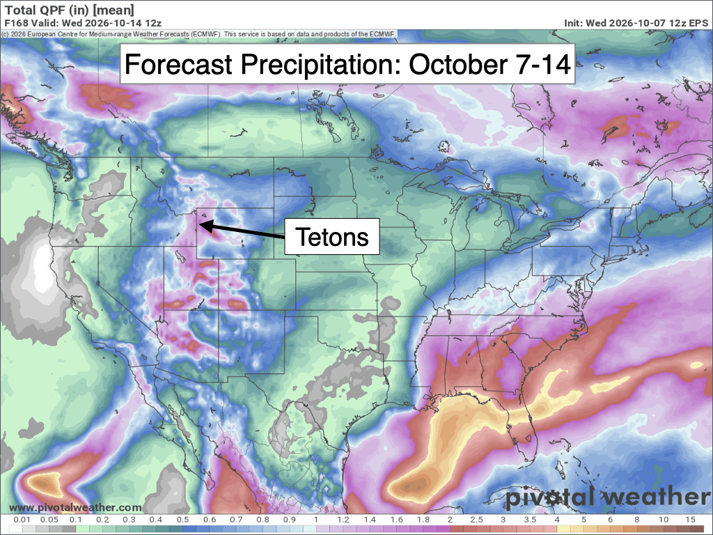
Temperatures will be much cooler on Sunday compared to previous days, but at the same time, the airmass associated with this tropical push will be mild enough that snow levels (the rain/snow line) will likely be on the higher side for most of this event, generally ranging from 9,500 feet to 11,000 feet, though there is certainly some wiggle room for this to change being 5 days out.
Monday is the big question mark as this is when model solutions diverge significantly with how these two weather features will interact with one another.
There is a chance that the southerly flow will continue to dominate and the northern system never makes it to our area, in which snow levels would stay high and Teton Pass would continue to see rain.
However, there is also a chance that a stronger cold front pushes through on Monday with the northern system maintaining strength, in which case snow levels could dip to Teton Pass or lower before precipititation ends.
There is even an outside chance that the valley could see a changeover to snow at the end of the event, but it’s a less likely outcome for now.
Bottom Line – Confidence is growing that a much cooler and wetter pattern will take hold from Saturday PM to Monday AM with significant precipitation possible.
But considerable uncertainty exists regarding snow levels, with recent trends indicating that the rain/snow line could remain high for most (if not all) of the event. If we do see a drop in snow levels to Teton Pass or lower, it would likely be on Monday morning.
Also, the situation will be much different on the east side of the Continental Divide, where colder temperatures and more significant snowfall is expected on Sunday-Monday.
Extended Outlook
Confidence in the pattern decreases around the middle of next week. There are some signs of another storm system moving through, which could potentially bring a shot of valley rain and mountain snow along with a reinforcing shot of cold air, but not all models are on board with this outcome yet.
The latest medium range model guidance favors below-average temperatures during the middle part of next week with highs in the 40s to 50s in the valley, before possibly warming up and drying out heading into the weekend of October 17-18.
Alan Smith, Meteorologist









