


JACKSON, Wyo. – Thunderstorms on Tuesday produced localized rain totals of over 2 inches in Driggs and at Jackson Hole Mountain Resort, with much of this rain accumulating in less than an hour. A Flood Watch remains in effect for Western Wyoming and Eastern Idaho through 6:00 am on Thursday.
Recent Weather
During the past week, we have been in a battle of airmasses. On the one hand, lingering hot temperatures have stuck around for the most part, even if less extreme than last week.
However, monsoonal moisture has also entered Western Wyoming from the south, leading to a more “humid” than usual airmass with high dewpoints, warm overnight low temperatures, and fuel for scattered heavy rain-producing thunderstorms.
The first surge of moisture arrived mid to late last week, with mainly isolated to scattered thunderstorms. The most active day was on Friday, when locally heavy rain of over an inch fell in Driggs, while Teton Pass and portions of the Jackson Hole Valley (north of town) received 0.5 to 1.0 inches.
From Saturday to Monday, we saw a lull in the pattern as deeper moisture shifted south and a hotter and more stable airmass returned. A little over a week after recording record highs in some parts of Teton County, we saw another unusually hot day this past Monday with a high of 94ºF in Jackson.
The next stronger surge of monsoonal moisture pushed into the area on Monday night and Tuesday, while significant heating of the lower atmosphere triggered numerous strong thunderstorms in the afternoon and evening.
Training of thunderstorm cells (multiple storms tracking over the same location) impacted Driggs and western and southern portions of the Tetons, where rainfall rates of 1-2 inches per hour occurred, which is very impressive for our region.
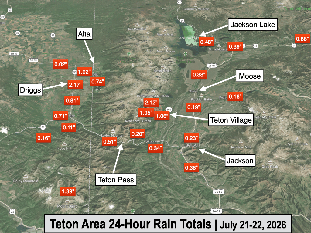
A rain gauge in downtown Driggs recorded a total of 2.17 inches of rain, with 1.49 inches of rain occurring within one hour. Amazingly, just north of Driggs, Tetonia only received 0.02 inches of rain, which lets you know just how fine a line it can be between heavy rain and little to no rain sometimes in these convective, hit-or-miss thunderstorm setups.
Two of the four rain gauges at Jackson Hole Mountain Resort also recorded over 2 inches of rain, and both of these stations also picked up about an inch and a half of rain in one hour.
Even more impressive, a rain gauge near Old Faithful in Yellowstone recorded a total of 2.72 inches of rain, including 2 inches in an hour!
Moisture levels, measured by precipitable water, or the amount of water vapor in the atmosphere, have been more than 200% of average on Tuesday and Wednesday, which, along with relatively weak winds aloft and slow storm motions, explains why these storms have produced such impressive rainfall rates.
These storms also produced quite a bit of lightning, although outside of the heavy thunderstorm core, rainfall was more modest. The town of Jackson received a total of 0.23 inches from 7 a.m. Monday to 7 a.m. Tuesday from multiple showers and thunderstorms.
Here are some notable rainfall totals recorded at rain gauges across the area from Tuesday’s thunderstorms:
- 2.72″ – Old Faithful
- 2.17″ – Driggs
- 2.12″ – Jackson Hole Mid Mountain
- 2.11″ – Jackson Hole Raymer
- 1.95″ – Jackson Hole Rendezvous Bowl
- 1.06″ – Jackson Hole Base
- 0.88″ – Togwotee Mountain Lodge
- 0.76″ – Grant Village (Yellowstone)
- 0.74″ – Alta
- 0.71″ – Victor
- 0.60″ – Alpine
- 0.51″ – Teton Pass
- 0.49″ – Jackson Lake
Here is a graphical view of rain totals across the Greater-Teton Area from Tuesday’s storms:
Here is the 7-day weather summary for the town of Jackson:

For perspective, the average high and low temperatures in Jackson on July 22 are 83º and 45º.
Notice how warm the nights have been in Jackson recently. This is due to a combination of a warmer-than-average airmass, plus higher moisture levels than usual, which have prevented temperatures from dropping much at night.
Upcoming Weather Pattern
Showers and thunderstorms have been slow to develop on Wednesday, with nothing much happening yet as of late Wednesday afternoon.
While a shortwave disturbance is moving across the Central Rockies and abundant moisture remains in place, there are some stable layers in the atmosphere that have suppressed the development of convective precipitation thus far.
Showers and thunderstorms are still expected to develop during the evening hours (possibly late evening) as the best “energy” from the shortwave disturbance arrives, even if later than previously forecast.
However, a “busted pattern” can’t be ruled out either, as thunderstorm setups are often finicky and can boom or bust depending on small differences in the “ingredients”.
Any thunderstorms that manage to develop on Wednesday evening will have the potential to produce significant rain, although heavy amounts will probably be localized once again. The highest threat of flash flooding would be with any “training” of thunderstorms, which refers to multiple storms re-developing and tracking over the same area.
On Thursday, we may see some showers in the morning followed by a chance of thunderstorms in the afternoon, but overall the pattern looks to stabilize a bit compared to recent days.
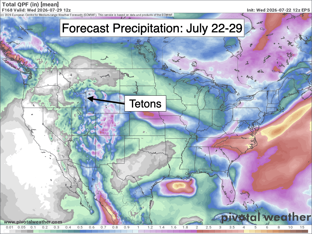
From Friday through early next week, a monsoonal flow will resume, leading to near-daily chances of afternoon thunderstorms, some of which could produce locally heavy rain, but probably not to the extent of what we saw on Tuesday (and could theoretically see on Wednesday evening).
Recent trends are indicating a somewhat stronger pulse of moisture on Saturday compared to the rest of the weekend/early next week, so we could potentially see stronger thunderstorms as a result.
The image below is a 7-day rainfall projection from the European Ensemble Model, which represents the average of 50 simulations of this model.
Despite the monsoonal flow, it looks like temperatures are going to quickly return to above-average levels after a break from the heat on Wednesday. From Friday through early next week, we are looking at upper 80s to low 90s for highs in the valley each day.
Looking further out, the monsoonal flow should continue through the end of July, then there are some longer-range signals suggesting we see a break in the monsoon pattern in early August, though confidence is low this far out. Temperatures also look to stay above average for the foreseeable future.
Alan Smith, Meteorologist











