
JACKSON, Wyo. – Significant monsoonal moisture has reached Teton County and will set the stage for an extended period of wet conditions from Wednesday through the early part of next week. Temperatures will also be much cooler compared to recent weeks.
Wet Pattern Taking Hold
An initial surge of monsoonal moisture arrived on Monday, providing an “appetizer” for our area with scattered thunderstorms that produced hit-or-miss heavy rain.
For example, a thunderstorm late Monday afternoon resulted in a brief period of heavy rain in the town of Jackson, but even within town, rainfall amounts varied. A rain gauge in East Jackson received 0.40 inches of rain (and 0.35 inches in only 15 minutes), while on the north side of town by the visitor center, only 0.25 inches were recorded.
A brief period of more stable air aloft prevented thunderstorms from developing on Tuesday, but our wet pattern is already taking shape on Wednesday morning.
Significant moisture arrived overnight from the south, aided by a disturbance in the upper atmosphere. This is resulting in widespread rain on Wednesday morning with rainfall rates picking up as the day progresses.
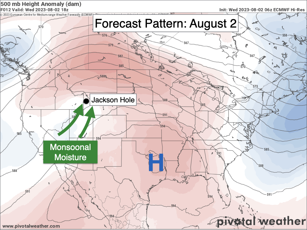
Wednesday and Thursday, and to some extent Friday, will be the wettest days in this pattern with widespread off-and-on showers expected both day and night. The combination of moisture along with embedded disturbances will result in significant rainfall amounts adding up over time.
Temperatures are also going to be much cooler from Wednesday through Friday with highs only in the 60s in the valley! This is a significant change following 17 consecutive days with highs in the 80s.
Average highs in Jackson in early August are in the low 80s so we will be well below average. Low temperatures will be slightly above average, however, given the high levels of moisture in place.
The amount of water vapor in the atmosphere will be about 200% of average on Wednesday and Thursday, or about three standard deviations above average.
This level of moisture will also result in at least a chance of excessive runoff and flash flooding on a localized/isolated basis this week.
Cooler air and cloud cover may be a limiting factor to the instability needed for very heavy rainfall rates to occur. But if consistent heavy showers or thunderstorms manage to develop, then areas of steep/rocky terrain as well as small streams will be more susceptible to runoff issues.
The highest threat of excessive runoff and flash flooding will be on Thursday, due to three reasons: 1) Significant moisture levels and potential for heavy rainfall rates, 2) Previously saturated soils from Wednesday’s rain, and 3) Slow and erratic storm motions which could result in heavy showers/storms remaining over an area for a longer period of time.
On Friday, moisture levels will decrease and storm motions will also be faster, but we will still have plenty of moisture in place for frequent showers and thunderstorms along with the potential for shorter-lived heavy rainfall rates at times.
If you’re hoping for nicer weather this weekend, you may be in for a disappointment. Additional disturbances will track across our area as a strong jet stream works its way into the Central Rockies, interacting with lingering monsoonal moisture to result in additional showers and thunderstorms.
This pattern will likely continue into the early part of next week as well (Monday and Tuesday).
Rainfall from Saturday through Tuesday will likely be more intermittent compared to prior days with less rainfall overall. However, it still looks like an active pattern with locally heavy rain possible at times, and rain could also occur both day and night.
Temperatures are expected to be slightly warmer this weekend with highs in the low 70s. If we see more breaks in cloud cover, then we could see enough solar radiation to result in more lightning activity compared to prior days.
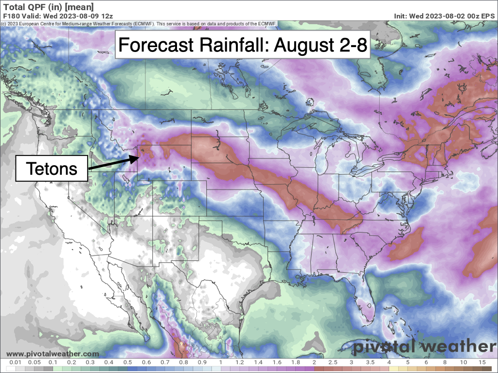
Here are projected rainfall totals over the next 7 days from an average of multiple simulations of the European Weather Model. This is an impressive pattern for us by August standards!
Extended Outlook
Starting around the middle of next week (August 9), we should start to see a trend toward drier and warmer weather heading into mid-August. However, when exactly this drying trend begins, the extent of the drying trend, and the timing/extent of the warming trend are all uncertain.
We may simply trend back to seasonal temperatures for mid-August (low 80s) as opposed to the above-average warmth experienced in mid to late July.
July Review
July ended up warmer and drier than average in Teton County and across Western Wyoming. We did have some eventful thunderstorms during the month, however, especially early and late in the month.
During the first week of the month, severe thunderstorms produced wind damage in Teton Valley, Idaho as well as the Lake Village in Yellowstone National Park. A strong thunderstorm also stalled over Victor on July 8, resulting localized flash flooding.
However, most areas only received light rainfall in early July while all areas experienced a dry pattern in mid-July.
Toward the end of the month, we started to see some monsoonal moisture intrusions with an uptick in thunderstorm activity along with comparatively heavier and more widespread rainfall.
A severe thunderstorm impacted Wilson and Jackson on July 24 with rainfall totals of 0.25 to 0.50″ throughout Teton County. A few days later, on Thursday, July 27, a strong disturbance interacting with monsoonal moisture resulted in several rounds of early morning thunderstorms across Teton County.
For the month as a whole, Jackson only received 0.55 inches of rain, which is about 50% of average. However, this does not include rain that fell on July 31 since 24-hour rainfall and snowfall reports are recorded at 7 am or 9 am each morning depending on the reporting source – meaning that rainfall on the afternoon of July 31 was “counted” on the rainfall report for August 1.
Elsewhere around Teton County, rainfall totals in July included 0.53 inches in Alta, 0.76 inches in Moose, and 1.16 inches at the Moran/Jackson Lake weather station. Moran is the one location that recorded average rainfall in July while most other areas were below average.
Most areas of the West saw below average rainfall in July. A late start to monsoon season resulted in well below average rain in the Southwest, while rainfall was near to above average east of the Continental Divide in Wyoming and Colorado.
Also, note that Coastal California averages very little rainfall in July (some areas average no rainfall), so it only takes a little bit of rain there at this time of year for above-average anomalies to show up.

Temperatures were also warmer than average in Jackson and across Teton County during July, but not as warm compared to the previous two Julys (2021 and 2022).
The average high in Jackson in July 2023 was 83.5ºF compared to a long-term average of 82.4ºF, and the average low in Jackson was 43.7ºF compared to a long-term average of 41.2º. Overall, temperatures in July 2023 were 1.8ºF above “normal.”
Temperatures at the Moran/Jackson Lake weather station were 0.9ºF above normal in July, so only slightly warmer than what is typical.
Believe it or not, this was only the second month this year with above-average temperatures, the only other month being May.
As far as “extremes” go, the hottest temperature during the month of July in Jackson was 93ºF on July 23, and the coldest temperature was 37ºF on July 6. There were three days total in which the high reached 90ºF.
Temperatures were generally hotter than average across the West, except for areas near and east of the Divide in Wyoming, Southern Montana, and Colorado where temperatures were near average. Many areas in Arizona and New Mexico experienced their hottest July on record.

Alan Smith, Meteorologist


