
JACKSON, Wyo. – Gusty winds this week are contributing to the rapid growth of the Fish Creek Fire near Togwotee Pass. On Friday, thunderstorms could produce locally heavy downpours, but also gusty outflow winds. Much cooler air arrives Saturday-Sunday, but rain chances are uncertain.
Recent Conditions and Fish Creek Fire
Showers and thunderstorms in August have brought heavier rainfall to most of Teton County compared to June and July, which were both very dry. However, lightning also triggered the Fish Creek Fire near Togwotee Pass – an area that has not seen as much rainfall over the past week compared to the rest of Teton County.
On Sunday night, a large cluster of showers and thunderstorms impacted the Tetons and Jackson Hole, bringing 0.2 to 0.8 inches of rainfall to the area.
Unfortunately, the eastern fringe of this activity fell apart just to the west of Togwotee Pass, and as a result, the fire experienced prolonged gusty and erratic outflow winds from the thunderstorms with little rain.
Additional storms to the south and west of Togwotee Pass also produced gusty and erratic outflow winds last weekend and earlier this week that exacerbated fire conditions.
During the middle part of this week, a drier pattern has taken hold but winds have been quite strong, allowing the fire to continue growing.
Wyoming is currently situated between a warmer airmass to the south and east and cooler airmass to the Pacific Northwest. A tight pressure gradient (rate of pressure change with distance) separating these two airmasses is contributing to the strong winds.
Smoke from the Fish Creek Fire has been settling into the lower elevations during the early morning hours and briefly spilling through lower drainages into the Central Jackson Hole Valley, typically to Jackson Lake and southward to around Moose, before dispersing by late morning as the days heat up and air near the surface begins to rise.
Ironically, there has been much less smoke overall across Jackson Hole and the Tetons over the past 10 days compared to prior weeks. Winds aloft across the Western U.S. have shifted from predominantly westerly to predominantly southwesterly, which is pushing most of the smoke from fires north of our area.
Also, recent cooler temperatures and wetter conditions have led to a reduction in fire intensity across the Pacific Northwest, though several large fires continue to burn in Central Idaho.
The Jackson Hole Valley has also received decent rainfall during the past couple of weeks, unlike June and July. The town of Jackson is up to 1.22 inches of rain so far in August and measurable rain has occurred on 10 days this month.
With 10 days to go in the month, there is a chance we could reach our August average of 1.48 inches before the end of the month, but it could be a close call given the hit-or-miss nature of rainfall at this time of year.
Upcoming Weather Pattern
Gusty winds will be a daily weather feature through at least Sunday, but we will also see some precipitation chances late this week along with cooler temperatures as an active pattern develops.
In fact, we have several weather features to keep an eye on…

(1) A good chance of thunderstorms is expected on Friday as a surge of monsoonal moisture arrives from the south.
Moisture will initially arrive on Thursday evening with a slight chance of late afternoon and overnight showers and thunderstorms.
A slight chance of showers and thunderstorms will exist on Friday morning as well, with a higher likelihood of thunderstorms on Friday afternoon. Storms will have the potential to produce frequent lightning and locally heavy rain, along with small hail and gusty winds.
This will be hit-or-miss rainfall and storms will be fast-moving, so it will take some luck for the Fish Creek Fire to see any prolonged meaningful rain (multiple storms would need to pass directly over the fire), and the side effect of gusty outflow winds could make things worse in terms of fire spread and intensity.
(2) A strong cold front will arrive during the day on Saturday.
This will result in a significant cool-down with early fall-like temperatures expected. Currently, the front is projected to arrive on Saturday with highs in the low to mid 70s in the valley.
On Sunday, highs are only projected to reach the low to mid 60s in the wake of the front, though there is still some uncertainty with some models projecting a stronger push of cool air than others.
On Sunday night and Monday morning, we could see our first freeze of the season in the valleys as skies clear out in the wake of the front. This wouldn’t be at all unusual, as the average first freeze of the season in Jackson is in late August.
Be prepared for cooler temperatures if you have outdoor plans this weekend, especially at higher elevations where temperatures could be very chilly.
Gusty winds are expected to continue this weekend as well, which will favor active fire behavior with the Fish Creek Fire through at least Saturday. Cooler air and higher relative humidity on Sunday should help with firefighting efforts, though winds are still expected to be gusty so it’s not all good news.
(3) Some showers and thunderstorms are possible on Saturday-Sunday, but confidence is low.
The most challenging part of the weekend forecast has to do with moisture and precipitation chances.
A trough of low pressure (associated with the cold front) will move across the Northern Rockies and some Pacific moisture will be moving through with this trough. However, models are in poor agreement on the north vs. south extent of the trough and whether or not much of this moisture reaches the Tetons and Jackson Hole (and Togwotee Pass).
Overall, recent model trends have been backing off on precipitation amounts and coverage, but there is still plenty of uncertainty.
For now, there is at least a chance of showers (and possibly thunderstorms) from Saturday afternoon through Sunday evening.
The most likely scenario is for scattered/occasional light showers in the Tetons with lesser chances to the south in the Winds. But there is a high-end/lower-probability scenario that could result in more widespread soaking rains on Saturday night and Sunday, while there is also a low-end scenario where conditions remain dry with no rain at all.
Keep a close eye on weather forecast trends in the coming days if you have outdoor plans this weekend…
Also, IF we manage to see any precipitation this weekend, there is a chance that snow could fall across the higher elevations on Saturday night and Sunday. In fact, some models project snow levels to dip as low as 10,000 feet by early Sunday, meaning the potential exists for the peaks and higher passes to get dusted with snow.
Here is a 7-day precipitation projection representing the average of 50 simulations of the European Model. Locally, this accounts for Friday’s monsoonal thunderstorm chances and Saturday-Sunday’s frontal system shower chances.
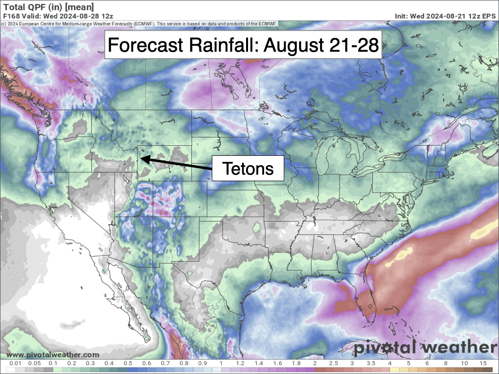
Outside of the Tetons, widespread precipitation is expected across the Pacific Northwest and far Northern Rockies, and also across the Southern Rockies (Arizona, Utah, and Colorado) where a significant monsoon moisture surge will lead to heavy rain and possibly some flash flooding.
Extended Outlook
Dry conditions will return early next week with possible frosty conditions on Monday morning giving way to warmer temperatures by Monday and Tuesday afternoons (highs near 80 by Tuesday). A relative lull in the windy conditions is possible on Monday, but then winds could increase again as early as Tuesday.
A low pressure system is projected to pass north of our area around mid-week (August 27-28) which could result in more wind, while precipitation appears unlikely at this time. A brief mid to late-week cooldown is also possible.
Longer range models are hinting that monsoonal moisture could return over Labor Day weekend, which would result in thunderstorm chances.
Alan Smith, Meteorologist


