
JACKSON, Wyo. – The first accumulating snow event of the season below 10,000 feet is expected in the Tetons late this week as a storm system impacts the area. Chilly temperatures and significant rainfall can also be expected across the lower elevations.
Upcoming Weather Pattern
A low pressure system is working its way southward into the Northwest U.S. from Canada as of Wednesday, and this system will impact Western Wyoming over the next several days. Cooler air will gradually filter into the region with falling snow levels (i.e. the rain/snow line) on Thursday and Friday.

We are still on the milder leading edge of the system on Wednesday, as scattered showers and thunderstorms have developed across the area during the afternoon hours. Showers have generally been producing light and spotty rainfall, along with small hail, as of mid-afternoon.
The pattern will gradually become wetter with more widespread showers developing from Wednesday night through Thursday night, along with occasional thunderstorms. High temperatures will only reach the upper 50s in the valley on Thursday after topping out in the mid 60s on Wednesday.
Snow levels will start out ranging from 10,000-11,000 on Wednesday night and Thursday, before lowering slightly to 9,500-10,500 feet on Thursday night.
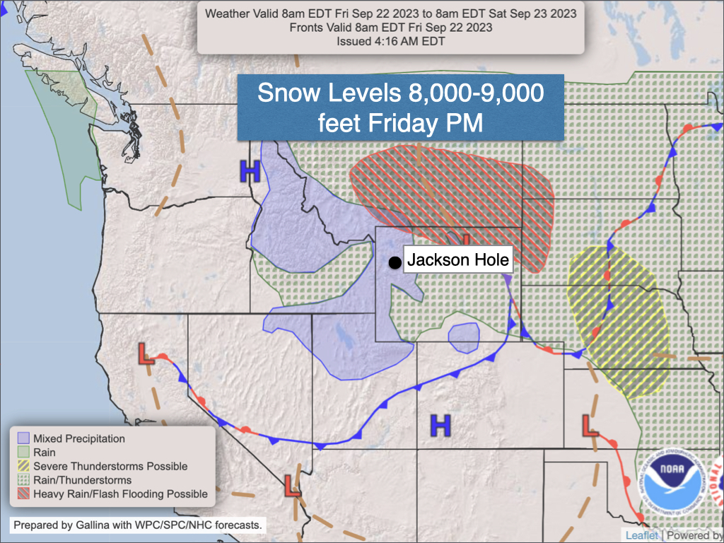
On Friday, colder air will filter into the region with continued widespread showers along with falling snow levels. High temperatures will struggle to get out of the 40s in the valley on Friday with cold and wet conditions expected in the backcountry.
Snow levels will dip to 9,000-10,000 feet during the morning hours, before falling to 8,000-9,000 feet during the afternoon and evening hours. Even Teton Pass could see some snow falling by late in the day, though accumulations will most likely be minor and limited to grassy surfaces near the top of the pass.
Rain and snow showers will become lighter and more intermittent on Friday night and Saturday morning before eventually tapering off later in the day on Saturday. Temperatures will remain chilly on Saturday with highs in the mid 50s in the valley.
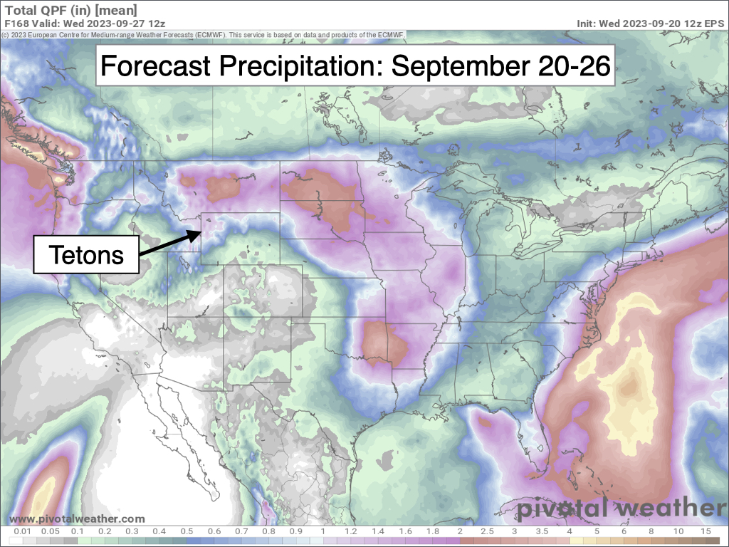
Total precipitation (rain and liquid-equivalent snow) through Saturday will range from 1 to 2 inches in the Tetons and surrounding mountain ranges of Northwest Wyoming, and 0.5 to 1.5 inches in the valleys.
Areas above 9,000 feet could see anywhere from a dusting to a few inches of snow from Friday PM through Saturday AM, with light dustings possible as low as 8,000 feet. Moving up in elevation, several inches of snow will be possible above 10,000 feet.
Here is a 7-day precipitation outlook, which accounts for the Wednesday-Saturday storm system:
Once this system exits, we will head into a warmer and drier pattern from Sunday through Tuesday. Highs will reach the 60s on Sunday and low 70s on Monday and Tuesday.
Extended Outlook
Long-range models are hinting at another fall low pressure system approaching our area late next week (September 28-October 1 timeframe). While confidence is low this far out, we may see a trend toward cooler temperatures and increased precipitation chances (valley rain/mountain snow) during this period.
September Weather So Far
Last weekend (September 16-17), we finally got our perfect September weekend with clear skies, no precipitation, and comfortable temperatures with highs in the 70s and lows near freezing.
So far this month, temperatures are running 1.4ºF above normal in Jackson, mainly due to overnight lows being milder than normal up until recently. High temperatures have been right around normal with average values in the low 70s.
While highs in the 70s have been typical so far this month, at this point it’s very likely we will make it through the end of the month without hitting 80ºF in Jackson. This is unusual, as typically we hit 80ºF at least once during September.
Also, this is quite a contrast to last year, when we experienced a late-season heat wave and hit 90ºF five times during the first week of September (this was also highly unusual).
As far as rainfall goes, we received about an inch in the valley over Labor Day weekend, but have received very little rainfall since then – just some light and spotty showers that have generally produced trace amounts.
Even so, with the upcoming storm system late this week and another possible storm system toward the end of the month, there is a good chance we will exceed our September monthly rainfall average of 1.60 inches this year.
Note: I will be traveling next week and will not be posting a Wednesday weather article. My next article will be on Wednesday, October 4.
Alan Smith, Meteorologist


