


JACKSON, Wyo. – The southwest monsoonal flow that has been in place recently will give way to a drier westerly flow this weekend, with temperatures heating back up. Relatively cooler temperatures will arrive next week, but wildfire smoke from Oregon may also impact Western Wyoming at times.
Recent Weather
Monsoonal moisture has been in place during the past week, while shortwave disturbances associated with a low-pressure trough over the Pacific Northwest have helped to generate near-daily rounds of showers and thunderstorms.
Thunderstorms have been faster-moving, so we have not experienced the same kind of locally heavy rainfall rates that we did last week, but the more widespread, frequent showers and higher relative humidity values are always welcome at this time of year to keep fire danger at bay.
Despite this monsoonal flow, a high pressure ridge over the Northern Rockies has continued to flex on some days, leading to periods of unusually hot temperatures across our area.
The latest heatwave peaked on Saturday and Sunday with highs of 91º and 95º recorded at the JKNW4 weather station in Jackson. This is the second time the JKNW4 weather station has hit 95º or higher this July, after hitting 95º only once in the previous 16 years combined.
The past few days have featured more abundant cloud cover and cooler temperatures. On Tuesday, the high temperature briefly spiked to 89º during a sunny stretch mid-afternoon before late afternoon thunderstorms cooled things again.
But our stretch of unusually mild overnight temperatures has continued. It’s not unusual for the town of Jackson to have lows in the 50s when moisture is present, even though our average lows in July are in the 40s.
However, we have only had one day in the past 16 days in which the low temperature in Jackson (JKNW4 weather station) dropped below 50º, a stretch that is very unusual.
Here is the 7-day weather summary for the town of Jackson:

For perspective, the average high and low temperatures in Jackson on July 29 are 84º and 45º.
Upcoming Weather Pattern
Monsoonal moisture will linger but gradually decrease late this week before drying out completely this weekend and next week.
Another round of showers and thunderstorms is possible on Wednesday evening, followed by isolated afternoon thunderstorms on Thursday and Friday with temperatures starting to heat back up.
Starting on Saturday, the monsoon will weaken significantly and retreat southward. This is because the high pressure center over the Southwest U.S. that monsoonal moisture rotates around will shift too far west, cutting off the flow of moisture, while a trough with strong winds aloft passing across the Northern Rockies in the days to follow will also help to weaken the monsoon.
On Saturday, the heat will also build substantially across Wyoming, with highs soaring into the mid 90s in the Jackson Hole Valley once again.
On Sunday, winds will become strong in advance of an approaching cold front, and the strengthening westerly winds aloft could also bring some wildfire smoke into our area from Oregon.
The dry and windy pattern will also increase our local fire danger, though recent moisture should help to keep it from being an exceptionally high fire danger day at least (not to discount the risk; this is just to say it would be worse if we had already been in an extended dry spell).
The cold front will arrive later Sunday/early Monday, and this will help to take the edge off of the heat with highs in the low to mid 80s most days during the first half of next week.
The downside is that the shift in upper atmosphere wind direction to westerly will increase our risk of wildfire smoke intrusions from Oregon.
Currently, there has been some decrease in fire intensity across Oregon on Wednesday, but the weekend wind event across the Northwest could potentially exacerbate fire behavior again, putting our area at risk of downwind smoke impacts.
The image below is a 7-day rainfall projection from the European Ensemble Model, which represents the average of 50 simulations of this model. Mostly light rain amounts are showing up across Western Wyoming and Eastern Idaho from hit-or-miss showers and thunderstorms from Wednesday to Friday of this week before the dry spell takes hold.
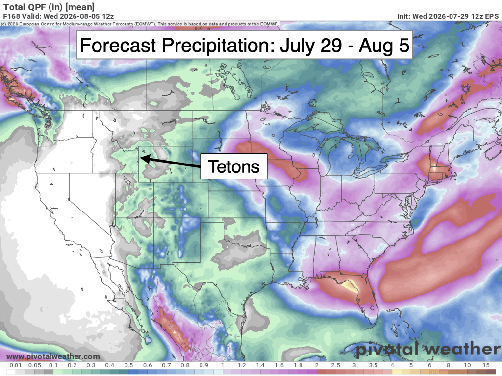
Looking further out, this dry spell is expected to last through approximately Sunday, August 9.
Starting around August 10, long-range models have been in good agreement with a strengthening Southwest Monsoon sending moisture back into our area from the southwest. This would lead to increasing shower and thunderstorm potential heading into mid-August.
Alan Smith, Meteorologist









