
JACKSON, Wyo. – A very dry weather pattern has taken hold across Western Wyoming with gusty winds and low relative humidity. This pattern will continue over the next week with minimal rain potential.
Recent Weather Pattern
Other than some afternoon thunderstorm activity over the crest of the Teton Range during the middle of last week, the pattern during the previous seven days has been very dry with Pacific disturbances tracking too far north of our area.
The monsoon has also been a no-show across the Southwest in recent weeks, which is typically a source of moisture and thunderstorms for our area at this time of year.
An active jet stream across the Northern Rockies has also supported windy conditions each afternoon this week. Fortunately, we have not seen any new significant wildfires locally during this stretch yet, but the fire danger is growing as long as we stay in this dry and windy pattern.
The relative humidity at the Jackson Hole Airport as of this writing on Wednesday afternoon is 12% with winds gusting to 28 mph. These weather conditions are conducive to wildfire spread in the event of any new fire ignitions.
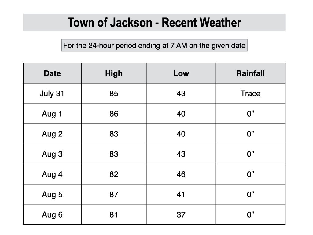
Temperatures over the past week have been fairly seasonal, with highs in the 80s and lows in the 40s. A cold front did move through on Tuesday, however, and low temperatures dipped into the upper 30s in Jackson on Wednesday morning.
Fire danger aside, the weather has been ideal for outdoor recreation lately with minimal thunderstorm potential and seasonal temperatures. We also have not had any significant wildfire smoke in the area yet this summer, which is a welcome change from last summer (with the caveat that this could always change).
Upcoming Weather Pattern
Over the next week, more of the same can be expected with dry conditions and gusty winds as frequent low pressure troughs continue to pass across the Northern Rockies. Once again, any appreciable moisture with these systems will stay north of our area.
A brief cool-down is heading our way late this week, however.
A cold front will move through on Thursday night, and there is a slight chance of some light overnight showers, though it’s possible that most areas end up with no measurable rain.
On Friday, highs will only reach the low 70s behind the front. Thursday will mark our 32nd day in a row with a high temperature of 80ºF or warmer in Jackson, which is an impressive streak for our area. That streak is expected to come to an end on Friday.
Saturday also looks like a comfortable day with highs in the mid 70s, before warming up to near 80 on Sunday and into the mid 80s on Monday and Tuesday.
Overall, the weather pattern will remain ideal for outdoor recreation. But fire danger will also remain high with gusty winds expected each day. Also, there is always a chance we could see wildfire smoke if there are any new large fires that start nearby or upwind of our area, but let’s keep our fingers crossed that this doesn’t happen.
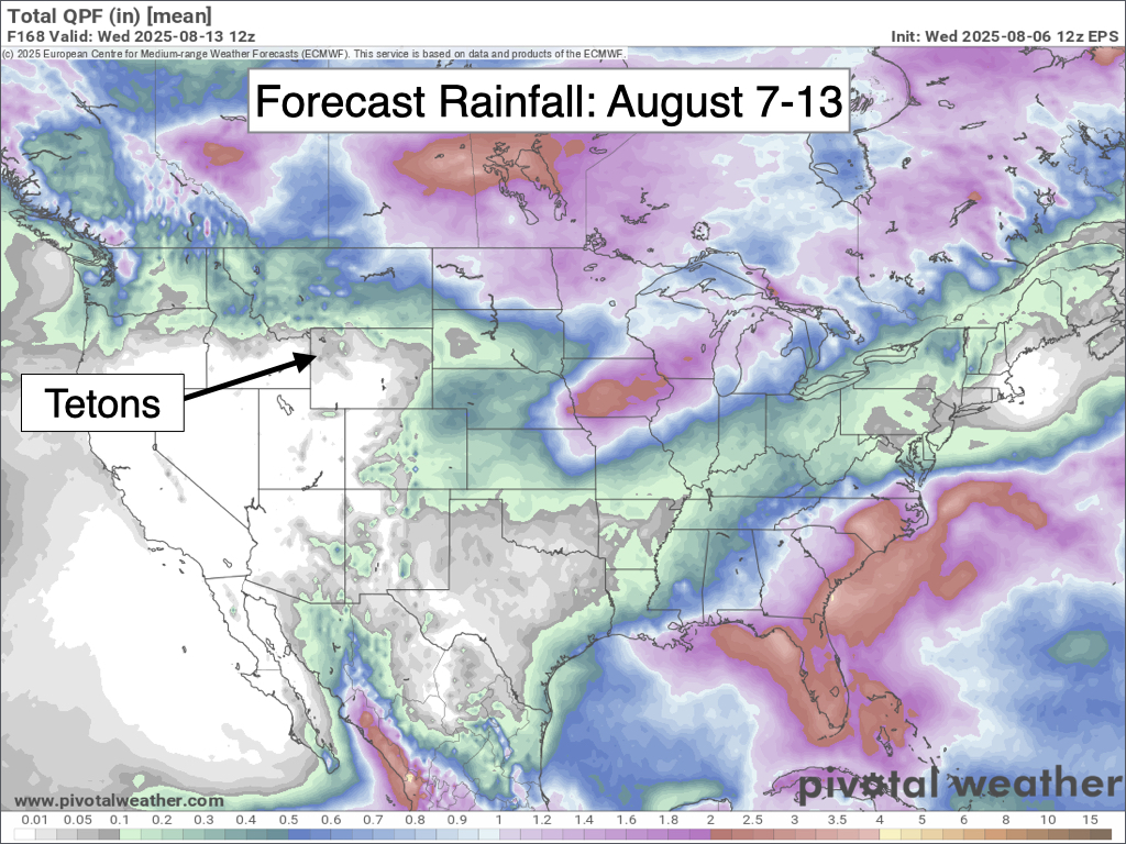
The European Ensemble Model’s 7-day precipitation projection indicates little to no precipitation in our area, with heavier rainfall north of our area. The monsoon is also expected to remain very weak over the Southwest.
Looking further out, there are some hints that the monsoon will strengthen somewhat over the Southwest around the middle of next week, with moisture increasing across Arizona and Utah.
And there is also a chance that some of this moisture could sneak into our area later next week, potentially leading to thunderstorm chances and perhaps even some measurable rainfall (but also a risk of lightning-triggered wildfires). However, confidence is low this far out.
Alan Smith, Meteorologist


