
JACKSON, Wyo. – Following a very dry June and July, rainfall and temperatures were right around average in Jackson Hole during the month of August. Although the summer season is gradually winding down, warmer and drier-than-average conditions are expected in September.
August 2024 Recap
August was more active compared to June and July, with showers and thunderstorms occurring more regularly.
The town of Jackson received 1.60 inches of rain in August, which is slightly above the 15-year average of 1.48 inches. Measurable rainfall (more than a trace) was recorded on 13 days.
However, this also ended an impressive three-year streak from 2021 to 2023 in which Jackson received more than 3 inches of rain in August. This was merely an “average” August in terms of rainfall.
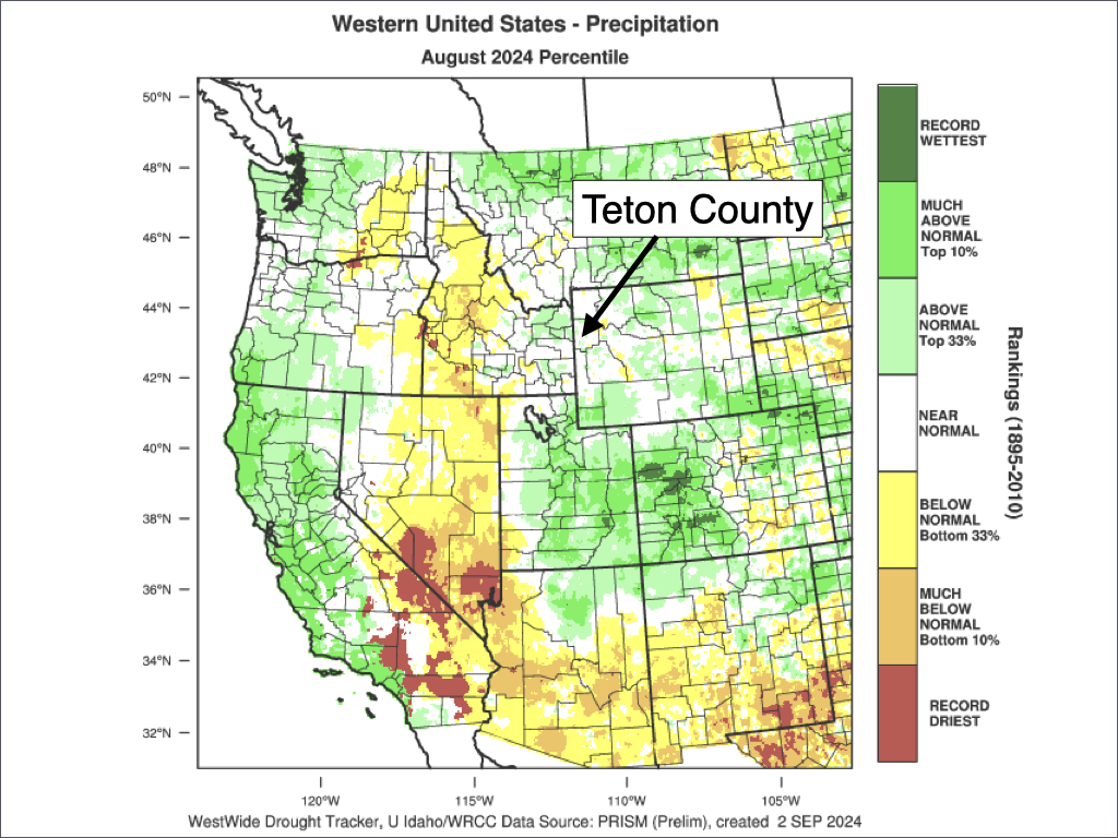
Rainfall tends to be hit or miss in nature at this time of year due to the convective “pop-up” nature of showers and thunderstorms. However, most areas in Teton County ended up close to average.
For the Western U.S. as a whole, rainfall was above average to our south across Utah and Colorado as well as in the Pacific Northwest and over a good portion of Montana. Rainfall was below average across Central and Western Idaho, where some of the largest and most active wildfires are currently burning.
Even though we saw decent moisture at times in August, hot and dry conditions in June and July resulted in high fire danger. The Fish Creek Fire near Togwotee Pass was triggered by lightning in August and has grown to nearly 20,000 acres as of early September.
Showers and thunderstorms can be a good or bad thing in terms of fires at this time of year. Rainfall is good, of course, but lightning and gusty outflow winds that occur on the outskirts of thunderstorms (or in dry thunderstorms that produce little rain) can be very bad news for fire behavior.
Gusty and erratic outflow winds (on multiple occasions) were a significant driver of fire behavior during the early stages of the Fish Creek Fire.
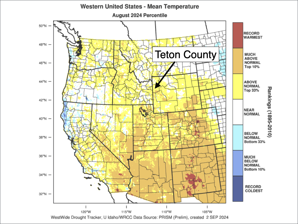
In terms of temperatures, we ended up near to slightly above average across Teton County in August, but with high variations in temperature swings over the course of the month.
During the first few days of August, a significant heat wave occurred with some of the hottest temperatures in the area in over 20 years. The town of Jackson recorded a high of 95ºF on August 3.
Jackson averages about four 90-degree days per year (based on 15-year data), but 95-degree days are rare. For the summer of 2024, Jackson has hit 90-degrees on 11 days, with eight of these days occurring in July and three in August.
Despite the higher number of “extreme” heat days (extreme being a relative term for this area) this summer, overall temperatures in July and August have been very close to average as we have also seen a number of cool snaps.
For instance, a mid-August cool snap occurred which included a high of only 63ºF on August 13. We also saw a period of cooler weather toward the end of the month, which included a little bit of snow above 10,000 feet on the morning of August 26.
The valley also saw its first widespread freeze of the season on August 29 with a low of 28ºF recorded in Jackson. This is actually right around average for the first freeze of the season.
For the month as a whole, temperatures ended up 0.5 degrees above “normal” in Jackson with an average high of 80.9ºF and an average low of 42.8ºF.
For the Western U.S. as a whole, temperatures were near to slightly above average across the Northern Rockies and Northwest, and well above average across the Southwest.
Current Weather Pattern
While we saw an early taste of fall in late August, the first two days of September were very warm with Jackson hitting 88ºF.
Of course, longer nights at this time of year along with low relative humidity have promoted strong radiational cooling in the valleys where temperature inversions are typical (cool/dense air settling in the valleys at night).
We have had several days of 50+ degree temperature swings between day and night, with lows well into the 30s and highs well into the 80s.
On Tuesday (September 3), a weak trough of low pressure approached our area from the west, providing enough moisture, energy, and instability (warm air near the surface and cold air in the upper atmosphere) to trigger showers and thunderstorms.
Some of the storms that passed over the Tetons were quite strong, producing frequent lightning, heavy downpours, and hail.
Rainfall totals across the area generally ranged from 0.05 to 0.25 inches. However, the strongest storms passed over areas with poor rain gauge coverage, so there were likely higher rainfall amounts that were just not measured.
Temperatures are a little bit cooler on Wednesday in the wake of a cold front that moved through behind Tuesday’s system. However, we will trend back into a warm and dry pattern from Thursday into the weekend with highs in the 80s.
From Sunday into early next week, another weak trough of low pressure will approach which could bring some isolated to scattered showers and thunderstorms, but with spotty rainfall amounts.
Here is a rainfall projection for the next seven days:

September Outlook
September is the fourth warmest month of the year in Jackson Hole, and arguably the nicest month of the entire year as summer’s heat is waning and the bugs are gone, while the mountains are (usually) not snowed in yet, allowing for prime conditions for outdoor recreation.
In the town of Jackson, the average high in August is 73ºF and the average low is 35ºF based on the previous 15 years.
Highs in the 90s are atypical in September, but it has happened on a few instances in early September in recent years. Highs in the 80s are still relatively common in early to mid-September. The average last 80-degree day of the year is September 18.
Freezing temperatures in the valleys also occur with more regularity on clear/calm nights the later we get into September.
Clear, calm days are the norm at this time of year as afternoon thunderstorms are less frequent compared to July and August due to cooler temperatures and less solar radiation as the days get shorter.
However, stretches of cool, wet, stormy, and inclement weather are also not uncommon at this time of year. Cool season low pressure systems begin pushing into the Northwest U.S. on occasion at this time of year, and this can bring periods of heavy rain to the area along with high-elevation snow.
Although thunderstorms are less frequent, there are still an average of 6 thunderstorm days in the Tetons in September, with thunderstorm activity more likely to be associated with low pressure systems (such as what occurred on Tuesday).
New snow that falls across the higher terrain in the Tetons in September typically melts off within a few days over most passes and on some peaks, but shaded north-facing terrain on the higher peaks may remain snowy and icy for a long time after an event.
On average, the frequency of rain/precipitation is lower in September compared to other months (extended stretches of sunny days are common), but when precipitation does occur, it is often heavier and more widespread compared to other non-winter months.
Jackson averages 1.65 inches of rain in September, but this is highly variable from year to year depending on the frequency of low pressure systems. For example, in 2018 Jackson received a paltry 0.05 inches of rain, while the very next year (2019), Jackson received 3.45 inches of rain.
Accumulating snowfall in the Jackson Hole Valley below 6,500 feet is uncommon in September, but it can happen. The town of Jackson received an inch of snow in September 2020.
For September 2024, Jackson Hole is forecast to see warmer and drier conditions relative to average as high pressure is expected to be the dominant pattern for much of the month. However, we could still see a cool/wet low pressure system at some point this month, with increasing odds of such an event during the second half of the month.
Alan Smith, Meteorologist


