
JACKSON, Wyo. – September was warmer than normal with Jackson recording 80-degree high temperatures right up until the end of the month. Precipitation was close to normal, though the month ended with a dry spell. October is expected to be warmer and drier than normal.
September 2024 Recap
September could be described as a tale of “thirds” in terms of weather patterns.
Early September (the 1st through the 9th) featured summer-like warmth with highs ranging from the mid 70s to upper 80s. Conditions were generally dry, though we did pick up a little bit of rain from scattered showers and thunderstorms from September 2nd through 4th.
Mid-September (the 10th through the 19th) featured the most active stretch of weather with cooler temperatures along with two low pressure systems that brought significant moisture to the region.
This mid-September wet spell helped to quell fire activity near Togwotee Pass for the time being, while the mountains also saw their first widespread snow accumulations of the season down to 9,000 feet with up to 3-4 inches of snow measured at this elevation.
The town of Jackson only recorded a high of 50ºF on September 17 while valley areas north of town did not get out of the 40s.
Late September featured a shift to warm and dry weather with afternoon highs rising well above seasonal averages into the 70s to low 80s. Large temperature swings were common between day and night, however, as morning lows dipped to near freezing during this stretch.
The late September sunny and dry spell was wonderful for outdoor recreation and fall leaf peeping, but there was a downside. Wildfires flared back up near Togwotee Pass, including the previously active Fish Creek Fire and the newly active Pack Fire.
Gusty winds during the final few days of September contributed to fire spread, in addition to warm temperatures and low relative humidity.
For the month as a whole, temperatures ended up 1.7ºF above normal in Jackson with an average high of 75.4ºF and an average low of 35.5ºF. The highest temperature of the month was 88ºF on September 1, and the lowest temperature of the month was 29ºF on September 27.
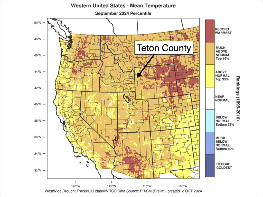
Temperatures were well above normal throughout the state of Wyoming in September and across most of the Western U.S.
The town of Jackson recorded 1.42 inches of rainfall in September, which is slightly below the September average of 1.65 inches. However, areas north of town in the valley received above-average rainfall, ranging from 2 to 3 inches.
All of Teton County’s precipitation in September fell before the 20th, with completely dry conditions from the 20th to the 30th.

Current Weather Pattern
October is starting out just the way September ended – warm, dry, and occasionally breezy. The weather is beautiful and comfortable, but unfortunately, wildfires continue to burn near Togwotee Pass with smoke filtering into the Jackson Hole Valley at times.
There is also a fire burning in the Caribou Mountains west of Alpine that is sending a little bit of smoke into our area.
Smoke conditions vary day to day and hour to hour, but generally speaking, smoke is thickest from early/mid-morning through early afternoon before dispersing high into the atmosphere late in the day.
Cold/dense air in the morning hours causes the smoke plume from the fires to collapse and sink toward the lower elevations, spreading out into the valleys. The shorter days and cold mornings at this time of year mean it takes longer for the lower atmosphere to heat up sufficiently for the smoke to rise and disperse out of the valleys.
Disturbances passing north of our area on Wednesday and again on Friday/Saturday will keep gusty winds in our forecast for the next several days, but we will not see any meaningful moisture in this pattern. Fire danger will remain elevated due to the dry and breezy conditions.
High temperatures will range from the upper 60s to upper 70s over the next week, which is above normal for October. Average highs in early October are in the low to mid 60s.
High pressure will be the dominant pattern over the next week, and this will result in continued dry conditions with the storm track remaining well north of our area.

October Outlook
October is a month of transition as we shift from warmer weather to colder weather – sometimes very quickly.
The average high temperature in Jackson in September is 73ºF and the average high in October is 56ºF, which is the biggest change in average high temperatures from one month to the next for the entire year.
Days continue to get shorter at this time of year, and freezing overnight temperatures are routine.
Despite the colder change, conditions vary widely at this time of year and it’s not uncommon to have long stretches of mild and dry weather with highs in the 60s and 70s, especially early in the month.
At the same time, cold snaps are also possible at this time of year and the town of Jackson and valley areas below 6,500 feet usually see their first snowfall of the season in October.
The town of Jackson averages 1.82 inches of precipitation in October (rain and melted snow), and 3.3 inches of snow. Across the higher terrain, snow becomes more common in October, especially later in the month, with an average of 31 inches of snowfall at the Rendezvous Bowl Plot at 9,580 feet.
For October 2024, confidence is high that conditions will be warmer and drier than normal with high pressure expected to dominate the weather pattern through at least the first half of the month. Get out and enjoy the dry trails while you can, but also be wary of wildfire smoke and continued high fire danger.
There are no indications yet of when colder and wetter conditions may arrive, and when snow could begin to set in across the higher elevations. But climatologically speaking, the odds of colder temperatures and snow will increase later in the month.
Alan Smith, Meteorologist


