
JACKSON, Wyo. – An unseasonably cold pattern with abundant late-season snow has persisted through the first week of March in Western Wyoming. This pattern will come to an abrupt end late this week as an atmospheric river containing subtropical moisture arrives, resulting in warmer temperatures and snow changing to rain in the valley on Friday.
An unseasonably cold start to March with abundant snowfall
Despite what the calendar says, the first week of March has felt more like early January in Jackson Hole – much to the delight of skiers enjoying late-season powder conditions, and much to the chagrin of those dreaming of warm weather after a long, cold winter.
The long-term average high and low in Jackson during the month of March is 43.9ºF and 18.1ºF. So far in March 2023, we have not come close to hitting these averages. Through the first seven days of the month, high temperatures have ranged from 21ºF to 33ºF and low temperatures have ranged from -16ºF to 15ºF.
The snowy finish to February has continued into March as well. So far this month, snow totals have already ranged from 30-40 inches in the Tetons above 9,000 feet and the Town of Jackson has received 7.8 inches. Snow quality has also been dry and powdery thanks to the cold airmass in place.
Snowfall numbers have been very impressive this winter as most areas are already above-average for the season. Jackson Hole’s Rendezvous Bowl Plot is closing in on 500 inches and the Town of Jackson is closing in on 100 inches.

In the Town of Jackson, abundant snowfall and consistent below-average temperatures have resulted in an impressive snowpack. In fact, on March 5 the snow depth hit 30 inches in town for only the second time in the last 10 years. The only other time this happened in the last 10 years was in early March 2019.
Snowpack Update
Mountain snowpack is currently 107% of average across the Upper Snake River Basin. Within this basin, the snowpack is deepest relative to average in the Teton Range but is actually a little below average at Togwotee Pass and across the Gros Ventre Range.

Snowpack continues to run above average for most major river basins across Wyoming.

Atmospheric river on track to bring warmer temperatures and low elevation rain on Friday
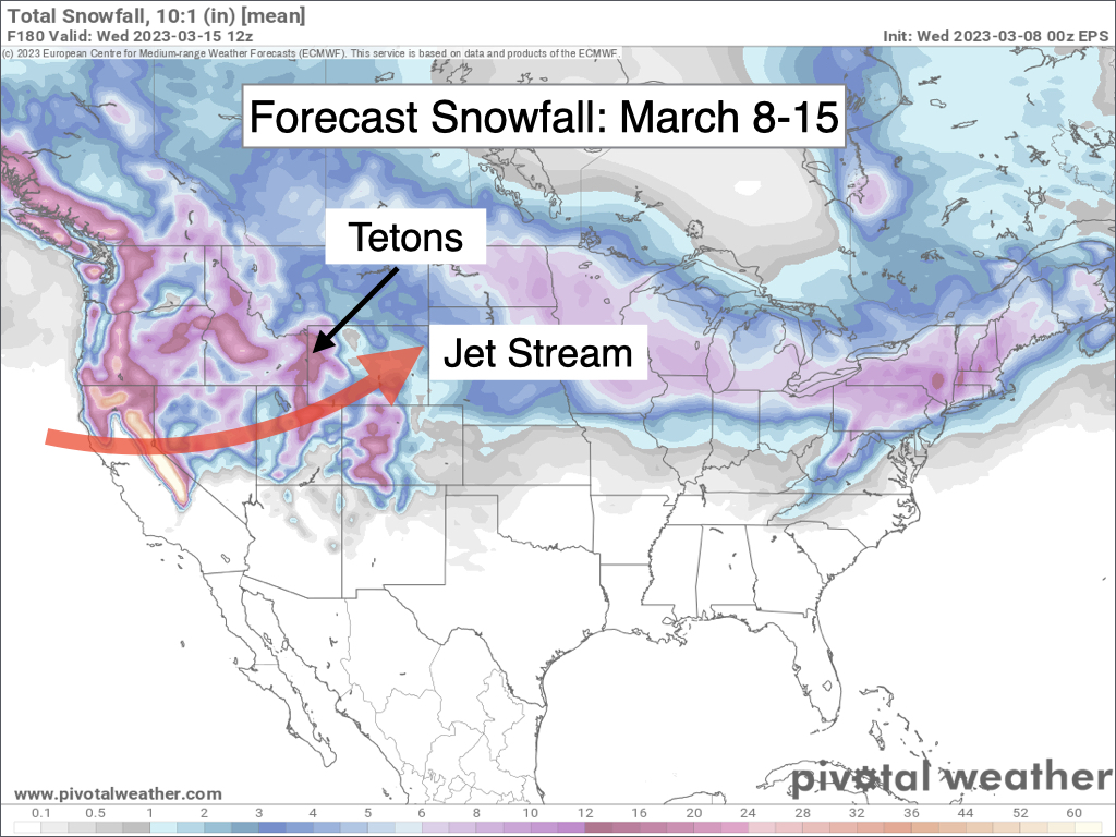
A powerful jet stream will transport a plume of rich subtropical moisture into California late this week, and strong southwest winds will drive this moisture plume into Western Wyoming, resulting in a significant change in the weather pattern compared to recent weeks.
This type of pattern is formally known as an atmospheric river, or more informally as a “Pineapple Express” due to moisture originating in the South Pacific near Hawaii.

Prior to Friday’s storm, we will see one last “cold” storm involving powder snow quality on Wednesday afternoon and evening. This will be a weaker storm with snow showers expected from Wednesday afternoon through Thursday morning. Snow totals will range from 2-5 inches in the Tetons and 1-2 inches in the valley.
We will see a break in the pattern on Thursday afternoon with temperatures remaining on the chilly side. Snow will then begin late Thursday night as the next storm arrives from the southwest.
Initially, snow will fall on the valley floor through Friday morning with accumulations of 1-4 inches. However, temperatures will steadily rise over the course of the day on Friday with a changeover to rain expected in the valley by Friday afternoon with rain continuing through Friday evening.
Snow levels are also going to peak as high as 7,000-7,500 feet on Friday afternoon and evening, which will result in the potential for wet avalanches across the lower elevations. Freezing levels could also peak at 8,000 feet or higher.
The warmer air will result in a transition to wet, high-density snow across the higher elevations of the Tetons above 8,000 feet. Total snowfall from Thursday night through Friday night will range from 5-10 inches above 8,000 feet.
Total liquid-equivalent precipitation will range from 1 to 1.5 inches in the Tetons and 0.5 to 0.75 inches in the Jackson Hole Valley.
Winds will also be very strong out of the southwest on Friday, especially during the late afternoon and evening. Peak gusts of 60-80 mph can be expected in exposed terrain above 9,000 feet, while the valley will see peak gusts of 30-40 mph.
A cold front will arrive late Friday night with snow levels falling to near the valley floor behind the front. However, moisture will be trailing the front with minimal snowfall expected behind the front at this time.
Travel conditions during this event will be most impactful in the valleys on Friday morning before the change-over to rain occurs, while Teton Pass will see poor conditions on both Friday morning and Friday evening with snowpacked and slushy roads along with strong winds and poor visibility expected.
After this storm, we will see a lull in the pattern from Saturday through Sunday with highs in the 30s in the valley. A weaker storm is then projected to arrive on Sunday night and Monday with light to moderate snow.
Another storm is possible on Tuesday (March 14) and early indications are hinting this one could involve warm air and valley rain as well. However, we are still close to a week away so the outlook could change.
Bottom line: Expect a transition from a winter snowpack to a spring snowpack across the lower elevations over the next week.
Here is a temperature outlook for the lower valley over the next 7 days:

Also, here is a 7-day snowfall projection from multiple simulations of the European Model, which indicates that snow will continue to fall frequently across the higher elevations:
Extended Outlook
From March 16-22, an active pattern will remain in place across the Western U.S. with frequent snow chances expected for the Tetons. Temperatures will generally be a little cooler than average but still warmer compared to recent weeks with a gradually receding snowpack in the valley.
Alan Smith, Meteorologist


