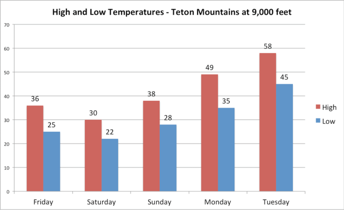
A cold and wet storm system will impact Jackson Hole over the next 36-48 hours. This storm has been tricky to nail down with regards to timing and details, so give yourself a wide margin for error if you have outdoor plans this weekend. Also, expect to see snow falling at times on Saturday. The heaviest precipitation will occur on Friday and Saturday with some light shower activity lingering into Sunday as well.
Friday:
Off-and-on rain showers will continue throughout the day on Friday, with the most widespread coverage expected in the afternoon and evening hours. The rain/snow line will range from 7,500-9,000 ft. on Friday afternoon before falling only gradually on Friday night.
Saturday:
A cold front will arrive around mid-morning Saturday, at which point snow levels will fall to 5,500-6,500 ft. As a result, it is likely we will see some snow showers in the town of Jackson though meaningful accumulations are not expected. Farther north in the GTNP valley, anywhere from a dusting to a few inches of snow will be possible, and the potential will be even higher in Yellowstone where up to several inches could fall.
We will continue to see a mix of rain and snow showers on Saturday in the Jackson Hole valley with highs only reaching the low 40s. Rain/snow shower activity will gradually become lighter and more isolated on Saturday night. Across the higher elevations of the Tetons, storm total snow amounts from Friday morning through Saturday night will range from 8-16 inches above 8,500 ft.
Sunday:
Unfortunately, the latest trends have slowed down this storm a bit, and as a result, Sunday is looking cooler and more unsettled than originally thought. Scattered light showers will remain possible through Sunday morning, with decreasing chances in the afternoon. Overall, it will be a drier day than Saturday but not exactly a warm and sunny day either.
Monday-Tuesday:
Conditions will finally dry out on Monday as high pressure builds over Wyoming with highs reaching the low 60s. Tuesday will see a more significant warm-up with highs near 70, but there will be a chance for an afternoon shower or thunderstorm.
Alan Smith, Meteorologist


