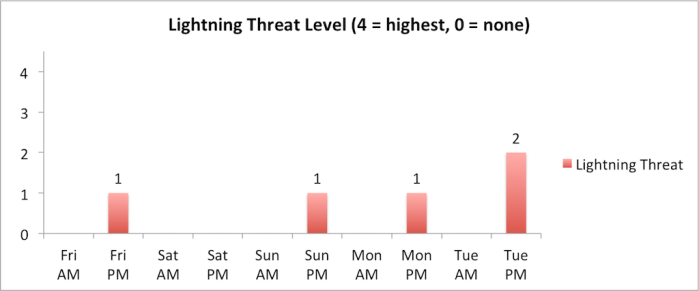
We’ll see one more cool and unsettled day on Friday before a significant warm-up occurs over the weekend. Showers early on Friday morning have largely tapered off for now and the threat for rain will be relatively low through about lunchtime. The next disturbance will arrive on Friday afternoon, leading to increasing rain showers chances through the afternoon and evening. A rumble of thunder also can’t be ruled out. Light winds on Friday morning will increase out of the west/southwest during the afternoon.
The rain/snow line on Friday afternoon/evening will range from 7,000-8,000 ft. with 1-3 inches of snow possible above 8,000 ft. Shower activity should come to an end across Teton County by midnight on Friday night.
High pressure will strengthen over Wyoming this weekend, leading to a big warm-up over the next few days. Mostly sunny skies and dry conditions can be expected on Saturday with highs getting into the low 60s after a chilly start to the morning.
On Sunday, temperatures will soar into the 70s in the valley as a strong southerly flow takes hold. This will also result in scattered high-level clouds as well as gusty winds throughout the day. There is also a minor chance that a thunderstorm could develop Sunday afternoon, so keep your eyes out for building clouds if you are out and about.
Similar conditions are expected on Monday with very warm temperatures, gusty winds from the south and a low chance for an afternoon thunderstorm. The warmth on Sunday and Monday will extend to the higher elevations as well, leading to an increase in snowmelt rates, runoff and likely some wet avalanche activity.
Shower and thunderstorm chances will increase on Tuesday afternoon ahead of an approaching low pressure system, which will also usher in cooler temperatures by the middle of next week.
Alan Smith, Meteorologist


